
Clyde is a city in Cloud County, Kansas, United States. As of the 2020 census, the population of the city was 694. It is located east of Concordia along state highway K-9.
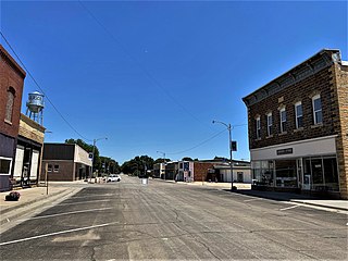
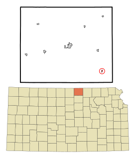
Glasco is a city in Cloud County, Kansas, United States. As of the 2020 census, the population of the city was 441.

Jamestown is a city in Cloud County, Kansas, United States. As of the 2020 census, the population of the city was 237.
Agenda is a city in Republic County, Kansas, United States. As of the 2020 census, the population of the city was 47.

Greenleaf is a city in Washington County, Kansas, United States. As of the 2020 census, the population of the city was 350.

Sabetha is a city in Brown and Nemaha counties in the U.S. state of Kansas. As of the 2020 census, the population of the city was 2,545.
Huscher is an unincorporated community in Cloud County, Kansas, United States.
Anness is an unincorporated community in Sedgwick County, Kansas, United States. It is located about 4.75 miles west of Viola, between W 111th St S and W 119th St S, and between S 327th St W and S 343rd St W.

Franklin is an unincorporated community in Crawford County, Kansas, United States. As of the 2020 census, the population of the community and nearby areas was 473. Franklin is located along U.S. Route 69, 1 mile (1.6 km) south of Arma, or 5.9 miles (9.5 km) north of Frontenac.
Elmont is an unincorporated community in northern Shawnee County, Kansas, United States.
White Rock is a ghost town in Republic County, Kansas, United States. It is located 6 miles north of Courtland.
Capioma is an unincorporated community in Capioma Township, Nemaha County, Kansas, United States.

Ashton is an unincorporated community in Walton Township, Sumner County, Kansas, United States. It is located about halfway between South Haven and Arkansas City at 1.75 miles north of the intersection of S Rock Rd and U.S. Route 166, which is 5.5 miles east of I-35, next to an abandoned railroad.
Bayneville is an unincorporated community in Ohio Township, Sedgwick County, Kansas, United States. It is located on S 87th W between W 71st S and W 79st S.
Berwick is an unincorporated community in Nemaha County, Kansas, United States.
Boyd is an unincorporated community in Eureka Township, Barton County, Kansas, United States.
Claudell is an unincorporated community in Valley Township, Smith County, Kansas, United States.
Darlow is an unincorporated community in Lincoln Township, Reno County, Kansas, United States. It is located several miles west of Yoder along Red Rock Road.
Macyville is a ghost town in Cloud County, Kansas, United States.
Ewell is a ghost town in Sumner County, Kansas, United States. It is located about 3.5 miles southwest of Conway Springs at 0.25 mile southeast of the intersection of N Bluff Rd and W 60th Ave N, next to an abandoned railroad.

