Solska Forest (Polish: Puszcza Solska) is a large forest complex in southern part of the Lublin Voivodeship, about 100km south of Lublin, Poland. It occupies an area north of the San and south of the Roztocze Upland. The forest is mostly made of coniferous trees[1], part of them having been artificially planted. Its total area is 1240km2, which makes it the second largest forest of Poland (the Lower Silesian Forest ranks first). Until the late Middle Ages, the Solska Forest was connected with another huge complex, the Sandomierz Forest, but deforestation separated these two complexes from each other.
Solska Forest is rich in landscape parks (such as the Puszcza Solska Landscape Park), nature reserves and peat bogs. Main rivers that cross the area are the Tanew, and the Łada and main cities are Biłgoraj, Tomaszów Lubelski and Józefow. The forest is crossed by several routes, including the main national road number 17, which goes from Warsaw, via Lublin, to Lviv. Also, a Zwierzyniec–Bełżec rail line goes through it.
The Lublin Voivodeship, also known as the Lublin Province, is a voivodeship (province) of Poland, located in southeastern part of the country. It was created on January 1, 1999, out of the former Lublin, Chełm, Zamość, Biała Podlaska and (partially) Tarnobrzeg and Siedlce Voivodeships, pursuant to Polish local government reforms adopted in 1998. The region is named after its largest city and regional capital, Lublin, and its territory is made of four historical lands: the western part of the voivodeship, with Lublin itself, belongs to Lesser Poland, the eastern part of Lublin Area belongs to Red Ruthenia, and the northeast belongs to Polesie and Podlasie. Lublin Voivodeship borders Subcarpathian Voivodeship to the south, Świętokrzyskie Voivodeship to the south-west, Masovian Voivodeship to the west and north, Podlaskie Voivodeship along a short boundary to the north, Belarus and Ukraine to the east. The region's population as of 2019 was 2,112,216. It covers an area of 25,155 square kilometres (9,712 sq mi).
Subcarpathian Voivodeship or Subcarpathia Province is a voivodeship, or province, in the southeastern corner of Poland. Its administrative capital and largest city is Rzeszów. Along with the Marshall, it is governed by the Subcarpathian Regional Assembly. Historically, most of the province's territory was part of the Kingdom of Galicia–Volhynia, the Kingdom of Galicia and Lodomeria and the Ruthenian Voivodeship. In the interwar period, it was part of the Lwów Voivodeship.
Biłgoraj(listen) is a town in south-eastern Poland with 25,838 inhabitants as of December 2021. Since 1999 it has been situated in Lublin Voivodeship; it was previously located in Zamość Voivodeship (1975–1998). It is located south of Lublin and it is also the capital of Biłgoraj County. Historically, the town belongs to Lesser Poland, and is located in southeastern corner of the province, near the border with another historic land, Red Ruthenia. Biłgoraj is surrounded by a forest, with three rivers flowing through it.
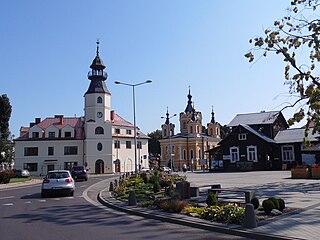
Tomaszów Lubelski is a town in south-eastern Poland with 19,365 inhabitants (2017). Situated in the Lublin Voivodeship, near Roztocze National Park, it is the capital of Tomaszów Lubelski County.
Wigry National Park is a national park in Podlaskie Voivodeship in north-eastern Poland. It covers parts of the Masurian Lake District and Augustów Primeval Forest. It is named after lake Wigry, the largest of the park's many lakes. It is also classed as a Ramsar wetland site, one of 13 such sites in Poland.
Roztocze National Park is a national park in Lublin Voivodeship of southeastern Poland. It protects the most valuable natural areas of the middle part of the Roztocze range. Its current size is 84.83 km2 (32.75 sq mi), of which forests occupy 81.02 km2, and strictly protected areas 8.06 km2. The park has its headquarters in Zwierzyniec.
Szczebrzeszyn Landscape Park is a protected area in Lublin Voivodeship in eastern Poland, created to protect the natural, cultural and historic values of the Roztocze region. Almost the whole area of the Park is situated in the eastern part of the Western Roztocze region, with the valley of the Gorajec river and sections of the valleys of the Wieprz and Por rivers within its territory.
Roztocze is a range of hills in east-central Poland and western Ukraine which rises from the Lublin Upland and extends southeastward through Solska Forest and across the border into Ukrainian Podolia. Low and rolling, the range is approximately 180 km long and 14 km wide. Its highest peak within Poland is Wielki Dział at 390 meters, while in Ukraine it is Vysokyi Zamok at 409 m. In Poland Roztocze lies in the Lublin and Podkarpackie voivodships, while the portion in Ukraine extends all the way to the outskirts of Lviv. In 2011 UNESCO established the Roztochya Biosphere Reserve. The Polish portion of the range makes up the Roztocze National Park.
Lublin Upland is a geographical region in southeastern Poland, located in Lublin Voivodeship, between the rivers Vistula and Bug, around the city of Lublin. Its area is about 7,200 km² and its highest elevation 314 m above sea level. It is located in Lublin Voivodeship. In its southern portion it becomes the Roztocze range, and in the north, it turns into Lublin Polesie. Biggest cities of the region are Lublin, Chełm, Zamość, Puławy, and Kraśnik. In some geography works, the term Lublin Upland (or is used to describe all Polish uplands located east of the Vistula river. In this case, Roztocze, with its highest point also makes part of Lublin Upland.
Gmina Aleksandrów is a rural gmina in Biłgoraj County, Lublin Voivodeship, in eastern Poland. Its seat is the village of Aleksandrów, which lies approximately 16 kilometres (10 mi) south-east of Biłgoraj and 91 km (57 mi) south of the regional capital Lublin.
Sopot is a small river in Poland. It originates near the Majdan Sopocki village and flows through Roztocze hills, passing through villages of Ciotusza Stara, Nowiny, Hamernia, and Osuchy. It is a tributary of Tanew.
Gmina Józefów is an urban-rural gmina in Biłgoraj County, Lublin Voivodeship, in eastern Poland. Its seat is the town of Józefów, which lies approximately 24 kilometres (15 mi) east of Biłgoraj and 92 km (57 mi) south of the regional capital Lublin.
Gmina Łukowa is a rural gmina in Biłgoraj County, Lublin Voivodeship, in eastern Poland. Its seat is the village of Łukowa, which lies approximately 23 kilometres (14 mi) south-east of Biłgoraj and 100 km (62 mi) south of the regional capital Lublin.
Gmina Obsza is a rural gmina in Biłgoraj County, Lublin Voivodeship, in eastern Poland. Its seat is the village of Obsza, which lies approximately 31 kilometres (19 mi) south-east of Biłgoraj and 108 km (67 mi) south of the regional capital Lublin.
Gmina Susiec is a rural gmina in Tomaszów Lubelski County, Lublin Voivodeship, in eastern Poland. Its seat is the village of Susiec, which lies approximately 18 kilometres (11 mi) west of Tomaszów Lubelski and 100 km (62 mi) south-east of the regional capital Lublin.
Gmina Narol is an urban-rural gmina in Lubaczów County, Subcarpathian Voivodeship, in south-eastern Poland. Its seat is the town of Narol, which lies approximately 26 kilometres (16 mi) north-east of Lubaczów and 101 km (63 mi) east of the regional capital Rzeszów.
Janów Forests Landscape Park,, is a Polish Landscape Park designated protected area in southeastern Poland.
South Roztocze Landscape Park is a protected area in eastern Poland, established in 1989.
Puszcza Solska Landscape Park, also known as Solska Forest Landscape Park, is a Polish Landscape Park protected area in southeastern Poland.
Szczecin Landscape Park "Beech Woods" is a protected area in north-western Poland, established in 1981 and covering an area of 91 square kilometres (35 sq mi). Its full name refers to the dense forest known as Puszcza Bukowa, which covers most of the area of the Park.
This page is based on this Wikipedia article Text is available under the CC BY-SA 4.0 license; additional terms may apply. Images, videos and audio are available under their respective licenses.