Wardha is a city and a municipal council in Wardha district in the Indian state of Maharashtra. The administrative headquarter of Wardha district is situated here. Wardha gets its name from the Wardha River which flows on the northern, western and southern boundaries of the district. Founded in 1866, the town is now an important centre for cotton trade. Wardha was an important part of the Gandhian era.

Osmanabad District, officially known as Dharashiv District, is an administrative district in the Marathwada region in the Indian state of Maharashtra. The district headquarter is located at Osmanabad. The District of Osmanabad derives its name from the last ruler of Hyderabad, the 7th Nizam, Mir Osman Ali Khan, of which the region was a part till 1947. This region was earlier part of The Hyderabad State until Independence.This primarily rural district occupies an area of 7,569 km2 (2,922 sq mi) of which 241.4 km2 (93.2 sq mi) is urban and has a population of 1,657,576 of which 16.96% were urban.
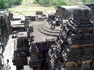
Aurangabad district, officially known as Chhatrapati Sambhaji Nagar district, is one of the 36 districts of the state of Maharashtra in western India. It borders the districts of Nashik to the west, Jalgaon to the north, Jalna to the east, and Ahmednagar to the south. The city of Aurangabad houses the district's administrative headquarters. The district has an area of 10,100 km2, of which 37.55% is urban and the rest is rural. Aurangabad District is a major tourism region in Marathwada, with attractions including the Ajanta Caves and Ellora Caves.
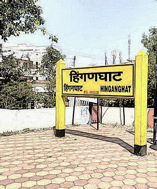
Hinganghat is a city in Wardha district of the Indian state of Maharashtra. The city is administered by a Municipal Council and is located about 35 km (22 mi) from Wardha and 72 km (45 mi) from Maharashtra's second capital Nagpur.
Nanded district is a district of Maharashtra state in central India. The city of Nanded is the district headquarters.
Tuljapur is a town with a municipal council in Dharashiv district in the Indian state of Maharashtra. It is the administrative seat of Tuljapur taluka.
Gadhinglaj ([ɡəɖᵊɦiŋɡləd͡z]) is a city in India in the Kolhapur district in the southwest corner of the state of Maharashtra, India. It is located on the banks of the river Hiranyakeshi. It is the Taluka (Tehsil) headquarters of Gadhinglaj Taluka and a subdivision headquarters of the Gadhinglaj Subdivision of the Kolhapur District. It is governed by a municipal council. The rapidly growing city is the third largest in the Kolhapur District, with population of more than 50,000. Places to visit like Samagad fort, temples and beautiful weather.
Jintur city and a municipal council in Parbhani district in the Indian state of Maharashtra.
Pachora is a town and a municipal council in Jalgaon district in the Indian state of Maharashtra. It sits on the banks of the Hivra River. It includes 25 wards with 25 members of Nagarpalika. Pachora has a large rural infrastructure with 95 gram panchayats which is the largest in any other tehsil place in Maharashtra. The Central Pachora is under Jalgaon Lok sabha Constituency.
Pathri is a town, near the city of Parbhani and a municipal council in Parbhani district in the Indian state of Maharashtra. It has been claimed that Pathri is the real birthplace of Sai Baba, which has been subject to controversy. Maharashtra CM had initially granted Rs 100-crore for development of birthplace facilities at Pathri, but later dropped all references to 'Janmsthan'. Pathri Premier League (PPL) is a popular annual cricket tournament organised in the city to boost local cricketing talent.
Selu also known as Sailu is a city and a municipal council in Parbhani district in the Indian state of Maharashtra.
Tasgaon is a city in Maharashtra and Taluka in Sangli district in the Indian state of Maharashtra. Tasgaon city is developing city in Maharashtra. Tasgaon was given as Jahagir to Parshuram Bhau Tasgaonkar by Narayanrao Ballal Peshwa in 1774. Tasgaon Sansthan was lapsed by British during ruling of Shrimant Ganpatrao Tasgaonkar.

Wani is a 3rd largest city in Yavatmal district in the Indian state of Maharashtra.

Aundha Naganath is a town in the Aundha Nagnath subdivision of Hingoli district. It lies in the Marathwada region of the Indian state of Maharashtra. The town is known for the Aundha Nagnath Temple, it is the 8th Jyotirling out of 12 which is dedicated to Shiva. The famous tourist spot along with the Temple includes the beautiful Garden and the Reserved Forest Region on the outskirts of the town.
Mantha is a town in Jalna district in the state of Maharashtra, India.
Palus is a city and municipal council in sangli district. Palus is developed city in Sangli district. City have best industrial zone, steel firms, foundries and Precision Machine shop.

Navipet is a Mandal in Nizamabad district in the state of Telangana in India Navipet is top mandal in Nizamabad district Which has good market value for crops and small revenue business. Navipet lies on Nizamabad Bhainsa main road. Navipet is famous for weekly goats market.
Palam is a town and headquarters of Palam taluka. It is located in Parbhani district in the Indian state of Maharashtra.

Durgi is a census village & Panchayat Headquarter of Bissam Cuttack Block in Rayagada district of Odisha, India. There are total 439 families residing in this village. The wards/ villages comes under Durgi Panchayat are:- Durgi, Bhaleri, Kundanpadar, Rengabai, Barangpadar, Thambalpadhu, Budhanagar, Kachapai, Kalipadar, Kurankul, Tentili Kalipadar, Mulipada, Dharamguda, Balipadar, Haduguda, Huruguda, Khariguda and IAY Colony.
The Hadgaon taluka or Hadgaon tehsil is a taluka in the Nanded district of the Indian state of Maharashtra. This tehsil includes one municipal council, Hadgaon, and 154 villages.

