Sotk

Last updated • 4 min readFrom Wikipedia, The Free Encyclopedia

40°12′11″N45°51′53″E / 40.20306°N 45.86472°E / 40.20306; 45.86472

Contents

Sotk
Սոթք
Tesaran Sot`k`i lerhnants`k`its` 02.jpg
Mountains around Sotk
Armenia adm location map.svg
Red pog.svg
Sotk
Gegharkunik Marz-01.svg
Red pog.svg
Sotk
Coordinates: 40°12′11″N45°51′53″E / 40.20306°N 45.86472°E / 40.20306; 45.86472
CountryArmenia
Province Gegharkunik
Municipality Vardenis
Founded15th century
Elevation
2,032 m (6,667 ft)
Population
 (2011) [1]
  Total
824
Time zone UTC+4 (AMT)
Sotk at GEOnet Names Server

Sotk (Armenian : Սոթք) is a village in the Vardenis Municipality of the Gegharkunik Province of Armenia, well known for its gold mines. [2]

Etymology

According to J. Markwart and N. Adonts, the name Sotk may be connected to the name of a tribe called Tsavde (atsvots) mentioned in ancient Armenian sources, [3] while others connect it with the toponym Suta (or Shuta) of the Hittite sources [3] (the presence of the Hittites was proposed in the vicinity of Lake Sevan in 2009). [4] According to the 13th century Armenian historian, Stepanos Orbelian, the town and its respective canton were named after the cold and stormy weather. [5]

History

7th century St. Astvatsatsin Church in Sotk -Sot`k`, Sowrb Astvatsatsin ekeghets`i.jpg
7th century St. Astvatsatsin Church in Sotk
Map of Syunik (pink) in the 9th century Arcax.jpg
Map of Syunik (pink) in the 9th century

Sotk has been well known for its mines throughout its history. The mines may have been exploited as early as the 2nd millennium BC, evidenced by the discovery of pits, funnels covered with grass, underground workings, wooden tools, stone mortars, washing pots, and more. The mines were used with interruptions until the 14th century AD, and later rediscovered in the 20th century.

Bronze Age

Materials, cemeteries, weapons, bones, and everyday life objects, belonging to the early Bronze Age, have been found in complexes of settlements around the Sotk mountain pass. [6] During this time, gold may have been acquired by alluvial way, while real mining may have begun in the later Bronze Age. [7]

On the southern slope of the mine, ruins of a large ancient settlement are visible, from where a grass-covered path led to the mine (in 1954, this path would be turned into a road for miners). The river valley is covered by artificial oval terraces which steep from the side towards the river flow. [8] West of Sotk, around the nearby town of modern Vardenis, are some cyclopean fortresses, with corresponding cemeteries from the 2nd and 1st millennium BC, among which is Tsovak, where there is a cuneiform inscription by Urartian king Sarduri II. To the north is a settlement of the Kura-Araxes culture. Many other such ruins can be found near Sotk such as in Chambarak, indicating the Lake Sevan basin was a significant region, controlled from centers like Ishtikuni (Lchashen) and confederations of chiefdoms, such as the Uduri-Etiuni and Uelikuni (both of which seem to have been Armenian etymologically) mentioned in Urartian sources. Elite tombs in Lchashen were rich with gold, which, according to metallurgical analyses, would have derived from Sotk. [9]

Antiquity to Middle Ages

At some point during the late Iron Age, the highlands known as "Urartu" became known as "Armenia" (see Urartu § Fall). As the first Armenian political entity expanded eastwards, the regions around Sotk were incorporated as core regions of ancient Armenia.

During Antiquity and the Middle Ages, Sotk was part of Syunik, one of the regions of the ancient and the medieval kingdoms of Armenia, where it served as the capital of the region of the same name. Its location on the mountain pass was at a strategic point on the medieval Dvin-Partav road, connecting the southern and eastern regions of the South Caucasus. [8]

The 7th century St. Astvatsatsin Church, an Armenian basilica church with 13th century khachkars in its walls is located in the village. [10] [11]

Late modern period

The modern village was only founded in 1829, [12] [ non-primary source needed ] and its official name was Zod (Armenian : Զոդ). [13] [ verification needed ] The village had an Azerbaijani-majority population before the exodus of Azerbaijanis from Armenia after the outbreak of the Nagorno-Karabakh conflict. From 1988 and onwards, Armenian refugees from Azerbaijan settled in the village. [12] [14]

In September 2022, Sotk as well as several other Armenian towns, including Vardenis (Gegharkunik Province), Goris (Syunik Province) and Jermuk (Vayots Dzor Province), came under attack by Azerbaijani Armed Forces. Many residential houses were damaged as a result of the shelling; people were displaced from their homes. [15] [16]

Gold mine

Sotk Gold Mine Sotk Gold Mine.jpg
Sotk Gold Mine

A gold mine near the village, called Sotk (Zod), is one of the largest gold deposits in the South Caucasus. [17] It is located on the border of Kalbajar District in Azerbaijan and Gegharkunik Province of Armenia. [18] Kalbajar District was administrated by the breakaway Republic of Artsakh from its control by Armenian forces in 1993 after the Battle of Kalbajar, near the end of the First Nagorno-Karabakh War, [19] until 2020, when the Armenian side handed it over to Azerbaijan according to the ceasefire agreement, ending the 2020 Nagorno-Karabakh war. [20]

Azerbaijani forces entered the district on 25 November, [21] and on 26 November, Armenian media reported that a group of 250 Azerbaijani soldiers had arrived at the gold mine, and demanded its handover, [22] establishing a military post at the mine. [23] The Armenian defense ministry refuted this account, [24] stating that Azerbaijani forces, having found an Armenian border checkpoint unacceptable, contacted the Armenian side via loudspeaker and negotiated with Russian peacekeepers over the issue. Armenian and Azerbaijani authorities started to demarcate the border on the same day. [25] Armenian military authorities then stated that half of the mine area had been passed to Azerbaijan. [26]

Demographics

Population

According to Statistical Committee of Armenia 2011 census, the villages' current population is 824.

See also

Related Research Articles

<span class="mw-page-title-main">Gegharkunik Province</span> Province of Armenia

Gegharkunik is a province (marz) of Armenia. Its capital and largest city is Gavar. Gegharkunik is inhabited by approximately 209,669 people and the majority are ethnic Armenians.

<span class="mw-page-title-main">Kalbajar District</span> District of Azerbaijan

Kalbajar District is one of the 66 districts of Azerbaijan. It is located in the west of the country and belongs to the East Zangezur Economic Region. The district borders the districts of Lachin, Khojaly, Agdam, Tartar, Goranboy, Goygol and Dashkasan districts of Azerbaijan, as well as the Gegharkunik and Vayots Dzor provinces of Armenia. Its capital and largest city is Kalbajar. As of 2020, the district had a nominal population of 94,100.

<span class="mw-page-title-main">Shahumyan Province</span> Province

Shahumyan Province was a province of the breakaway Republic of Artsakh, de jure part of the Republic of Azerbaijan. The capital of the province was Karvachar. Shahumyan Province had 17 communities of which one is considered urban and 16 are rural. Its bordered Martakert Province to the east, Kashatagh Province to the south, Gegharkunik and Vayots Dzor provinces of Armenia to the west and Dashkasan, Goygol and Goranboy districts of Azerbaijan to the north.

<span class="mw-page-title-main">Vardenis</span> Place in Gegharkunik, Armenia

Vardenis is a town in the Vardenis Municipality of the Gegharkunik Province of Armenia. It is located in the valley of the Masrik River, on the territory of the Masrik artesian basin at 2,006 metres above sea level, near the southeastern shores of Lake Sevan. It is 170 kilometres by road east of the capital Yerevan, and 75 kilometres southeast of the provincial centre Gavar. The administrative territory of Vardenis comprises 3,006 hectares, of which 736 hectares is occupied by the town itself. Vardenis obtained its status as an urban settlement in 1995. As of the 2011 census, the population of the town was 12,685. However, as per the 2016 official estimate, the population of Vardenis is 12,600.

<span class="mw-page-title-main">Mehmana</span> Place

Mehmana is a village located in the Kalbajar District of Azerbaijan, in the region of Nagorno-Karabakh. Until 2023 it was controlled by the breakaway Republic of Artsakh. The village had an ethnic Armenian-majority population until the exodus of the Armenian population of Nagorno-Karabakh following the 2023 Azerbaijani offensive in Nagorno-Karabakh.

Arpunk is a village in the Vardenis Municipality of the Gegharkunik Province of Armenia. Three kilometers southeast of the village is a 15th-century church. The village was populated by Azerbaijanis before the exodus of Azerbaijanis from Armenia after the outbreak of the Nagorno-Karabakh conflict. In 1988-1989 Armenian refugees from Azerbaijan settled in the village.

Avazan is a village in the Vardenis Municipality of the Gegharkunik Province of Armenia. The village was populated by Azerbaijanis before the exodus of Azerbaijanis from Armenia after the outbreak of the Nagorno-Karabakh conflict. In 1988-1989 Armenian refugees from Azerbaijan settled in the village.

Kutakan is a village in the Vardenis Municipality of the Gegharkunik Province of Armenia.

<span class="mw-page-title-main">Norabak</span> Place in Gegharkunik, Armenia

Norabak is a village in the Vardenis Municipality of the Gegharkunik Province of Armenia. The village was populated by Azerbaijanis before the exodus of Azerbaijanis from Armenia after the outbreak of the Nagorno-Karabakh conflict. In 1988-1989 Armenian refugees from Azerbaijan settled in the village.

<span class="mw-page-title-main">Pokr Masrik</span> Place in Gegharkunik, Armenia

Pokr Masrik is a village in the Vardenis Municipality of the Gegharkunik Province of Armenia. Azerbaijanis lived in the village prior to their exodus from Armenia after the outbreak of the Nagorno-Karabakh conflict. From 1988 and onward, Armenian refugees from Azerbaijan settled in the village. The village is located close to Mets Masrik.

Shatjrek is a village in the Vardenis Municipality of the Gegharkunik Province of Armenia. The village was populated by Azerbaijanis before the exodus of Azerbaijanis from Armenia after the outbreak of the Nagorno-Karabakh conflict. In 1988-1989 Armenian refugees from Azerbaijan settled in the village.

<span class="mw-page-title-main">Kalbajar</span> Place in Azerbaijan

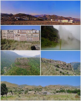
Kalbajar is a city and the capital of the Kalbajar District of Azerbaijan. Located on the Tartar river valley, it is 458 kilometres (285 mi) away from the capital Baku.

Arajadzor or Dovshanly is a village located in the Kalbajar District of Azerbaijan, in the region of Nagorno-Karabakh. Until 2023 it was controlled by the breakaway Republic of Artsakh. The village had an ethnic Armenian-majority population until the exodus of the Armenian population of Nagorno-Karabakh following the 2023 Azerbaijani offensive in Nagorno-Karabakh.

<span class="mw-page-title-main">Dashalty</span> Place in Shusha, Azerbaijan

Dashalty or Karin Tak is a village in the Shusha District of Azerbaijan, in the region of Nagorno-Karabakh. Until 2020, the village was controlled by the Republic of Artsakh. The village had an ethnic Armenian-majority population prior to the 2020 Nagorno-Karabakh war, and also had an Armenian majority in 1989.

<span class="mw-page-title-main">Zar, Azerbaijan</span> Place in Kalbajar, Azerbaijan

Zar is a village in the Kalbajar District of Azerbaijan.

<span class="mw-page-title-main">Armenian-occupied territories surrounding Nagorno-Karabakh</span> Formerly occupied territories of Azerbaijan

The Armenian-occupied territories surrounding Nagorno-Karabakh were areas of Azerbaijan, situated around the former Nagorno-Karabakh Autonomous Oblast (NKAO), which were occupied by the ethnic Armenian military forces of the breakaway Republic of Artsakh with military support from Armenia, from the end of the First Nagorno-Karabakh War (1988–1994) to 2020, when the territories were returned to Azerbaijani control by military force or handed over in accordance to the 2020 Nagorno-Karabakh ceasefire agreement. The surrounding regions were seized by Armenians under the justification of a "security belt" which was to be traded for recognition of autonomous status from Azerbaijan.

<span class="mw-page-title-main">Shosh, Nagorno-Karabakh</span> Place in Khojaly, Azerbaijan

Shosh or Shushikend is a village in the Khojaly District of Azerbaijan, in the region of Nagorno-Karabakh. Until 2023 it was controlled by the breakaway Republic of Artsakh. The village had an ethnic Armenian-majority population until the exodus of the Armenian population of Nagorno-Karabakh following the 2023 Azerbaijani offensive in Nagorno-Karabakh.

<span class="mw-page-title-main">Sotk gold mine</span> Mine in Armenia, Azerbaijan

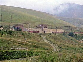
The Sotk gold mine, known in Azerbaijan as the Zod gold mine, is the largest mine in Armenia and Azerbaijan in terms of pure gold reserves. It is located in the vicinity of the Sotk village in the Vardenis region of Armenia's Gegharkunik Province, and the adjacent part of the Kalbajar District of Azerbaijan. According to Armenian officials, the gold mine is split roughly in half between the two countries, while according to Azerbaijani officials, 74 percent of the mine lies on Azerbaijani territory.

<span class="mw-page-title-main">Operation Kalbajar</span> Military engagement in the First Nagorno-Karabakh War

Operation Kalbajar was a military offensive launched by the Azerbaijani Armed Forces in late 1993 against the forces of the Armenian Army and the self-proclaimed Nagorno-Karabakh Republic to recapture the district of Kalbajar in the final stage of the First Nagorno-Karabakh War.

<span class="mw-page-title-main">Kusanats Anapat</span>

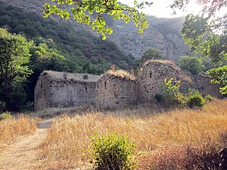
Kusanats Anapat, or Surb Astvatsatsin is an Armenian monastery in the Kalbajar District in Azerbaijan, about 3 km northwest of Dadivank Monastery.

References

  1. Statistical Committee of Armenia. "The results of the 2011 Population Census of Armenia" (PDF).
  2. Kiesling, Brady; Kojian, Raffi (2005). Rediscovering Armenia: Guide (2nd ed.). Yerevan: Matit Graphic Design Studio. p. 82. ISBN   99941-0-121-8.
  3. 1 2 Hakobyan T.Ch., Melik-Bakhshyan S.T., Barseghyan H.Ch., Hayastani ev harakits shrjanneri teghanunneri bararan (Toponymical Dictionary of Armenia and Surrounding Regions), v. 2, 313, Yerevan, 1988–2001.
  4. Petrosyan A., The ‘Eastern Hittites’ in the South and East of the Armenian Highland? Armenian Journal of Near Eastern Studies IV/1 (2009), pp. 63–72
  5. Աբրահամյան, Ա․ Ա․ (1986). ՍՏԵՓԱՆՈՍ ՕՐԲԵԼՅԱՆ ՍՅՈՒՆԻՔԻ ՊԱՏՄՈՒԹՅՈՒՆ (in Armenian). Երևան: Սովետական գրող. p. 70.
  6. Xnkikyan O.S. (1977). Arhestnery bronzedaryan Hayastanum (Crafts in Bronze Age Armenia). Yerevan. p. 14.{{cite book}}: CS1 maint: location missing publisher (link)
  7. Gevorgyan A., Zalibekyan М. (2007). Kalantaryan. p. 30.
  8. 1 2 Aram Gevorgyan, Arsen Bobokhyan "METALLURGY OF ANCIENT ARMENIA IN CULTURAL AND HISTORICAL CONTEXT" Archived 1 May 2018 at the Wayback Machine , Armenian National Academy of Sciences . Retrieved on 1 May 2018.
  9. Xnkikyan O.S. (1977). Arhestnery bronzedaryan Hayastanum (Crafts in Bronze Age Armenia). Yerevan. p. 18.{{cite book}}: CS1 maint: location missing publisher (link)
  10. "Armenia: Gegharkunik Province Guidebook by Svetlana Dingarac – Issuu". 25 November 2015.
  11. "Archived copy". Archived from the original on 24 October 2021. Retrieved 9 December 2020.{{cite web}}: CS1 maint: archived copy as title (link)
  12. 1 2 "ՍՈԹՔ". gegharkunik.am. Archived from the original on 22 July 2022. Retrieved 17 February 2021.
  13. Ադամյան, Ն., ed. Հայկական ՍՍՌ վարչա-տերիտորիալ բաժանումը: Առ 1-ը մարտի 1964 թ. Երևան : Հայաստան , 1964; p. 34, 79
  14. "Waiting to go home: The plight of Nagorno-Karabakh's refugees". reliefweb.int. ReliefWeb. 3 June 2003. Archived from the original on 15 July 2006.
  15. "PanARMENIAN.Net – Mobile". panarmenian.net.
  16. "Ադրբեջանական հարձակման հետևանքով առնվազն 2570 անձ տեղահանվել է. ՄԻՊ". www.1lurer.am. 14 September 2022.
  17. "Kelbajar gold deposits to remain on territory of Azerbaijan". Vestnik Kavkaza. 27 November 2020. Retrieved 27 November 2020.
  18. "Azərbaycan MN Zod mədəni ilə bağlı yayılan xəbərlərə şərh verməyib". BBC Azerbaijani Service (in Azerbaijani). 27 November 2020. Retrieved 27 November 2020.
  19. Year: 1993), UN Security Council (48th (12 November 1993). "Resolution 884 (1993) /: adopted by the Security Council at its 3313th meeting, on 12 November 1993" via digitallibrary.un.org.{{cite web}}: CS1 maint: numeric names: authors list (link)
  20. "Azerbaijani army enters Kalbajar, region returned by Armenia". Al Jazeera . 25 November 2020. Retrieved 27 November 2020.
  21. "Azerbaijani leader vows to revive region ceded by Armenia". Associated Press . 25 November 2020. Retrieved 27 November 2020.
  22. "Глава общины Гегамасар: "Азербайджанские ВС отошли назад в районе Сотка в Армении"". ArmenianReport. 27 November 2020. Retrieved 27 November 2020.
  23. "В Генштабе ВС Армении не видят поводов для волнения из-за появления азербайджанских солдат в Сотке". ArmenianReport. 27 November 2020. Retrieved 27 November 2020.
  24. Ghazanchyan, Siranush (26 November 2020). "Azerbaijani troops have not entered the area of Sotk gold mine – Defense Ministry". Public Radio of Armenia . Retrieved 27 November 2020.
  25. Aghalaryan, Kristine (26 November 2020). "Azerbaijani troops have not entered the area of Sotk gold mine – Defense Ministry". Hetq.am. Retrieved 27 November 2020.
  26. Ghukasyan, Seda (27 November 2020). "Half of Sotk Gold Mine Now in Azerbaijan, Says Armenian Military Official". Hetq.am. Retrieved 27 November 2020.