
The Fryingpan River is a tributary of the Roaring Fork River, approximately 42 miles (68 km) long, in west central Colorado in the United States.

The Blue River is a tributary of the Colorado River, approximately 65 miles (105 km) long, in the U.S. state of Colorado.

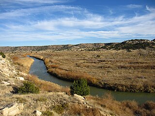
White River is a river, approximately 195 miles (314 km) long, in the U.S. states of Colorado and Utah and is a tributary of the Green River.

The Little Arkansas River is a river in the central Great Plains of North America. A tributary of the Arkansas River, its entire 123-mile (198 km) length lies within the American state of Kansas.

The Collegiate Peaks Wilderness is a 168,000-acre (680 km2) area located in central Colorado between Leadville and Buena Vista to the east and Aspen to the west and Crested Butte to the southwest. Most of the area is in the San Isabel and Gunnison National Forests, with a smaller area in the White River National Forest southeast of Aspen. Most of the area is in northwest Chaffee County with smaller portions in Gunnison, Pitkin, and Lake counties.

The Verdigris River is a tributary of the Arkansas River in southeastern Kansas and northeastern Oklahoma in the United States. It is about 310 miles (500 km) long. Via the Arkansas, it is part of the Mississippi River watershed.

Mount Shavano is a high mountain summit in the southern Sawatch Range of the Rocky Mountains of North America. The 14,231-foot (4,338 m) fourteener is located in San Isabel National Forest, 6.5 miles (10.5 km) north by west of the community of Maysville in Chaffee County, Colorado, United States. The mountain was named in honor of Ute Chief Shavano.

The U.S State of Colorado includes the headwaters of several important rivers. The state is divided into two major hydrographic regions by the Continental Divide of the Americas. East of the Continental Divide, surface waters flow via the South Platte River, the North Platte River, the Republican River, the Arkansas River, the Cimarron River, the Canadian River, or the Rio Grande to the Gulf of Mexico. West of the Continental Divide, surface waters flow via the Green River, the upper Colorado River, or the San Juan River into the Colorado River and on to the Gulf of California. Colorado also has three significant endorheic basins: the San Luis Closed Basin in the San Luis Valley, and the Bear Creek Basin and the White Woman Basin spanning the Colorado-Kansas border north and south of the Arkansas River.
The Purgatoire River is a river in southeastern Colorado, United States. The river is also known locally as the Purgatory River or the Picketwire River. Purgatoire means Purgatory in French. French trappers named the river to commemorate Spanish explorers killed in a Native American attack.

The Indian Pass Wilderness is 32,418-acre (13,119 ha) wilderness area under the administered by the Bureau of Land Management. The reserve is located in the very southeastern part of the Chocolate Mountains, in the southeastern part of California, just to the west of the Colorado River in the Lower Colorado River Valley. It adjoins the Picacho Peak Wilderness to the south, and the Imperial National Wildlife Refuge to the east.
Big Piney Creek is a river located in Ozark National Forest in the state of Arkansas. It is a tributary of the Arkansas River and therefore part of the Mississippi River watershed. Managed by the United States Forest Service, it flows for 70.8 miles (113.9 km) through Pope, Johnson and Newton counties. The headwaters of the creek are in a rugged, remote area just east of Arkansas Route 21 south of the community of Fallsville and the mouth of the creek empties into Lake Dardanelle on the Arkansas River.

Big Sandy Creek is a 211-mile-long (340 km) tributary of the Arkansas River noted for being the location of the Sand Creek Massacre in Kiowa County. Long stretches are dry most of the time on the surface, although water still flows underground. Big Sandy Creek starts near Peyton in El Paso County, Colorado and flows through Elbert, Lincoln, Cheyenne and Kiowa counties before it joins with the Arkansas River in Prowers county east of Lamar.

Huerfano River is a 113-mile-long (182 km) tributary of the Arkansas River that flows from a source on Blanca Peak in the Sangre de Cristo Mountains of Colorado. It joins the Arkansas in Pueblo County just south of the town of Boone. One major tributary is the Cucharas River.
Two Butte Creek is a 152-mile-long (245 km) tributary of the Arkansas River that flows from a source near Kim, Colorado. It joins the Arkansas just south of the town of Holly.

Apishapa River is a 139-mile-long (224 km) tributary of the Arkansas River that flows from a source near West Spanish Peak in southern Colorado. It joins the Arkansas east of Fowler, Colorado. A U.S. Geological Survey (USGS) station, #07119500, located along this river near Fowler measures the river's discharge.

Saint Charles River is a 64.6-mile-long (104.0 km) tributary of the Arkansas River that flows from a source near Saint Charles Peak in the Wet Mountains of southern Colorado. It joins the Arkansas east of Pueblo, Colorado.

East Fork Arkansas River is a 20.6-mile-long (33.2 km) tributary of the Arkansas River that flows from a source in the Mosquito Range of central Colorado. It joins with Tennessee Creek to form the Arkansas River west of Leadville, Colorado.
Horse Creek is a 129-mile-long (208 km) tributary of the Arkansas River that flows from a source south of Calhan in the Holcolm Hills of El Paso County, Colorado. It flows east and south to a confluence with the Arkansas in Otero County west of Las Animas
Chico Creek is a 53.9-mile-long (86.7 km) tributary of the Arkansas River that flows from a source in El Paso County, Colorado. It joins the Arkansas in Pueblo County just west of the town of Avondale.


