South Henderson, North Carolina

Last updated

South Henderson, North Carolina
CDP
NCMap-doton-SouthHenderson.PNG
Location of South Henderson, North Carolina
Coordinates: 36°18′12″N78°24′21″W / 36.30333°N 78.40583°W / 36.30333; -78.40583
Country United States
State North Carolina
County Vance
Area
[1]
  Total1.80 sq mi (4.67 km2)
  Land1.80 sq mi (4.67 km2)
  Water0.00 sq mi (0.00 km2)
Elevation
[2]
512 ft (156 m)
Population
 (2020)
  Total988
  Density548.28/sq mi (211.69/km2)
Time zone UTC-5 (Eastern (EST))
  Summer (DST) UTC-4 (EDT)
FIPS code 37-63240 [3]
GNIS feature ID2402872 [2]

South Henderson is a census-designated place (CDP) in Vance County, North Carolina, United States. The population was 1,213 at the 2010 census.

Contents

Geography

According to the United States Census Bureau, the CDP has a total area of 1.9 square miles (5.0 km2), all land.

Demographics

Historical population
CensusPop.Note
2020 988
U.S. Decennial Census [4]

As of the census [3] of 2000, there were 1,220 people, 452 households, and 321 families residing in the CDP. The population density was 629.8 inhabitants per square mile (243.2/km2). There were 505 housing units at an average density of 260.7 per square mile (100.7/km2). The racial makeup of the CDP was 46.89% White, 49.02% African American, 0.08% Native American, 0.49% Asian, 0.41% Pacific Islander, 2.70% from other races, and 0.41% from two or more races. Hispanic or Latino of any race were 8.52% of the population.

There were 452 households, out of which 31.0% had children under the age of 18 living with them, 40.3% were married couples living together, 24.1% had a female householder with no husband present, and 28.8% were non-families. 24.1% of all households were made up of individuals, and 9.1% had someone living alone who was 65 years of age or older. The average household size was 2.70 and the average family size was 3.18.

In the CDP, the population was spread out, with 26.7% under the age of 18, 10.8% from 18 to 24, 27.1% from 25 to 44, 22.5% from 45 to 64, and 12.9% who were 65 years of age or older. The median age was 34 years. For every 100 females, there were 85.1 males. For every 100 females age 18 and over, there were 83.2 males.

The median income for a household in the CDP was $26,008, and the median income for a family was $36,389. Males had a median income of $26,563 versus $20,395 for females. The per capita income for the CDP was $15,221. About 6.3% of families and 8.2% of the population were below the poverty line, including 5.1% of those under age 18 and 4.4% of those age 65 or over.

Related Research Articles

<span class="mw-page-title-main">North Auburn, California</span> Census-designated place in California, United States

North Auburn is a census-designated place (CDP) in Placer County, California, United States. It is part of the Sacramento–Arden-Arcade–Roseville Metropolitan Statistical Area. The population was 13,452 at the 2020 census.

<span class="mw-page-title-main">Temelec, California</span> Census-designated place in California, United States

Temelec is a census-designated place (CDP) in Sonoma County, California, United States. The population was 1,441 at the 2010 census.

<span class="mw-page-title-main">Poplar-Cotton Center, California</span> Census-designated place in California, United States

Poplar-Cotton Center is a census-designated place (CDP) in Tulare County, California, United States. The population was 2,470 at the 2010 census, up from 1,496 at the 2000 census.

<span class="mw-page-title-main">June Park, Florida</span> Census-designated place in Florida

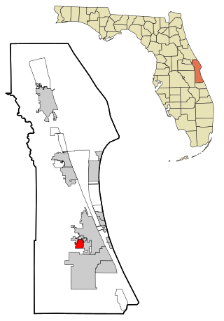
June Park is a census-designated place (CDP) in Brevard County, Florida. The population was 4,094 at the 2010 United States Census. It is part of the Palm Bay–Melbourne–Titusville Metropolitan Statistical Area.

<span class="mw-page-title-main">Honomu, Hawaii</span> Census-designated place in Hawaii, U.S.

Honomū is a census-designated place (CDP) in Hawaiʻi County, Hawaii, United States. The population was 509 at the 2010 census, down from 541 at the 2000 census.

<span class="mw-page-title-main">Henderson, Illinois</span> Village in Illinois, United States

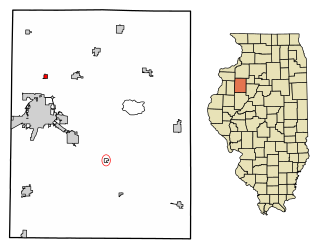
Henderson is a village in Knox County, Illinois, United States. The population was 255 at the 2010 census, down from 319 at the 2000 census. It is part of the Galesburg Micropolitan Statistical Area.

Goodings Grove was a census-designated place in northern Will County, Illinois, United States. The population was 17,084 at the 2000 census. It is now a neighborhood of the village of Homer Glen, Illinois, which was incorporated in 2001.

<span class="mw-page-title-main">Placitas, Sandoval County, New Mexico</span> CDP in New Mexico, United States

Placitas is a census-designated place (CDP) in Sandoval County, New Mexico, United States. As of the 2010 census, its population was 4,977. It is part of the Albuquerque Metropolitan Statistical Area.

<span class="mw-page-title-main">Cuartelez, New Mexico</span> Census-designated place in New Mexico, United States

Cuartelez is a census-designated place (CDP) in Santa Fe County, New Mexico, United States. It is part of the Santa Fe, New Mexico Metropolitan Statistical Area. The population was 469 at the 2010 census.

<span class="mw-page-title-main">Laurel, New York</span> Hamlet and census-designated place in New York, United States

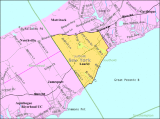
Laurel is a census-designated place (CDP) roughly corresponding to the hamlet of Laurel in Suffolk County, New York, United States. It is located mostly within the Town of Southold, with a small portion in the Town of Riverhead. The population was 1,394 at the 2010 census.

<span class="mw-page-title-main">Tillson, New York</span> CDP in New York, United States

Tillson is a hamlet in Ulster County, New York, United States. The population was 1,516 at the 2020 census.

<span class="mw-page-title-main">St. Stephens, North Carolina</span> Census-designated place in North Carolina, United States

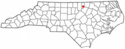
St. Stephens is a census-designated place (CDP) in Catawba County, North Carolina, United States. The population was 8,759 at the 2010 census, down from 9,439 in 2000. It is part of the Hickory–Lenoir–Morganton Metropolitan Statistical Area.

<span class="mw-page-title-main">East Flat Rock, North Carolina</span> Census-designated place in North Carolina, United States

East Flat Rock is an unincorporated area and census-designated place (CDP) in Henderson County, North Carolina, United States. The population was 4,995 at the 2010 census, up from 4,151 at the 2000 census. It is part of the Asheville Metropolitan Statistical Area.

<span class="mw-page-title-main">Valley Hill, North Carolina</span> Census-designated place in North Carolina, United States

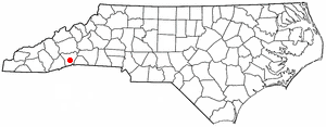
Valley Hill is an unincorporated community and census-designated place (CDP) in Henderson County, North Carolina, United States. The population was 2,070 at the 2010 census. It is part of the Asheville Metropolitan Statistical Area.

<span class="mw-page-title-main">Fruit Hill, Ohio</span> Census-designated place in Ohio, United States

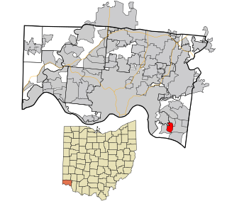
Fruit Hill is a census-designated place (CDP) in Hamilton County, Ohio, United States. The population was 3,748 at the 2020 census. Fruit Hill is located at 39°4′15″N84°21′53″W. According to the United States Census Bureau, the CDP has a total area of 1.3 square miles (3.3 km2), all land.

<span class="mw-page-title-main">Maple Ridge, Ohio</span> Census-designated place in Ohio, United States

Maple Ridge is a census-designated place in southwestern Mahoning County, Ohio, United States, located between Alliance and Sebring. The population was 667 at the 2020 census. It is part of the Youngstown–Warren metropolitan area.

<span class="mw-page-title-main">Village Green-Green Ridge, Pennsylvania</span> Census-designated place in Pennsylvania, United States

Village Green-Green Ridge is a census-designated place (CDP) in Delaware County, Pennsylvania, United States. The population was 7,822 at the 2010 census, down from 8,279 at the 2000 census.

Cane Savannah is a census-designated place (CDP) in Sumter County, South Carolina, United States. The population was 1,452 at the 2000 census. It is included in the Sumter, South Carolina Metropolitan Statistical Area.

<span class="mw-page-title-main">Weallup Lake, Washington</span> Former CDP in Washington, United States

Weallup Lake is a former census-designated place (CDP) in Snohomish County, Washington, United States. The population was 882 at the 2000 census. The CDP was discontinued at the 2010 census.

<span class="mw-page-title-main">Pleasant Valley (CDP), New York</span> Census-designated place in New York, United States

Pleasant Valley is a census-designated place (CDP) in the southwestern part of the town of Pleasant Valley in Dutchess County, New York, United States. The population was 1,145 at the 2010 census. It is part of the Poughkeepsie–Newburgh–Middletown, NY Metropolitan Statistical Area as well as the larger New York–Newark–Bridgeport, NY-NJ-CT-PA Combined Statistical Area.

References

  1. "ArcGIS REST Services Directory". United States Census Bureau. Retrieved September 20, 2022.
  2. 1 2 U.S. Geological Survey Geographic Names Information System: South Henderson, North Carolina
  3. 1 2 "U.S. Census website". United States Census Bureau . Retrieved January 31, 2008.
  4. "Census of Population and Housing". Census.gov. Retrieved June 4, 2016.