Southern California is a geographic and cultural region that generally comprises the southern portion of the U.S. state of California. It includes the Los Angeles metropolitan area, the second most populous urban agglomeration in the United States. The region generally contains ten of California's 58 counties: Imperial, Kern, Los Angeles, Orange, Riverside, San Bernardino, San Diego, Santa Barbara, San Luis Obispo and Ventura counties. The Colorado Desert and the Colorado River are located on southern California's eastern border with Arizona, and San Bernardino County shares a border with Nevada to the northeast. Southern California's southern border with Baja California is part of the Mexico–United States border.

Charter Oak is a census-designated place (CDP) in Los Angeles County, California, approximately 26 miles (42 km) east of downtown Los Angeles. The population was 9,310 at the 2010 census, up from 9,027 at the 2000 census.

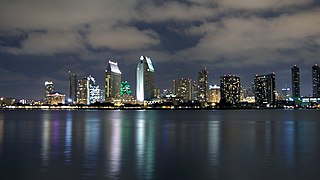
Glendora is a city in the San Gabriel Valley in Los Angeles County, California, 26 miles (42 km) east of Los Angeles. As of the 2010 census, the population of Glendora was 50,073.

The Santa Monica Mountains is a coastal mountain range in Southern California, next to the Pacific Ocean. It is part of the Transverse Ranges. Because of its proximity to densely populated regions, it is one of the most visited natural areas in California. Santa Monica Mountains National Recreation Area is located in this mountain range.

The San Gabriel Mountains are a mountain range located in northern Los Angeles County and western San Bernardino County, California, United States. The mountain range is part of the Transverse Ranges and lies between the Los Angeles Basin and the Mojave Desert, with Interstate 5 to the west and Interstate 15 to the east. The range lies in, and is surrounded by, the Angeles and San Bernardino National Forests, with the San Andreas Fault as its northern border.
The San Gabriel Valley is one of the principal valleys of Southern California, lying generally to the east of the city of Los Angeles. Surrounding features include:

The Santa Susana Mountains are a transverse range of mountains in Southern California, north of the city of Los Angeles, in the United States. The range runs east-west, separating the San Fernando Valley and Simi Valley on its south from the Santa Clara River Valley to the north and the Santa Clarita Valley to the northeast. The Oxnard Plain is to the west of the Santa Susana Mountains.

The Pomona Valley is located in the Greater Los Angeles Area between the San Gabriel Valley and San Bernardino Valley in Southern California. The valley is approximately 30 miles east of downtown Los Angeles, which can often be seen from nearby foothills. It ranges from the city of San Dimas from the far west to Rancho Cucamonga to the far east portion of the valley. The alluvial valley is formed by the Santa Ana River and its tributaries.
The Foothill Freeway is a freeway in the Los Angeles metropolitan area of the U.S. state of California, running from the Sylmar district of Los Angeles east to Redlands. The western segment is signed as Interstate 210 (I-210) from its western end at Interstate 5 (I-5) to State Route 57 (SR 57) in Glendora, while the eastern segment is signed as State Route 210 (SR 210) to its eastern terminus at Interstate 10 (I-10). Under the California Streets and Highways Code, the entire Foothill Freeway is legally referred to as Route 210.

Area code 626 is a California telephone area code that was split from area code 818 on June 14, 1997. It covers most of the San Gabriel Valley and nearby areas in the northeastern portion of Los Angeles County, California, U.S., including Arcadia, Monrovia, El Monte, most of Pasadena and West Covina.

The Berkeley Hills are a range of the Pacific Coast Ranges that overlook the northeast side of the valley that encompasses San Francisco Bay. They were previously called the "Contra Costa Range/Hills", but with the establishment of Berkeley and the University of California, the current usage was applied by geographers and gazetteers.

George Dexter Whitcomb an American manufacturer and founder of the town of Glendora, California.
Law enforcement in Los Angeles County is conducted by a variety of law enforcement agencies.
The Southern California Association of Governments (SCAG) is the Metropolitan Planning Organization (MPO) of six of the ten counties in Southern California, serving Imperial County, Los Angeles County, Orange County, Riverside County, San Bernardino County, and Ventura County. San Diego County's MPO is the San Diego Association of Governments, which is an unrelated agency.

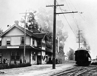
The Monrovia–Glendora Line was a route on the Pacific Electric Railway serving the San Gabriel Valley. It ran from 1902 to 1951, supporting nearby real estate development.
The Upland–San Bernardino Line was an interurban line operated by the Pacific Electric Railway between Downtown Los Angeles and San Bernardino, California. This line also had shorter service that terminated before the end of the line at Baldwin Park, Covina, and San Dimas. Though service along this line in its entirety was discontinued in November 1941, it stands as the fourth-longest rapid transit line in American history, after the Sacramento Northern Chico and Colusa services, and the Pacific Electric's own Riverside–Rialto Line.
The Glendora Historical Society is a privately funded nonprofit organization based in Glendora, California. The Society produces original exhibitions; maintains a collection of historical documents, photographs, and other research materials; and hosts educational events.
