South Mills, North Carolina

Last updated

South Mills, North Carolina
South Mills NC bridge 2020a.jpg
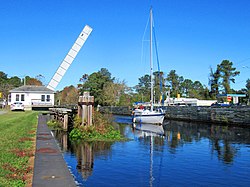
Highway bridge open for passage of sailboat at South Mills on the Intracoastal Waterway (Dismal Swamp Canal)
Camden County North Carolina incorporated and unincorporated areas South Mills highlighted.svg
Location in Camden County and the state of North Carolina.
Coordinates: 36°26′16″N76°19′51″W / 36.43778°N 76.33083°W / 36.43778; -76.33083
Country United States
State North Carolina
County Camden
Area
[1]
  Total1.79 sq mi (4.64 km2)
  Land1.79 sq mi (4.64 km2)
  Water0.00 sq mi (0.00 km2)
Elevation
[2]
3 ft (0.9 m)
Population
 (2020)
  Total362
  Density202.12/sq mi (78.05/km2)
Time zone UTC-5 (Eastern (EST))
  Summer (DST) UTC-4 (EDT)
ZIP code
27976
Area code 252
GNIS feature ID2628656 [2]
FIPS code37-63340

South Mills is an unincorporated community and census-designated place (CDP) in Camden County, North Carolina, United States. [2] Its population was 454 as of the 2010 census. [3] South Mills has a post office with ZIP code 27976, which opened on March 2, 1840. [4] [5] The community is located near U.S. Route 17, and U.S. Route 17 Business and North Carolina Highway 343, and future Interstate 87 (North Carolina) pass through the community.

Contents

The community derived its name from a watermill which operated near the original town site. [6]

The William Riley Abbott House, Dismal Swamp Canal, and Morgan House are listed on the National Register of Historic Places. [7]

Demographics

Historical population
CensusPop.Note
2020 362
U.S. Decennial Census [8]

2020 census

South Mills racial composition [9]
RaceNumberPercentage
White (non-Hispanic)28177.62%
Black or African American (non-Hispanic)5013.81%
Asian 20.55%
Other/Mixed 256.91%
Hispanic or Latino 41.1%

As of the 2020 United States census, there were 362 people, 181 households, and 139 families residing in the CDP.

Related Research Articles

Iron Station is an unincorporated community and census-designated place (CDP) in Lincoln County, North Carolina, United States. A primarily industrial town, Iron Station's population was 755 as of the 2010 census. It also serves as a bedroom community for the larger cities of Charlotte, Hickory, and Lincolnton.

<span class="mw-page-title-main">Coinjock, North Carolina</span> Census-designated place in North Carolina, United States

Coinjock is an unincorporated community and census-designated place (CDP) in Currituck County, North Carolina, United States. As of the 2010 census it had a population of 335. It is located on U.S. Route 158 between Barco and Grandy, about 20 miles (32 km) south of the Virginia state line, and is at mile marker 50 on the southern portion of the Albemarle and Chesapeake Canal, on the Intracoastal Waterway. Church's Island to the east of Coinjock in the Currituck Sound has a village called Waterlily, which uses the postal address of Coinjock as well. The island's name is due to a decayed church that was once a landmark of the tiny community. Coinjock is bordered by Currituck Sound to the east; the North River lies to the west. Its ZIP Code is 27923.

Advance is an unincorporated community and census-designated place (CDP) in Davie County, North Carolina, United States. It is seventy-five miles northeast of Charlotte. As of the 2010 census it had a population of 1,138. It is located along North Carolina Highway 801 just south of Bermuda Run. Advance is part of the Piedmont Triad region of North Carolina.

<span class="mw-page-title-main">Ledgewood, New Jersey</span> Populated place in Morris County, New Jersey, US

Ledgewood is an unincorporated community and census-designated place (CDP) located within Roxbury Township in Morris County, in the U.S. state of New Jersey. It was historically known as Drakesville after Abraham Drake, originally from Piscataway, New Jersey, who operated a mill and tavern here in the mid 1700s. The community was located on the Morris Canal.

Fairfield is a census-designated place (CDP) and unincorporated community in Hyde County, North Carolina, United States. As of the 2010 census it had a population of 258. The Fairfield Historic District was listed on the National Register of Historic Places in 1985.

<span class="mw-page-title-main">Moncure, North Carolina</span> Census-designated place in North Carolina, United States

Moncure, founded in 1881, is a small rural unincorporated community in southeastern Chatham County, North Carolina, United States. Moncure and the neighboring community of Haywood form the Moncure census-designated place (CDP), which had a population of 711 at the 2010 census. The community is located near the confluence of the Deep and Haw rivers, which form the Cape Fear River. Moncure once served as the westernmost inland port in the state, linked to the Atlantic Ocean by steamships.

<span class="mw-page-title-main">Asbury, New Jersey</span> Populated place in Warren County, New Jersey, US

Asbury is an unincorporated community and census-designated place (CDP) located within Franklin Township in Warren County, in the U.S. state of New Jersey, that was created as part of the 2010 United States Census. As of the 2010 Census, the CDP's population was 273.

<span class="mw-page-title-main">Stewartsville, New Jersey</span> Populated place in Warren County, New Jersey, US

Stewartsville is an unincorporated community and census-designated place (CDP) located within Greenwich Township in Warren County, in the U.S. state of New Jersey, that was created as part of the 2010 United States Census. As of the 2010 Census, the CDP's population was 349.

<span class="mw-page-title-main">Chestertown, New York</span> Hamlet & CDP in New York, United States

Chestertown is a hamlet of the Town of Chester, in Warren County, New York, United States. It is located by the junction of Route 8 and U.S. Route 9, in the Adirondack Mountains. The population was 677 at the 2010 census, which lists the community as a census-designated place.

Hollister is a census-designated place and unincorporated community in Halifax County in northeastern North Carolina, United States. As of the 2010 census it had a population of 674. Hollister's ZIP code is 27844.

Sunbury is a census-designated place (CDP) and unincorporated community in Gates County, North Carolina, United States. As of the 2010 census, it had a population of 289.

Piffard is a census-designated place (CDP) and hamlet in the town of York, Livingston County, New York, United States. As of the 2010 census, its population was 220. The ZIP Code is 14533.

Horse Shoe is an unincorporated community and census-designated place (CDP) in Henderson County, North Carolina, United States. Its ZIP code is 28742. As of the 2010 census, its population was 2,351.

<span class="mw-page-title-main">Adams Run, South Carolina</span> Census-designated place in South Carolina, United States

Adams Run is an unincorporated community and census-designated place (CDP) in Charleston County, South Carolina, United States. It was first listed as a CDP in the 2020 census with a population of 421.

La France is an unincorporated community and census-designated place (CDP) in Anderson County, South Carolina. It was first listed as a CDP in the 2020 census with a population of 476.

Maury is an unincorporated community and census-designated place (CDP) in Greene County, North Carolina, United States. Its population was 1,685 as of the 2010 census. Maury has a post office with ZIP code 28554. North Carolina Highway 123 and North Carolina Highway 903 intersect in the community.

Cliffside is an unincorporated community and census-designated place (CDP) in southeastern Rutherford County, North Carolina, United States. Its population was 611 as of the 2010 census. Cliffside has a post office with ZIP code 28024. U.S. Route 221 Alternate and North Carolina Highway 120 pass through the community.

<span class="mw-page-title-main">Elliott, South Carolina</span> Census-designated place in South Carolina, United States

Elliott is an unincorporated community and census-designated place (CDP) in Lee County, South Carolina, United States. It was first listed as a CDP in the 2020 census with a population of 370.

Gillisonville is an unincorporated community and census-designated place (CDP) in Jasper County, in the U.S. state of South Carolina. It was first listed as a CDP in the 2020 census with a population of 183.

Hunt is a hamlet and census-designated place (CDP) in Livingston County, New York, United States. Its population was 78 as of the 2010 census. Hunt has a post office with ZIP code 14846.

References

  1. "ArcGIS REST Services Directory". United States Census Bureau. Retrieved September 20, 2022.
  2. 1 2 3 U.S. Geological Survey Geographic Names Information System: South Mills, North Carolina
  3. "Geographic Identifiers: 2010 Demographic Profile Data (G001): South Mills CDP, North Carolina". U.S. Census Bureau, American Factfinder. Archived from the original on February 12, 2020. Retrieved December 22, 2014.
  4. United States Postal Service (2012). "USPS - Look Up a ZIP Code" . Retrieved February 15, 2012.
  5. "Postmaster Finder - Post Offices by ZIP Code". United States Postal Service . Retrieved March 6, 2014.
  6. Federal Writers' Project (1938). The Ocean Highway: New Brunswick, New Jersey to Jacksonville, Florida. Works Progress Administration. p. 92.
  7. "National Register Information System". National Register of Historic Places . National Park Service. July 9, 2010.
  8. "Census of Population and Housing". Census.gov. Retrieved June 4, 2016.
  9. "Explore Census Data". data.census.gov. Retrieved December 22, 2021.