
The Boston Mountains is a Level III ecoregion designated by the Environmental Protection Agency (EPA) in the U.S. states of Arkansas and Oklahoma. Part of the Ozark Mountains, the Boston Mountains are a deeply dissected plateau. The ecoregion is steeper than the adjacent Springfield Plateau to the north, and bordered on the south by the Arkansas Valley. The Oklahoma portion of the range is locally referred to as the Cookson Hills.

The Swannanoa River flows through the Swannanoa Valley of the region of Western North Carolina, and is a major tributary to the French Broad River. Its headwaters arise in Black Mountain, NC; however, it also has a major tributary near its headwaters: Flat Creek, which begins on the slopes of Mount Mitchell. The Swannanoa River ends at its confluence with the French Broad, now within the grounds of the 8,000-acre Biltmore Estate in Asheville.
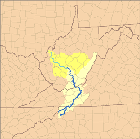
The South Fork New River is a river in the U.S. state of North Carolina.

The Mitchell River is a tributary of the Yadkin River in northwestern North Carolina in the United States. Via the Yadkin it is part of the watershed of the Pee Dee River, which flows to the Atlantic Ocean. According to the Geographic Names Information System, it has also been known historically as "Mitchells River," "Mitchels River," and "Mountain Creek."
The Roaring River is a tributary of the Yadkin River in northwestern North Carolina in the United States. Via the Yadkin it is part of the watershed of the Pee Dee River, which flows to the Atlantic Ocean. According to the Geographic Names Information System, it has also been known historically as "Roaring Creek." The river's name comes from its headwaters in the Blue Ridge Mountains, where it flows through a series of small waterfalls.

The Rio Chama, a major tributary river of the Rio Grande, is located in the U.S. states of Colorado and New Mexico. The river is about 130 miles (210 km) long altogether. From its source to El Vado Dam its length is about 50 miles (80 km), from El Vado Dam to Abiquiu Dam is about 51 miles (82 km), and from Abiquiu Dam to its confluence with the Rio Grande is about 34 miles (55 km).
The North Fork River or the North Fork of White River is a 109-mile-long (175 km) tributary of the White River, into which it flows near Norfork, Arkansas.

The Sugarland Mountain Trail is an American hiking trail, in the Great Smoky Mountains National Park of Sevier County, Tennessee. The trail traverses Sugarland Mountain, a massive ridge running perpendicular to the main crest of the Smokies and effectively dividing the park's north-central section from its northwestern section. Sugarland Mountain is flanked by the deep upper valleys of two of the park's major watersheds— the West Fork of the Little Pigeon River and Little River. The trail passes through several forest types, including deciduous forest at lower elevations, heaths ("hells") along the mountain's backbone formations, and a stand of Southern Appalachian spruce-fir forest in the upper elevations. Occasional breaks in the foliage allow for views of Mount Le Conte and Sevier County to the east and Blanket Mountain and the ridges above Elkmont to the west.

The Valley River is a tributary of the Hiwassee River. It arises as a pair of springs in the Snowbird Mountains of Cherokee County, North Carolina and descends 2,960 feet (900 m) in elevation in approximately forty miles (64 km) to enter the Hiwassee embayment at present-day Murphy, North Carolina.
Lehigh Mountain is a mountain in Lehigh County, Pennsylvania. The main peak rises to 843 feet (257 m), and is located in Salisbury Township. Lehigh Mountain is located on the right bank of the Lehigh River, and is separated from South Mountain by the headwaters of Trout Creek. It is part of the Reading Prong of the Appalachian Mountains.
Winsel Creek is a stream in Crawford and Franklin Counties in the U.S. state of Missouri. It is a tributary of Spring Creek in Franklin County.
Smith Branch is a stream in Montgomery County in the U.S. state of Missouri. It is a tributary of Clear Fork of the Loutre River.

Cove Mountain is a wildland in the George Washington and Jefferson National Forests of western Virginia that has been recognized by the Wilderness Society as a special place worthy of protection from logging and road construction.
Beaverdam Creek , a wildland in the George Washington and Jefferson National Forests of western Virginia and the Cherokee National Forest of eastern Tennessee, has been recognized by the Wilderness Society as a special place worthy of protection from logging and road construction. The Wilderness Society has designated the area as a "Mountain Treasure".
Busick is a populated place in Yancey County, North Carolina, United States.
Little Walker Mountain, a wildland in the George Washington and Jefferson National Forests of western Virginia, has been recognized by the Wilderness Society as a special place worthy of protection from logging and road construction. The Wilderness Society has designated the area as a "Mountain Treasure".

The Oconaluftee River drains the south-central Oconaluftee valley of the Great Smoky Mountains in Western North Carolina before emptying into the Tuckasegee River. The river flows through the Qualla Boundary, a federal land trust that serves as a reservation for the Eastern Band of the Cherokee (EBCI), the only federally recognized tribe in the state of North Carolina. They bought the land back from the federal government in the 1870s, after having been pushed off and forced to cede it earlier in the nineteenth century. Numerous historic Cherokee towns are known to have been located along this river.
Candy Creek is a 3.10 mi (4.99 km) long 1st order tributary to the Haw River, in Rockingham County, North Carolina.
Horsepen Creek is a 8.87 mi (14.27 km) long 3rd order tributary to Reedy Fork in Guilford County, North Carolina.

