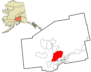
The Fairbanks North Star Borough is a borough located in the U.S. state of Alaska. As of the 2020 census, the population was 95,665, down from 97,581 in 2010. The borough seat is Fairbanks. The borough's land area is slightly smaller than that of the state of New Jersey.

Ferry is a census-designated place (CDP) in Denali Borough, Alaska, United States. The population was 17 at the 2020 census, down from 33 in 2010.

Healy is a census-designated place (CDP) and the borough seat of Denali Borough in the U.S. state of Alaska. The population was 966 at the time of the 2020 census, down from 1,021 in 2010.

College is a census-designated place (CDP) in Fairbanks North Star Borough, Alaska, United States. It is part of the Fairbanks, Alaska Metropolitan Statistical Area. As of the 2020 census, the population was 11,332, down from 12,964 in 2010. College is the third-most populated CDP in Alaska.

Fox is a census-designated place (CDP) in Fairbanks North Star Borough, Alaska, United States. It is part of the Fairbanks, Alaska Metropolitan Statistical Area. At the 2010 census the population was 417, up from 300 in 2000.

Harding-Birch Lakes is a census-designated place (CDP) in Fairbanks North Star Borough, Alaska, United States. It is part of the Fairbanks, Alaska Metropolitan Statistical Area. At the 2010 census the population was 299, up from 216 in 2000.

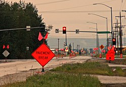
Moose Creek is a census-designated place (CDP) in Fairbanks North Star Borough in the U.S. state of Alaska. As of the 2010 census, the population of the CDP was 747, up from 542 in 2000. It is part of the Fairbanks, Alaska Metropolitan Statistical Area. Moose Creek is located south of Fairbanks, Alaska along the Richardson Highway. Moose Creek is bordered by Eielson Air Force Base to the south, the Tanana River to the west, and the Chena River Flood Control Project to the north.

Salcha is a census-designated place (CDP) in Fairbanks North Star Borough in the U.S. state of Alaska. It is part of the Fairbanks, Alaska Metropolitan Statistical Area. The population was 1,095 at the 2010 census, up from 854 in 2000.

Two Rivers is a census-designated place (CDP) in Fairbanks North Star Borough, Alaska, United States. It lies between mile 13 and mile 25 on the Chena Hot Springs Road, northeast of Fairbanks. As of the 2010 United States Census, the CDP had a population of 719, up from 482 in 2000.

Lutak is a census-designated place (CDP) in Haines Borough, Alaska, United States. The population was 49 at the 2010 census, up from 39 in 2000.

Kalifornsky is a census-designated place (CDP) in Kenai Peninsula Borough, Alaska, United States. The population was 8,487 at the 2020 census, up from 7,850 in 2010. It is the most populated locality in the borough.
Kodiak Station is a census-designated place (CDP) in Kodiak Island Borough, Alaska, United States. At the 2020 census the population was 1,673, up from 1,301 in 2010.

Petersville is a census-designated place (CDP) in Matanuska-Susitna Borough, Alaska, United States. It is part of the Anchorage Metropolitan Area. The population was 27 at the 2020 census.
Willow is a census-designated place (CDP) in the Matanuska-Susitna Borough in the U.S. state of Alaska. Located 26 miles northwest from Wasilla along the George Parks Highway, it is part of the Anchorage, Alaska Metropolitan Statistical Area. At the 2020 census the population was 2,196, up from 2,102 in 2010.
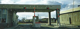
Alcan Border, also known as Port Alcan, is a census-designated place in the Southeast Fairbanks Census Area in the U.S. state of Alaska. Part of the Unorganized Borough, Alcan Border is the site of the Alcan - Beaver Creek Border Crossing, the main U.S. port of entry for persons arriving in Alaska by road. The population was 33 at the 2010 census, up from 21 in 2000.

Big Delta is a census-designated place (CDP) in Southeast Fairbanks Census Area, Alaska, United States. The population was 591 at the 2010 census, down from 749 in 2000. Big Delta is at the confluence of the Delta River and the Tanana River and gets its name from the huge river delta formed by the confluence.
Healy Lake is a census-designated place (CDP) in Southeast Fairbanks Census Area, Alaska, United States. The population was 13 at the 2010 census, down from 37 in 2000.
Tanacross is a census-designated place (CDP) in Southeast Fairbanks Census Area, Alaska, United States. At the 2010 census the population was 136, down from 140 in 2000. It hosts an air tanker base.
Circle is a census-designated place (CDP) in Yukon-Koyukuk Census Area, Alaska, United States. At the 2020 census the population was 91, down from 104 in 2010.

Badger is a census-designated place (CDP) in the Fairbanks North Star Borough of Alaska. It was one of the CDPs created in 2010 out of small suburbs and outskirts of Fairbanks. It has an area of 66.71 sq. mi, 65.63 of land and 1.08 of water.