
Otsego County is a county in the U.S. state of New York. As of the 2020 census, the population was 58,524. The county seat is Cooperstown. The county's population center is Oneonta. The name Otsego is from a Mohawk or Oneida word meaning "place of the rock."
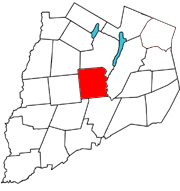
Hartwick is a town located in Otsego County, New York, United States. As of the 2010 census, the town had a population of 2,110. The Town of Hartwick is located in the middle of the county, southwest of the Village of Cooperstown.

Richfield Springs is a village located in the Town of Richfield, on the north-central border of Otsego County, New York, United States. The population was 1,264 at the 2010 census. The name is derived from local sulfur springs.

The New York Central Railroad was a railroad primarily operating in the Great Lakes and Mid-Atlantic regions of the United States. The railroad primarily connected greater New York and Boston in the east with Chicago and St. Louis in the Midwest, along with the intermediate cities of Albany, Buffalo, Cleveland, Cincinnati, Detroit, Rochester and Syracuse. New York Central was headquartered in New York City's New York Central Building, adjacent to its largest station, Grand Central Terminal.

Oneonta is a city in southern Otsego County, New York, United States. It is one of the northernmost cities of the Appalachian Region. Oneonta is home to the State University of New York at Oneonta and Hartwick College. SUNY Oneonta began as a normal school and a teacher's college in 1889, and Hartwick College moved into the city in 1928. The approximately 5,800 students from SUNY Oneonta and the approximately 1,500 students at Hartwick make up a significant percentage of the population of Oneonta. According to the 2020 U.S. Census, Oneonta had a population of 13,079. Its nickname is "City of the Hills." While the word "oneonta" is of undetermined origin, it is popularly believed to mean "place of open rocks" in the Mohawk language. This refers to a prominent geological formation known as "Table Rock" at the western end of the city.

New York State Route 28 (NY 28) is a state highway extending for 281.69 miles (453.34 km) in the shape of a "C" between the Hudson Valley city of Kingston and southern Warren County in the U.S. state of New York. Along the way, it intersects several major routes, including Interstate 88 (I-88), U.S. Route 20 (US 20), and the New York State Thruway twice. The southern terminus of NY 28 is at NY 32 in Kingston and the northern terminus is at US 9 in Warrensburg. In Kingston, NY 28 is co-designated as Interstate 587 from its southern terminus at NY 32 to the roundabout linking it to the Thruway (I-87).

Otsego Lake is a 4,046-acre (16.37 km2) lake located in Otsego County in the U.S. state of New York. It is the source of the Susquehanna River and largest lake in Otsego County. The Village of Cooperstown is located at the lake's southern end. Glimmerglass State Park is located on the lake's northeastern shore, and includes Hyde Hall, a large mansion constructed in 1817, that overlooks the lake. The Glimmerglass Opera, opened in June 1987, is located on the western shore.

The Delaware, Lackawanna and Western Railroad was a U.S. Class 1 railroad that connected Buffalo, New York, and Hoboken, New Jersey, a distance of 395 miles (636 km). Incorporated in Pennsylvania in 1853 primarily for the purpose of providing a connection between the anthracite coal fields of Pennsylvania's Coal Region and the large markets for coal in New York City. The railroad gradually expanded both East and West, eventually linking Buffalo with New York City.

The New York, Susquehanna and Western Railway is a Class II American freight railway operating over 400 miles (645 km) of track in the northeastern U.S. states of New York, Pennsylvania, and New Jersey.
Schuyler Lake is the name of a small hamlet in the town of Exeter in Otsego County, New York, United States. It lies at the south end of Canadarago Lake and south of Richfield Springs. It is also known as Kaniatarake, which is a Mohawk name that translates to "on the lake".

Canadarago Lake is a 1,917-acre (7.76 km2) lake located in Otsego County, New York and is the source of Oaks Creek. The Village of Richfield Springs is located at the lake's northern end. It is the second largest lake in Otsego County, lying to the west of and parallel to the larger Otsego Lake. The lake's name is also spelled "Candajarago Lake" or "Caniadaraga Lake".
The Ulster and Delaware Railroad (U&D) was a railroad located in the state of New York. It was often advertised as "The Only All-Rail Route to the Catskill Mountains." At its greatest extent, the U&D extended 107 miles (172 km) from Kingston Point on the Hudson River through the Catskill Mountains to its western terminus at Oneonta, passing through the counties of Ulster, Delaware, Schoharie and Otsego.

The Cooperstown and Charlotte Valley Railroad Company is a heritage railroad in New York, operated by the Leatherstocking Chapter of the National Railway Historical Society (NRHS) since 1996.
The Delaware Otsego Corporation (DO) is an American railway holding company which owns the New York, Susquehanna and Western Railway and the Central New York Railroad. It is headquartered in Cooperstown, New York in Otsego County.

New York State Route 167 (NY 167) is a north–south state highway in the Mohawk Valley region of New York in the United States. It extends for 26.17 miles (42.12 km) from an intersection with U.S. Route 20 (US 20) in the Otsego County village of Richfield Springs to a junction with NY 29 in the Herkimer County village of Dolgeville. Midway between the two endpoints, NY 167 passes through the city of Little Falls, where it meets NY 5 and indirectly connects to the New York State Thruway by way of NY 169. Most of NY 167 is a two-lane rural highway; however, in Little Falls, NY 167 ranges in width from two to four lanes as it serves commercial and industrial sections of the city.

New York State Route 205 (NY 205) is a 23.24-mile-long (37.40 km) north–south state highway in central Otsego County, New York, in the United States. It extends from Interstate 88 (I-88) at exit 13 near the city of Oneonta to a junction with NY 28 and NY 80 in the town of Otsego. The latter junction also marks the east end of a 2.1-mile (3.4 km) overlap between NY 205 and NY 80, from where NY 80 heads southeast to follow NY 28 to Cooperstown. NY 205 is a two-lane highway for its entire length and passes through the towns of Oneonta, Laurens and Hartwick.

The Central New York Railroad is a shortline railroad operating local freight service along ex-Southern Tier Line trackage in the U.S. states of New York and Pennsylvania. The line begins at Port Jervis, following the Delaware River to Deposit and the Susquehanna River from Lanesboro, where it passes over the Starrucca Viaduct, to Binghamton. It is a subsidiary of the Delaware Otsego Corporation, which also owns the New York, Susquehanna and Western Railway, operator of through trains over the line.

The Fonda, Johnstown and Gloversville Railroad (FJ&G) was formerly a 132-mile steam engine and electric interurban railroad that connected its namesake towns in east central New York State to Schenectady, New York. It had a successful and profitable transportation business from 1870 until the 1980s carrying workers, salesmen, and executives of the very large number of glove manufacturing companies in the area to the New York Central (NYC) station at Schenectady. From here they could catch trains south to New York City (NYC) or west to Chicago. It also handled freight and had freight interchange with both the New York Central and the Delaware and Hudson railroads. Passenger business declined starting before the Great Depression and particularly during it. Following a determined and expensive effort to recapture passenger business by acquiring five ultra modern high-speed Brill Bullet interurban cars in 1932, the FJ&G abandoned passenger service in 1938. Freight business continued on for a few more decades, was later taken over by the Delaware and Otsego Railroad management and then eventually abandoned.
South Hartwick is a hamlet in Otsego County, New York, United States. The community is located along Otsego County Route 11 which runs parallel with NY 205, 13 miles (21 km) north of Oneonta. South Hartwick is served by ZIP code 13348.


