Southwold is a seaside town and civil parish on the English North Sea coast in the East Suffolk district of Suffolk. It lies at the mouth of the River Blyth within the Suffolk Coast and Heaths Area of Outstanding Natural Beauty. The town is about 11 miles (18 km) south of Lowestoft, 29 miles (47 km) north-east of Ipswich and 97 miles (156 km) north-east of London, within the parliamentary constituency of Suffolk Coastal. The "All Usual Residents" 2011 Census figure gives a total of 1,098 persons for the town. The 2012 Housing Report by the Southwold and Reydon Society concluded that 49 per cent of the dwellings are used as second homes or let to holiday-makers.
Beccles is a market town and civil parish in the English county of Suffolk. The town is shown on the milestone as 109 miles (175 km) from London via the A145 and A12 roads, 98 miles (158 km) north-east of London as the crow flies, 16 miles (26 km) south-east of Norwich and 33 miles (53 km) north-northeast of the county town of Ipswich. Nearby towns include Lowestoft to the east and Great Yarmouth to the north-east. The town lies on the River Waveney on the edge of The Broads National Park.

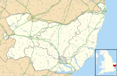
Lowestoft is a coastal town and civil parish in the East Suffolk district of Suffolk, England. As the most easterly UK settlement, it is 110 miles (177 km) north-east of London, 38 miles (61 km) north-east of Ipswich and 22 miles (35 km) south-east of Norwich, and the main town in its district. The estimated population in the built-up area exceeds 70,000. Its development grew with the fishing industry and as a seaside resort with wide sandy beaches. As fishing declined, oil and gas exploitation in the North Sea in the 1960s took over. While these too have declined, Lowestoft is becoming a regional centre of the renewable energy industry.
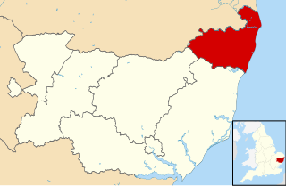
Waveney was a local government district in Suffolk, England, named after the River Waveney that formed its north-east border. The district council was based in Lowestoft, the major settlement in Waveney. The other towns in the district were Beccles, Bungay, Halesworth and Southwold.

Reydon is a village and civil parish, 1.0 mile (1.6 km) north-west of Southwold and 2.5 miles (4.0 km) south-east of Wangford, in the East Suffolk district and the ceremonial county of Suffolk, England. Its population of 2,567 in 2001 including Easton Bavents eased up to 2,582 at the 2011 Census, and was estimated at 2,772 in 2018. The name probably means Rye Hill, Rey meaning rye and -don being an old word for hill or rise). The village is close to the cliffs at Easton Bavents, a village now much eroded. Both were established before neighbouring Southwold. The parish church is St Margaret of Antioch. The parish of Easton Bavents was merged with Reydon in 1987, when part of Southwold was also transferred.
Halesworth is a market town, civil parish and electoral ward in north-eastern Suffolk, England. The population stood at 4,726 in the 2011 Census. It lies 15 miles (24 km) south-west of Lowestoft, on a tributary of the River Blyth, nine miles upstream from Southwold. The town is served by Halesworth railway station on the Ipswich–Lowestoft East Suffolk Line. It is twinned with Bouchain in France and Eitorf in Germany. Nearby villages include Cratfield, Wissett, Chediston, Walpole, Blyford, Linstead Parva, Wenhaston, Thorington, Spexhall, Bramfield, Huntingfield, Cookley and Holton.

Sotterley, originally Southern-lea from its situation south of the river, is a village and civil parish in the East Suffolk district, in the English county of Suffolk, located approximately 4 miles (6 km) south-east of Beccles and 1.5 miles (2 km) east of Willingham St Mary and Shadingfield. The parish is primarily agricultural with a dispersed population of 113 at the 2011 census. The parish council operates to administer jointly the parishes of Shadingfield, Willingham St Mary, Sotterley and Ellough.
Lowestoft was a parliamentary constituency centred on the town of Lowestoft in Suffolk. It returned one Member of Parliament (MP) to the House of Commons of the Parliament of the United Kingdom, elected by the first past the post voting system.

Lowestoft Town Hall is a municipal building in the High Street, Lowestoft, Suffolk, England. The town hall, which was the meeting place of Lowestoft Council, is a Grade II listed building.

Maidstone Town Hall is a municipal building in Middle Row, Maidstone, Kent, England. The town hall, which is a meeting place of Maidstone Borough Council, is a Grade II* listed building.
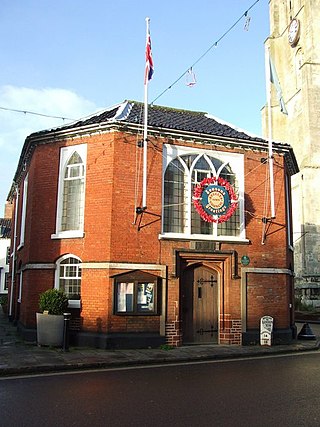
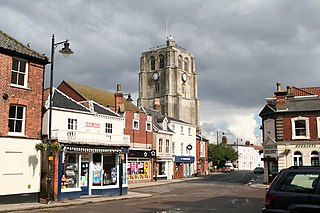
Beccles Town Hall is a municipal structure in New Market, Beccles, Suffolk, England. The structure, which accommodates the offices and meeting place of Beccles Town Council, is a Grade II listed building.

Tring Market House is a municipal building in the High Street, Tring, Hertfordshire, England. The structure, which is the meeting place of Tring Town Council, is a Grade II listed building.

Doncaster Civic Office is a municipal building in Waterdale, Doncaster, South Yorkshire, England. The structure is the meeting place of Doncaster Metropolitan Borough Council.

The Old Town Hall is a building on Church Street in the market town of Poulton-le-Fylde in Lancashire, England. The building, which is located just beyond the northern end of Market Place, started life as a public house before becoming a municipal building and then reverting to use as a public house.

Garstang Town Hall is a municipal building in the High Street in Garstang, Lancashire, England. The structure, which currently accommodates two shops and a Royal British Legion Club, is a Grade II listed building.

Kirton in Lindsey Town Hall is a municipal building in the Market Place in Kirton in Lindsey, Lincolnshire, England. The structure, which is used as the offices of Kirton in Lindsey Town Council, is a Grade II listed building.

The Old Town Hall is a former municipal building in the High Street in Wrentham, Suffolk, England. The building, which was the meeting place of Wrentham Parish Council, is a Grade II listed building.

The Shire Hall is a municipal building in Market Hill in Woodbridge, Suffolk, England. The structure, which is the meeting place of Woodbridge Town Council, is a Grade I listed building.

The Old Town Hall is a municipal building in the High Street in Needham Market, Suffolk, England. The building, which now accommodates an antiques centre and other shops, is a Grade II listed building.

Hadleigh Town Hall, also referred to as the New Town Hall, is a municipal building in the Market Place in Hadleigh, Suffolk, England. The building, which is the meeting place of Hadleigh Town Council, is a Grade II listed building.