Related Research Articles

Gettysburg National Cemetery is a United States national cemetery in Gettysburg, Pennsylvania, created for Union casualties from the Battle of Gettysburg in the American Civil War. The Battle of Gettysburg, which was fought between July 1 to 3, 1863, resulted in the largest number of casualties of any Civil War battle but also was considered the war's turning point, leading ultimately to the Union victory.

The Gettysburg Battlefield is the area of the July 1–3, 1863, military engagements of the Battle of Gettysburg in and around Gettysburg, Pennsylvania. Locations of military engagements extend from the 4-acre (1.6 ha) site of the first shot at Knoxlyn Ridge on the west of the borough, to East Cavalry Field on the east. A military engagement prior to the battle was conducted at the Gettysburg Railroad trestle over Rock Creek, which was burned on June 27.

The United States National Cemetery System is a system of 164 military cemeteries in the United States and its territories. The authority to create military burial places came during the American Civil War, in an act passed by the U.S. Congress on July 17, 1862. By the end of 1862, 12 national cemeteries had been established. Two of the nation's most iconic military cemeteries, Arlington National Cemetery which is under the jurisdiction of the Department of the Army, and Gettysburg National Cemetery, under the jurisdiction of the National Park Service, were established in 1864 and 1863, respectively.
The Peach Orchard is a Gettysburg Battlefield site at the southeast corner of the north-south Emmitsburg Road intersection with the Wheatfield Road. The orchard is demarcated on the east and south by Birney Avenue, which provides access to various memorials regarding the "momentous attacks and counterattacks in…the orchard on the afternoon of July 2, 1863."

The Gettysburg National Military Park protects and interprets the landscape of the Battle of Gettysburg, fought over three days between July 1 and July 3, 1863, during the American Civil War. The park, in the Gettysburg, Pennsylvania area, is managed by the National Park Service. Totaling 3,785 acres (1,532 ha) of area, it is mostly located in Cumberland Township, Adams County, Pennsylvania, where it takes up almost 20% of the municipality's area. Portions of the park extend into the Gettysburg borough limits, including the Soldiers' National Cemetery, and an exclave is in Mount Pleasant Township.

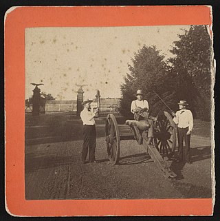
Devil's Den is a boulder-strewn hill on the end of Houck's Ridge at Gettysburg Battlefield, used by artillery and sharpshooters on the second day of the 1863 Battle of Gettysburg during the American Civil War. A tourist attraction since the memorial association era, several boulders are worn from foot traffic and the site includes numerous cannons, memorials, and walkways, including a bridge spanning two boulders.

Seminary Ridge is a dendritic ridge that served as an area of military engagements during the Battle of Gettysburg, the bloodiest battle of the American Civil War, which was fought between July 1 and July 3, 1863 in and around Gettysburg, Pennsylvania. Seminary Ridge also served as a military installation during World War II.
The high-water mark of the Confederacy or high tide of the Confederacy refers to an area on Cemetery Ridge near Gettysburg, Pennsylvania, marking the farthest point reached by Confederate forces during Pickett's Charge on July 3, 1863. Similar to a high water mark of water, the term is a reference to arguably the Confederate Army's best chance of achieving victory in the war. The line of advance was east of "The Angle" stone wall.

Rock Creek is an 18.9-mile-long (30.4 km) tributary of the Monocacy River in south-central Pennsylvania and serves as the border between Cumberland and Mount Joy townships. Rock Creek was used by the Underground Railroad and flows near several Gettysburg Battlefield sites, including Culp's Hill, the Benner Hill artillery location, and Barlow Knoll.
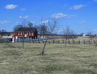
The Brian Farm is an American Civil War area of the Gettysburg Battlefield used during the Pickett's Charge. On January 23, 2004, the farm's buildings, Boundary Stone Wall, and ID tablet were designated historic district contributing structures after the tract was used for the 1918 Camp Colt and other postwar camps.
McMillan Woods is a Gettysburg Battlefield forested area used during the Battle of Gettysburg and for camps after the American Civil War, including a CCC camp and the subsequent WWII POW camp at Gettysburg. The woods includes Rifle Pits and Earth Works from the battle.
The Angle is a Gettysburg Battlefield area which includes the 1863 Copse of Trees used as the target landmark for Pickett's Charge, the 1892 monument that marks the high-water mark of the Confederacy, a rock wall, and several other Battle of Gettysburg monuments.
Emmor Cope (1834-1927) was an American Civil War officer of the Union Army noted for the "Map of the Battlefield of Gettysburg from the original survey made August to October, 1863", which he researched by horseback as a sergeant after being ordered back to Gettysburg by Maj. Gen. George G. Meade. Cope is also noted for commemorative era battlefield administration and designs, including the layout of the 1913 Gettysburg reunion. Cope had enlisted as a Private of Company A,, temporarily detached to Battery C, 5th U.S. Artillery, and mustered out as a V Corps aide-de-camp of Maj Gen Gouverneur K. Warren.

The Virginia Monument, also commonly referred to as "The State of Virginia Monument", is a Battle of Gettysburg memorial to the commonwealth's "Sons at Gettysburg" with a bronze statue of Robert E. Lee on his horse Traveller and a "bronze group of figures representing the Artillery, Infantry, and Cavalry of the Confederate Army". The equestrian statue is atop a granite pedestal and the group of six standing figures is on a sculpted bronze base with the figures facing the Field of Pickett's Charge and the equestrian statue of Union General George G. Meade on Cemetery Ridge. The granite pedestal without either sculpture was dedicated on June 30, 1913 for the 1913 Gettysburg reunion. On June 8, 1917, Virginia governor Henry C. Stuart presented the completed memorial to the public.

Tipton Station was a Gettysburg Battlefield trolley stop of the Gettysburg Electric Railway for passenger access to Crawford's Glen to the north, Devil's Den (west), and Tipton Park (east). The station was established during the 1894 construction of the end of the trolley line and was near the Devil's Den trolley siding, south of the trolley's Warren Avenue crossing, and northeast of the Plum Run trolley bridge. An uphill trail led southwest to Big Round Top with its 1895 Observation Tower, and the "Slaughter Pen Path and Steps" were built to Devil's Den.
The Gettysburg Battlefield Memorial Association (GBMA) was a historic preservation membership organization and is the eponym for the battlefield's memorial association era. The association was chartered by the Commonwealth of Pennsylvania on April 13, 1864, after attorney David McConaughy recommended on August 14, 1863, a preservation association to sell membership stock for battlefield fundraising. McConaughy transferred his land acquired in 1863 to the GBMA, and the association's boardmembers were initially local officials. The GBMA sold stock to raise money, hired a superintendent at $1000/yr, added to McConaughy's land holdings, and operated a wooden observation tower on East Cemetery Hill from 1878–95.
Monterey, Pennsylvania, is an unincorporated community which was added to the USGS Geographic Names Information System on August 2, 1979. After the site was surveyed c. 1839 for the never-completed Tapeworm Railroad, the summit community was settled on the Emmitsburg & Waynesboro Turnpike east of the Nichol's Gap Road intersection near the Toll Gate and Brown's Spring and later bypassed by the 20th century Pennsylvania Route 16 highway.

The 44th and 12th New York Infantry Monument is a Gettysburg Battlefield memorial erected near the summit of Little Round Top to commemorate combat in the Battle of Little Round Top. The castellated building is the largest monument to a regiment on the battlefield, is the 1st of only 2 Battle of Gettysburg memorials with observation decks, and supplemented the Gettysburg Battlefield Memorial Association wooden towers on Big Round Top and East Cemetery Hill. The July 3, 1893, memorial dedication was the site of an altercation against photographer William H. Tipton by Gen. Sickles, who was served a court writ the following day and was forced out of the New York Monuments Commission in 1912 after malfeasance.

Rose Woods is a Gettysburg Battlefield forested area that is an American Civil War site of the battle's Hood's Assault, McLaws' Assault, and McCandless' Advance. "Scene of the first line of Union defenses" on the Battle of Gettysburg, Second Day; the 1st Texas Infantry and 3rd Arkansas Infantry Regiments attacked Ward's 2nd Brigade line in the woods. The last combat on the Battle of Gettysburg, Third Day, was "in the early evening. Colonel William McCandless's brigade of Pennsylvania Reserves advanced across the Wheatfield into Rose's Woods where they managed to inflict heavy losses on the 15th Georgia" which had failed to retreat to Warfield Ridge after Longstreet's Assault. Two days later Timothy H. O'Sullivan photographed corpses moved for burial to the edge of Rose Woods and which were subsequently reinterred in cemeteries.

The Oak Ridge Seminary was an antebellum school for "young ladies" west of the borough of Gettysburg, Pennsylvania. One of 2 girls schools used as an American Civil War hospital for Battle of Gettysburg casualties, the female seminary had also been used as a prison, and General Lee's "Headquarters and tents [were] pitched in the space adjoining Oak Ridge Seminary"
References
- ↑ "Query Form For The United States And Its Territories". U.S. Board on Geographic Names. Retrieved 2011-06-06. "McMillan Woods (1180785)". Geographic Names Information System . United States Geological Survey, United States Department of the Interior . Retrieved 2011-06-06. Willoughby Run (1191496)
- ↑ Cope, Emmor (1920), "Spangler Woods - Cast Iron Site ID Tablet] ([http://www.hscl.cr.nps.gov/insidenps/report.asp?PARK=GETT&RECORDNO=182 Spangler House)" (NPS.gov webpage), www.hscl.cr.nps.gov, United States Department of War marker, retrieved 2011-06-06,
1 of 35 Site ID Tablets by War Dept's ... Designer ... Cope, E. B. ... Painted raised letter and border inscription tablet, 2'1"x1'8". Mounted on fluted post, 3' high.
{{citation}}: External link in|title= - ↑ "Garnett's Brigade Marker". Hmdb.org. 2008-09-30. Retrieved 2012-01-25.
| | This Adams County, Pennsylvania state location article is a stub. You can help Wikipedia by expanding it. |