
The Dolomites, also known as the Dolomite Mountains, Dolomite Alps or Dolomitic Alps, are a mountain range in northeastern Italy. They form part of the Southern Limestone Alps and extend from the River Adige in the west to the Piave Valley in the east. The northern and southern borders are defined by the Puster Valley and the Sugana Valley. The Dolomites are in the regions of Veneto, Trentino-Alto Adige/Südtirol and Friuli-Venezia Giulia, covering an area shared between the provinces of Belluno, Vicenza, Verona, Trentino, South Tyrol, Udine and Pordenone.

Lienz is a medieval town in the Austrian state of Tyrol. It is the administrative centre of the Lienz district, which covers all of East Tyrol. The municipality also includes the cadastral subdivision of Patriasdorf.

A via ferrata is a protected climbing route found in the Alps and certain other Alpine locations. The protection includes steel fixtures such as cables and railings to arrest the effect of any fall, which the climber can either hold onto or clip into using climbing protection. Some via ferrata can also include steel fixtures that provide aid in overcoming the obstacles encountered, including steel ladders and steel steps.

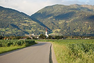
Badia is a comune (municipality) in South Tyrol, northern Italy. It is one of the five Ladin-speaking communities of the Val Badia which is part of the Ladinia region.

The Puster Valley is one of the largest longitudinal valleys in the Alps that runs in an east-west direction between Lienz in East Tyrol, Austria, and Mühlbach near Brixen in South Tyrol, Italy. The South Tyrolean municipalities of the Puster Valley constitute the Puster Valley district.

Dellach is a municipality in the district of Hermagor, in the Austrian state of Carinthia.

Mörtschach is a town in the district of Spittal an der Drau in Carinthia in Austria.

Sillian is a market town in the district of Lienz, in the Austrian state of Tyrol.

Anras is a municipality in the district of Lienz in the Austrian state of Tyrol.
Virgen is a municipality in the district of Lienz in the Austrian state of Tyrol. It includes part of the Virgen valley in the Venediger Group mountain range, and extensive parts of the municipality are in High Tauern National Park. The history of the area goes back to 500 BC, when copper mining played an important role. After the end of the Roman period Slavs settled in the Virgen valley, who were gradually assimilated by Baiuvarii settlers beginning in the 8th century. The simultaneous Christianization of the area led to the creation of one of the first parishes in the region. During the Middle Ages Virgen was a part of Carinthia and the County of Gorizia, and by 1500 it was annexed by Tyrol. With a population of 2,200, Virgen is the fifth largest community in east Tyrol in terms of population. Agriculture and tourism both play important economic roles, but a lack of jobs and structural problems lead to a very high commuter rate. Virgen has won awards for being the most beautiful municipality in Tyrol several times.
Tristach is a municipality in the district of Lienz in the Austrian state of Tyrol.
Kartitsch is a municipality in the district of Lienz in the Austrian state of Tyrol.

Obertilliach is a municipality in the district of Lienz, in the Austrian state of Tyrol.
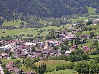
Matrei in Osttirol is a market town in the Lienz District in the Austrian state of Tyrol. It is situated about 29 km (18 mi) north of Lienz within the Hohe Tauern mountain range of the Central Eastern Alps. Its municipal area comprises parts of the Granatspitze Group and the Venediger Group, with the Großvenediger peak as its highest point. The population largely depends on tourism, seasonal agriculture and forestry.

The Villgraten Mountains or Deferegg Alps, also called the Defreggen Mountains are a subgroup of the Austrian Central Alps within the Eastern Alps of Europe. Together with the Ankogel Group, the Goldberg Group, the Glockner Group, the Schober Group, the Kreuzeck Group, the Granatspitze Group, the Venediger Group and the Rieserferner Group, the Villgraten Mountains are part of the major mountain range, the High Tauern. Their highest summit is the Weiße Spitze with a height of 2,962 m above sea level (AA).

The Gailtal Alps, is a mountain range of the Southern Limestone Alps in Austria. It rises between the River Drava (Drau) and the Gail valley and through the southern part of East Tyrol. Its western group called "Lienz Dolomites", is sometimes counted as part of this range and sometimes seen as separate.

The Lienz Dolomites are an alpine mountain range located in the Austrian states of East Tyrol and Carinthia. It lies at the western side of the wider Gailtal Alps and contains its highest peaks. The range lies between the Drau Valley in the north and the Gail Valley to the south.

The Reißkofel is, at 2,371 metres above the Adriatic (7,779 ft), the highest mountain of the Gailtal Alps east of the Lienz Dolomites. It is situated in the centre of the Gailtal range, part of the Southern Limestone Alps, in the Austrian state of Carinthia.

Hochstadel is a mountain of the Lienz Dolomites in Carinthia, Austria.
Schlossberg is a World Cup technical ski course in Austria on Lienz Dolomites above Lienz, Tyrol, the race course debuted in 1969. It is part of Hochstein Ski Resort.

