Spodnje Grušovje | |
---|---|
Coordinates: 46°20′46.3″N15°30′2.12″E / 46.346194°N 15.5005889°E Coordinates: 46°20′46.3″N15°30′2.12″E / 46.346194°N 15.5005889°E | |
Country | ![]() |
Traditional region | Styria |
Statistical region | Savinja |
Municipality | Slovenske Konjice |
Area | |
• Total | 2.83 km2 (1.09 sq mi) |
Elevation | 339.5 m (1,113.8 ft) |
Population (2002) | |
• Total | 192 |
[1] |
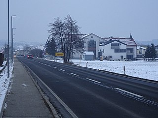
Spodnje Grušovje (pronounced [ˈspoːdnjɛ ˈɡɾuːʃɔu̯jɛ] ) is a settlement in the Municipality of Slovenske Konjice in eastern Slovenia. The area is part of the traditional region of Styria. The municipality is now included in the Savinja Statistical Region. The A1 Slovenian motorway runs through the settlement. [2]
A municipality is usually a single urban administrative division having corporate status and powers of self-government or jurisdiction as granted by national and regional laws to which it is subordinate. It is to be distinguished (usually) from the county, which may encompass rural territory or numerous small communities such as towns, villages and hamlets.
Slovenske Konjice is a town and a municipality in northeastern Slovenia. The area was part of the traditional region of Styria.
Slovenia, officially the Republic of Slovenia, is a sovereign state located in southern Central Europe at a crossroads of important European cultural and trade routes. It is bordered by Italy to the west, Austria to the north, Hungary to the northeast, Croatia to the southeast, and the Adriatic Sea to the southwest. It covers 20,273 square kilometers (7,827 sq mi) and has a population of 2.07 million. One of the successor states of the former Yugoslavia, Slovenia is a parliamentary republic and a member of the United Nations, of the European Union, and of NATO. The capital and largest city is Ljubljana.
A Roman-era mansio known as Mansio Ragando on the road from Celeia to Poetovio has been identified in the settlement. [3]
In historiography, ancient Rome is Roman civilization from the founding of the city of Rome in the 8th century BC to the collapse of the Western Roman Empire in the 5th century AD, encompassing the Roman Kingdom, Roman Republic and Roman Empire until the fall of the western empire. The civilization began as an Italic settlement in the Italian peninsula, dating from the 8th century BC, that grew into the city of Rome and which subsequently gave its name to the empire over which it ruled and to the widespread civilisation the empire developed. The Roman empire expanded to become one of the largest empires in the ancient world, though still ruled from the city, with an estimated 50 to 90 million inhabitants and covering 5.0 million square kilometres at its height in AD 117.
In the Roman Empire, a mansio was an official stopping place on a Roman road, or via, maintained by the central government for the use of officials and those on official business whilst travelling.
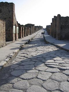
Roman roads were physical infrastructure vital to the maintenance and development of the Roman state, and were built from about 300 BC through the expansion and consolidation of the Roman Republic and the Roman Empire. They provided efficient means for the overland movement of armies, officials, and civilians, and the inland carriage of official communications and trade goods. Roman roads were of several kinds, ranging from small local roads to broad, long-distance highways built to connect cities, major towns and military bases. These major roads were often stone-paved and metaled, cambered for drainage, and were flanked by footpaths, bridleways and drainage ditches. They were laid along accurately surveyed courses, and some were cut through hills, or conducted over rivers and ravines on bridgework. Sections could be supported over marshy ground on rafted or piled foundations.
Blato may refer to the following places:
Spodnje Laže is a settlement in the Municipality of Slovenske Konjice in eastern Slovenia. It lies on the left bank of the Dravinja River. The railway line from Celje to Pragersko runs through the settlement. The area is part of the traditional region of Styria. The municipality is now included in the Savinja Statistical Region.
Zgornje Laže is a small settlement in the Municipality of Slovenske Konjice in eastern Slovenia. It lies in the hills north of Spodnje Laže. Traditionally the area was part of Styria. The entire municipality is now included in the Savinja Statistical Region.
Bezina is a settlement in the Municipality of Slovenske Konjice in eastern Slovenia. It lies on the regional road leading north from Slovenske Konjice to Oplotnica. The area is part of the traditional region of Styria. The municipality is now included in the Savinja Statistical Region.
Blato is a small settlement in the Municipality of Slovenske Konjice in eastern Slovenia. It lies under the northeastern slopes of Mount Konjice, just southeast of Slovenske Konjice itself. The area is part of the traditional region of Styria. The municipality is now included in the Savinja Statistical Region.
Brdo is a settlement in the Municipality of Slovenske Konjice in eastern Slovenia. Traditionally the entire area around Slovenske Konjice was part of Styria. It is now included in the Savinja Statistical Region.
Gabrovlje is a settlement on the left bank of the Dravinja River north of Slovenske Konjice in eastern Slovenia. The area is part of the traditional region of Styria. The entire Municipality of Slovenske Konjice is now included in the Savinja Statistical Region of Slovenia.
Gabrovnik is a settlement in the Municipality of Slovenske Konjice in eastern Slovenia. It lies in the hills northeast of Slovenske Konjice. The area is part of the traditional region of Styria. The municipality is now included in the Savinja Statistical Region.
Lipoglav is a settlement in the hills south of Loče in the Municipality of Slovenske Konjice in eastern Slovenia. The area was traditionally part of Styria. The entire Municipality of Slovenske Konjice is now included in the Savinja Statistical Region of Slovenia.
Konjiška Vas is a settlement in the Municipality of Slovenske Konjice in eastern Slovenia. It lies at the foot of the eastern end of the Mount Konjice hills southeast of Slovenske Konjice. The area is part of the traditional region of Styria. The municipality is now included in the Savinja Statistical Region.
Prežigal is a small settlement in the Municipality of Slovenske Konjice in eastern Slovenia. It lies on the left bank of the Dravinja River east of Slovenske Konjice itself. Traditionally the area was part of Styria. The municipality is now included in the Savinja Statistical Region.
Ostrožno pri Ločah is a small dispersed settlement in the hills south of Loče in the Municipality of Slovenske Konjice in eastern Slovenia. It lies on the left bank of the Dravinja River. The area is part of the traditional region of Styria. The municipality is now included in the Savinja Statistical Region.
Sojek is a small settlement in the Municipality of Slovenske Konjice in eastern Slovenia. It lies dispersed on the southern slopes of the Mount Konjice hills southwest of Slovenske Konjice. The area of the entire Municipality of Slovenske Konjice was traditionally part of the Styria region and is now included in the Savinja Statistical Region.
Spodnje Preloge is a settlement in the Municipality of Slovenske Konjice in eastern Slovenia. It lies between Koprivnica and Polenščica creeks, right tributaries of the Dravinja River west of Slovenske Konjice. The area is part of the traditional region of Styria. The municipality is now included in the Savinja Statistical Region.
Stare Slemene is a settlement in the Municipality of Slovenske Konjice in eastern Slovenia. The area is part of the traditional region of Styria. The municipality is now included in the Savinja Statistical Region.
Strtenik is a small settlement in the hills north of Slovenske Konjice in eastern Slovenia. The area is part of the traditional region of Styria. The entire Municipality of Slovenske Konjice is now included in the Savinja Statistical Region.
Škalce is a settlement in the Municipality of Slovenske Konjice in eastern Slovenia. It lies in the hills just north of Slovenske Konjice itself. The area is part of the traditional region of Styria. The municipality is now included in the Savinja Statistical Region.
Tepanje is a village in the Municipality of Slovenske Konjice in eastern Slovenia. The area is part of the traditional region of Styria. The municipality is now included in the Savinja Statistical Region.
Tolsti Vrh is a settlement in the Municipality of Slovenske Konjice in eastern Slovenia. It lies on the southern slopes of the Mount Konjice hills south of the town of Slovenske Konjice. The area is part of the traditional region of Styria. The municipality is now included in the Savinja Statistical Region.
Vešenik is a settlement in the Municipality of Slovenske Konjice in eastern Slovenia. It lies in the hills immediately northeast of Slovenske Konjice. The area is part of the traditional region of Styria. When statistical regions were created in Slovenia in 2007, the Municipality of Slovenske Konjice was included in the Savinja Statistical Region.
![]() | This article about the Municipality of Slovenske Konjice in Slovenia is a stub. You can help Wikipedia by expanding it. |