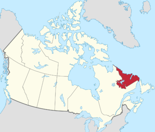
Newfoundland and Labrador is the easternmost province of Canada, in the country's Atlantic region. The province comprises the island of Newfoundland and the continental region of Labrador, having a total size of 405,212 square kilometres. In 2021, the population of Newfoundland and Labrador was estimated to be 521,758. The island of Newfoundland is home to around 94 per cent of the province's population, with more than half residing in the Avalon Peninsula. Labrador borders the province of Quebec, and the French overseas collectivity of Saint Pierre and Miquelon lies about 20 km west of the Burin Peninsula.

The Hudson Strait links the Atlantic Ocean and the Labrador Sea to Hudson Bay in Canada. This strait lies between Baffin Island and Nunavik, with its eastern entrance marked by Cape Chidley in Newfoundland and Labrador and Resolution Island off Baffin Island. The strait is about 750 km long with an average width of 125 km, varying from 70 km at the eastern entrance to 240 km at Deception Bay.

Labrador is a geographic and cultural region within the Canadian province of Newfoundland and Labrador. It is the primarily continental portion of the province and constitutes 71% of the province's area but is home to only 6% of its population. It is separated from the island of Newfoundland by the Strait of Belle Isle. It is the largest and northernmost geographical region in the four Atlantic provinces.

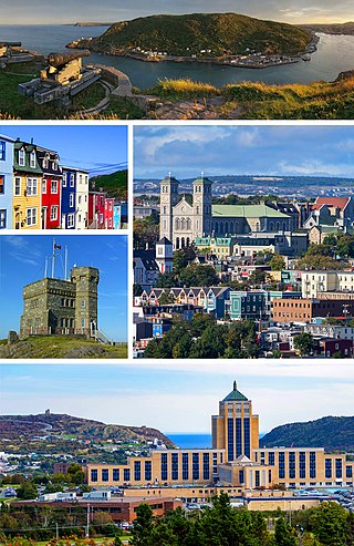
St. John's is the capital and largest city of the Canadian province of Newfoundland and Labrador, located on the eastern tip of the Avalon Peninsula on the island of Newfoundland.

British North America comprised the colonial territories of the British Empire in North America from 1783 onwards. English colonisation of North America began in the 16th century in Newfoundland, then further south at Roanoke and Jamestown, Virginia, and more substantially with the founding of the Thirteen Colonies along the Atlantic coast of North America.

Corner Brook is a city located on the west coast of the island of Newfoundland in the province of Newfoundland and Labrador, Canada. Corner Brook is the fifth largest settlement in Newfoundland and Labrador.

The Labrador Sea is an arm of the North Atlantic Ocean between the Labrador Peninsula and Greenland. The sea is flanked by continental shelves to the southwest, northwest, and northeast. It connects to the north with Baffin Bay through the Davis Strait. It is a marginal sea of the Atlantic.

Nain is the northernmost permanent settlement in the Canadian province of Newfoundland and Labrador, within the Nunatsiavut region, located about 370 km (230 mi) by air from Happy Valley-Goose Bay. The town was established as a Moravian mission in 1771 by Jens Haven and other missionaries. As of 2021, the population is 1,204 mostly Inuit and mixed Inuit-European. Nain is the administrative capital of the autonomous region of Nunatsiavut.

Bell Island is an island that is part of Newfoundland and Labrador, Canada's easternmost province. With an area of 34 km2, it is by far the largest island in Conception Bay, a large bay in the southeast of the island of Newfoundland. The provincial capital of St. John's is less than 20 km to the east.

Torbay is a town located on the eastern side of the Avalon Peninsula in Newfoundland and Labrador, Canada.

The American Theater was a theater of operations during World War II including all continental American territory, and extending 200 miles (320 km) into the ocean.
Ramea is a small village in Newfoundland and Labrador located on Northwest Island, one of a group of five major islands located off the south coast of Newfoundland, Canada. The island is approximately 3.14 km long by 0.93 km wide. The other major islands in the archipelago are Great Island, Middle Island, Harbour Island, and South West Island.
Tors Cove is a local service district and designated place in the Canadian province of Newfoundland and Labrador. It is on the east coast of the Avalon Peninsula of the island of Newfoundland, approximately 40 kilometres south of the St. John's, the provincial capital, along Route 10. It was formerly named Toads Cove.

The history of post-confederation Canada began on July 1, 1867, when the British North American colonies of Canada, New Brunswick, and Nova Scotia were united to form a single Dominion within the British Empire. Upon Confederation, the United Province of Canada was immediately split into the provinces of Ontario and Quebec. The colonies of Prince Edward Island and British Columbia joined shortly after, and Canada acquired the vast expanse of the continent controlled by the Hudson's Bay Company, which was eventually divided into new territories and provinces. Canada evolved into a fully sovereign state by 1982.
William's Harbour is a former local service district and designated place in the Canadian province of Newfoundland and Labrador. The community was entirely resettled in 2017. The settlement was part of the NunatuKavut territory.
Burgoyne's Cove is a local service district and designated place in the Canadian province of Newfoundland and Labrador.

Brig Bay is a local service district and designated place in the Canadian province of Newfoundland and Labrador. It was first mapped by Captain James Cook in September 1764. The name "Brig" was adopted by the French who occupied the bay prior to English occupation. It provided a safe and well-sheltered harbour.

Newfoundland is a large island off the east coast of the North American mainland and the most populous part of the Canadian province of Newfoundland and Labrador. It has 29 percent of the province's land area. The island is separated from the Labrador Peninsula by the Strait of Belle Isle and from Cape Breton Island by the Cabot Strait. It blocks the mouth of the Saint Lawrence River, creating the Gulf of Saint Lawrence, the world's largest estuary. Newfoundland's nearest neighbour is the French overseas collectivity of Saint Pierre and Miquelon.

William Jackman was a Newfoundland sealing captain and sailing master.
Island of Ponds is an island off of the east coast of Labrador. The Labrador mainland lies to its south and a channel called Domino Run separates it from Spotted Island to the north. The only remaining settlement on the island is Black Tickle. It is connected to the mainland by a seasonal coastal ferry service.


