St. Margaret's Bay Hydroelectric System

Last updated

St. Margaret's Bay Hydroelectric System
Nova Scotia DSC03206 - Mill Lake Hydro Plant (8475686279).jpg
Mill Lake Hydro Plant
Nova Scotia topographic map.png
Red pog.svg
Location of second of two power stations
Canada relief map 2.svg
Red pog.svg
St. Margaret's Bay Hydroelectric System (Canada)
CountryCanada
Location Halifax Regional Municipality, Nova Scotia
Coordinates 44°41′29″N63°53′30″W / 44.69145°N 63.8917°W / 44.69145; -63.8917
Purpose Power
StatusOperational
Construction beganMay 1920
Construction cost$1,700,000 [1]
Built byD.G. Loomis & Sons [1]
Designed byC.H. & P.H. Mitchell, of Toronto
Owner(s) Emera
Operator(s) Nova Scotia Power
Upper reservoir
CreatesMill Lake & Sandy Lake
Total capacity101,145,000 m3 (82,000 acre⋅ft) [2]
Active capacity89,180,700 m3 (72,300 acre⋅ft) [2]
Catchment area 271 square kilometres (105 sq mi) [3]
Normal elevationMill Lake 77.4 m (253.9 ft), Sandy Lake 66 m (216.5 ft)
Lower reservoir
CreatesMill Lake Head Pond
Normal elevation27.9 m (91.5 ft)
Mill Lake, Sandy Lake & Tidewater Plants
Coordinates 44°41′29″N63°53′29″E / 44.691384°N 63.891380°E / 44.691384; 63.891380
Commission date8 June 1922
Type Conventional
Hydraulic head Mill Lake 50 m (164.04 ft), Sandy Lake 38 m (124.67 ft), Tidewater 27.9 m (91.54 ft) [2]
Turbines 2 x 6 MW + 2 x 2.9 MW [4]
Installed capacity 10.2 MW [3]
Annual generation 30  GWh [4]
Website
www.nspower.ca

The St. Margaret's Bay Hydroelectric System consists of three hydroelectric power plants (two collocated in the same building) and the related lake, dam, and river systems driving them. The system is situated within both Lunenburg County and the Halifax Regional Municipality, beginning approximately 2.5 km (1.6 mi) east of the Head of Saint Margarets Bay and approximately 10 km (6.2 mi) southwest of Hammonds Plains. The system is part of the East Indian River watershed and drains 271 square kilometres (105 sq mi), with water storage provided in Lunenburg County by Mill Lake, Coon Pond, Sandy Lake, Wrights Lake, Big Indian Lake, Five Mile Lake and, at times, an overflow from Pockwock Lake in the Halifax Regional Municipality. The system is owned and operated by Nova Scotia Power Inc.

Contents

System assets associated with the St. Margaret's Bay Hydro System, which represents six generating units with an operating capacity of 10.2 MW, include Beeswanger Dam, Five Mile Dam and Wing Dam 4, Mack Lake Main Dam, Five Mile Wing Dams 1,2 and 3, Big Indian Dam, Wright's Lake Dam, Coon Pond Dam, Sandy Lake Dam, Sandy Lake and Coon Pond Pipeline, Mill Lake Plant and Surge Tank, Little Indian Crossover, Mill Lake Dam, Tidewater Plant and Surge Tank, Tidewater Pipeline, as well as associated headponds. Outflow is into St. Margarets Bay, Nova Scotia between Head of St. Margarets Bay and Tantallon.

Commissioned 8 June 1922, St. Margaret's Bay Hydroelectric System is the oldest hydro plant in Nova Scotia.

Technical characteristics

Dams, Wing Dams, Spillways, and Canals

There are 19 dams and wing dams of various heights, lengths and construction types holding back the lakes and reservoirs that make up the St. Margaret's Bay Hydroelectric System: [3]

Dam or other Structure [3] Height (ft.) [3] Length (ft.) [3] Foundation [3] Type [3]
Coon Pond Dam and Spillway32408Constructed on bedrockConcrete & Earthfill
Sandy Lake Dam and Spillway50.51,021Constructed on bedrockConcrete & Earthfill
Big Indian Spillway25.1430Constructed on bedrockConcrete
Big Indian Main Dam (Concrete)37.9470Constructed on bedrockConcrete
Big Indian Main Dam (Earthfill)33.3120Constructed on bedrockConcrete & Earthfill
Big Indian Wing Dam No. 1475
Big Indian Wing Dam No. 22.585
Five Mile Lake Main Dam14.5695Constructed on bedrockConcrete
Mack Lake Dam20410Earthfill
Five Mile Lake Wing Dam No. 16200Freeboard damEarthfill
Five Mile Lake Wing Dam No. 24165Freeboard damEarthfill
Five Mile Lake Wing Dam No. 34105Freeboard damEarthfill
Five Mile Lake Wing Dam No. 410500Freeboard damConcrete
Beeswanger Dam8460Freeboard damEarthfill
Wrights Lake Dam and spillway17326Concrete & Earthfill
Wrights Lake Wing Dam No. 1420
Wrights Lake Wing Dam No. 23.520
Wrights Lake Wing Dam No. 3535
Little Indian Lake Cross-over Control Structure4170Constructed on bedrockConcrete & Earthfill
Mill Lake Head Pond Dam (Tidewater Plant)20830Constructed on bedrockConcrete & Earthfill

Water for the system comes from Five Mile Lake, Big Indian Lake, Sandy Lake, Wrights Lake, Coon Pond, Mill Lake and, at times, overflow from Pockwock Lake. The two principal storage areas for the Sandy Lake Development are Five Mile Lake and Big Indian Lake.

On the Eastern side of the system, drainage into Wright's Lake and Coon Pond, in addition to surplus water from Pockwock Lake (owned by Halifax Regional Municipality), supplies the Mill Lake Plant. The new Coon Pond Dam has water continually flowing out from a maintenance chute to ensure water is always feeding a stream leading to St. Margaret's Bay to maintain fish habitat in the stream.

Output water from the Sandy Lake and Mill Lake plants then flow into the Mill Lake Head Pond to supply the Tidewater Plant which outputs at sea level into St. Margaret's Bay.

The total elevation from the highest reservoir to sea level is 134.2 m (440 ft). [4] The St. Margaret's Bay Hydroelectric System has an annual output of 30 Gigawatt hours of electricity from two .6 MW generators at Mill Lake and two 2.9 MW generators at the Tidewater plant. [4]

The Generators were made by General Electric Co limited from Peterborough, Toronto, Ontario, Canada. Nova Scotia DSC03226 - Generators (8475707265).jpg
The Generators were made by General Electric Co limited from Peterborough, Toronto, Ontario, Canada.

Mill Lake Generating Station

Located on the Northeast River. Two vertical francis turbine units, shaft direct connected to the generators, with individual direct connected exciters, 49.5 m (162.4 ft) static head, 514 rpm, 1.42 MW (1,904 hp), for a total of 3.73 MW (5,000 hp). Two generators, 1,600 kVA each, 13,200 volts, 3 phase, 60 Hz. The original penstocks were built out of wood, using tongue & groove staves held together with metal bands (the same technology used in wood barrels), 1.82 m (6 ft) diameter, 965.6 m (3,168 ft) long, later replaced in part with fibreglass penstocks. [2] More recently (2010) the penstocks from Coon Pond to the Mill Lake Station were replaced with black polypropylene, buried underground.

Sandy Lake Generating Station

Sandy Lake Generating Station was added to the system in 1927. The power house was built beside the Mill Lake Plant. [1] Two vertical francis turbine units, shaft direct connected to the generators, with motor generator set excitation, 38.1 m (125.0 ft) static head, 514 rpm, 1.86 MW (2,494 hp), for a total of 2.84 MW (3,810 hp). Two generators, 2,000 kVA each, 13,200 volts, 3 phase, 60 Hz. [2] The original Penstocks were built out of wood tongue & groove staves with metal bands, 2.43 m (8 ft) diameter, 1,756.5 m (5,763 ft) long, later replaced in part with fibreglass penstocks.

Tidewater Generating Station

Located on the shores of St. Margaret's Bay. Two vertical francis turbine units, shaft direct connected to the generators, with individual direct connected exciters, 27.9 m (91.5 ft) static head, 300 rpm, 2.57 MW (3,446 hp), for a total of 5.14 MW (6,890 hp). Two generators, 3,900 kVA each, 13,200 volts, 3 phase, 60 Hz. [2] The original Penstocks were built out of wood tongue & groove staves with metal bands, 3 m (10 ft) diameter, 909.2 m (2,983 ft) long, later replaced in part with fibreglass penstocks.

2012 Upgrade

The system was upgraded in 2012 with $17.8 million of work to replace the old wooden penstocks in fibreglass, a new water surge tank, a new dam at Mill Lake, a new gatehouse and gate at Mill Lake, and new floating booms to keep debris away from the dams.

2016 Surge Tank replacement

The original 43.9 m (144 ft) tall Sandy Lake Surge Tank was installed in 1927, and refurbished in 1996. In 2016 it was replaced with a new Surge Tank made of steel and fiberglass. [5]

Restoration of Fish Habitat

Gaspereau have returned to Indian River on the St. Margaret's Bay Hydro System for the first time in well over 100 years.

On 16 May 16 1881, an inspector with the then federal Department of Marine and Fisheries toured the St. Margaret's Bay watershed and noted the lack of fish because dams used for running and milling logs did not have fish ladders.

In 2015 Nova Scotia Power invested $4 million into building the largest fish ladder in Nova Scotia at the Sandy Lake Dam.

On 17 May 2016 - 135 years and one day after the federal inspector had been there - a field biologist with Nova Scotia Power checked the ladder and spotted three gaspereau in the resting pools.

“It’s awesome, it’s absolutely awesome,” said Darcy Pettipas, the senior environmental technologist who for two weeks had been checking the ladder for signs of the fish. He'd seen speckled trout and smallmouth bass, but no gaspereau.

Pettipas was working on another project the day the biologist saw the three gaspereau. He headed out to the fish ladder the next day and dipped his underwater live view camera into the fishway. It turns out there were so many gaspereau he didn't need the camera.

“We saw many gaspereau throughout the ladder as well as speckled trout, smallmouth bass and a white sucker,” Pettipas said.
“We weren’t sure if the gaspereau would come back or not,” said senior environmental scientist Jay Walmsley. That's because it had been generations since gaspereau last spawned in this river system.

The intent of the ladder is to ensure the passage of species of fish that have to migrate to fulfill their life cycles, such as gaspereau and the endangered Southern Upland Atlantic salmon. Gaspereau swim up the river in the spring to spawn in the still waters of the lake then swim back to sea in the fall.

“Gaspereau tend to go back to spawn in the same river that they’re used to. They imprint on the steam on their way out, and when they come back to spawn, most go up the river they were born in,” Walmsley said.

But it seems the new fish ladder, through both its design and the 30 cubic feet per second of water that flows through it, created enough white, bubbly water in the river to attract some of the fish to the ladder.

From the ladder, the fish will make their way to Sandy Lake.

“Gaspereau are important because they bring nutrients from the ocean and the more different types of fish we have in the system, the greater the diversity and productivity, and the healthier the system,” Walmsley said. “They are very beneficial to the ecosystem.”

Walmsley said this success holds tremendous potential. It's hoped the fish will eventually extend to the whole catchment area of the Indian River. [6]

Related Research Articles

The Lake Margaret Power Stations comprise two hydroelectric power stations located in Western Tasmania, Australia. The power stations are part of the King – Yolande Power Scheme and are owned and operated by Hydro Tasmania. Officially the Upper Lake Margaret Power Station, a conventional hydroelectric power station, and the Lower Lake Margaret Power Station, a mini-hydroelectric power station, the stations are generally collectively referred to in the singular format as the Lake Margaret Power Station. The stations are located approximately 2.5 kilometres (1.6 mi) apart.

The Temengor Dam or Temengor Hydro-Electric Project or Temengor Power Station is a dam in Gerik, Perak, Malaysia. It is located on Perak River about 200 km northeast of Ipoh. Construction of the dam impounded Temenggor Lake.

The Lake Echo Power Station is a conventional hydroelectric power station located in the Central Highlands region of Tasmania, Australia. The power station is situated on the Upper River Derwent catchment and is owned and operated by Hydro Tasmania.

Kakabeka Generating Station is a hydroelectric facility operated by Ontario Power Generation on the bank of the Kaministiquia River, 2 km (1.2 mi) downstream from Kakabeka Falls in the community of Kakabeka Falls, Ontario, 30 km (19 mi) west of Thunder Bay. The plant provides energy to the city of Thunder Bay and area. The station is one of ten hydroelectric stations in Ontario Power Generation's Northwest Plant Group, and is remotely operated from Thunder Bay.

Lotru-Ciunget Dam and Hydro Power Plant is a large hydroelectric complex on the river Lotru situated in Romania and one of the biggest complex facilities in Europe. The complex consists of three hydroelectric power plants. The first and most productive one is Ciunget, the second one is Malaia and the third one is Bradisor which, just as Ciunget is an underground power plant.

<span class="mw-page-title-main">Gaspereau Lake</span>

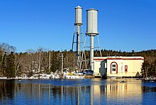
Gaspereau Lake is a lake in Kings County, Nova Scotia, Canada, about 10 km south of the town of Kentville, Nova Scotia on the South Mountain. It is the largest lake in Kings County, and the fifth largest lake in Nova Scotia. The lake is shallow with dozens of forested islands and hundreds of rocky islets (skerries).

<span class="mw-page-title-main">Ruskin Dam and Powerhouse</span> Dam in Ruskin, British Columbia

Ruskin Dam is a concrete gravity dam on the Stave River in Ruskin, British Columbia, Canada. The dam was completed in 1930 for the primary purpose of hydroelectric power generation. The dam created Hayward Lake, which supplies water to a 105 MW powerhouse and flooded the Stave's former lower canyon, which ended in a small waterfall approximately where the dam is today.

<span class="mw-page-title-main">Stave Falls Dam and Powerhouse</span> Dam in Stave Falls

Stave Falls Dam is a dual-dam power complex on the Stave River in Stave Falls, British Columbia, Canada. The dam was completed in 1912 for the primary purpose of hydroelectric power production. To increase the capacity of Stave Lake, the dam was raised in 1925 and the Blind Slough Dam constructed in an adjacent watercourse 500 m (1,600 ft) to the north, which was the site of the eponymous Stave Falls. In 2000, the dam's powerhouse was replaced after a four-year upgrade. The original Stave Falls powerhouse was once British Columbia's largest hydroelectric power source, and is a National Historic Site of Canada.

<span class="mw-page-title-main">Edolo Pumped Storage Plant</span> Dam in Edolo

The Edolo Pumped Storage Plant is located along the Oglio River just downstream of Edolo, Brescia Province in the Lombardy region of Italy. Using the pumped-storage hydroelectric method, it has an installed capacity of 1,000 megawatts (1,300,000 hp). Its generators were commissioned between April 1984 and November 1985. Lake Avio was previously completed in 1929 and Lake Benedetto completed in 1940.

The Upper Cisokan Pumped Storage Plant is a proposed pumped-storage hydropower facility in Indonesia, due for completion by 2025.

<span class="mw-page-title-main">Gaspereau River</span> River in Nova Scotia, Canada

The Gaspereau River is a river in Kings County, Nova Scotia, Canada.

<span class="mw-page-title-main">Eklutna Dam</span> Dam in Anchorage, Alaska

The Eklutna Dam, also referred to as the New Eklutna Dam or Upper Eklutna Dam, is an embankment dam on the Eklutna River about 30 mi (48 km) northeast of Anchorage in Alaska, United States. The primary purpose of the dam is hydroelectric power generation and it supports a 47 MW power plant. It was first completed in 1929 but was rehabilitated or rebuilt on several occasions over its history. Ownership of the dam and power plant is shared by Chugach Electric and Matanuska Electric.

<span class="mw-page-title-main">Escaldes Hydroelectric Power Station</span> Dam in Engolasters, Encamp

Escaldes Hydroelectric Power Station is located in Engolasters of the Encamp parish in Andorra. Its namesake, Les Escaldes, is located just to the south in Escaldes-Engordany parish. It uses water from Lake Engolasters, located 1,616 metres (5,302 ft) above sea level in order to generate hydroelectricity. A 1,250 metres (4,100 ft) long penstock deliver water from the 178 m (584 ft) long Engolasters Dam to the power station which contains two 14 MW and one 17 MW Pelton turbine-generators. The difference in elevation between the lake and power station is about 490 metres (1,610 ft).

<span class="mw-page-title-main">Snoqualmie Falls Hydroelectric Plant</span>

The Snoqualmie Falls Hydroelectric Plant is located just north of Snoqualmie in King County, Washington state, US. It is situated about 22 mi (35 km) east of Seattle. Located just below the Snoqualmie Falls, the power plant consists of two power houses, Plant 1 and Plant 2. Plant 1 was completed in 1899 and is located underground. It is the first completely underground hydroelectric power plant ever built in the world. Plant 2 was built in 1910 and is located along the right bank of the Snoqualmie River. Both plants receive water from a small reservoir created by a weir atop the falls. Plant 1 has an installed capacity of 13.7 MW and Plant 2 a capacity of 40.2 MW for a total installed capacity of 53.9 MW, enough to power 40,000 homes.

<span class="mw-page-title-main">Vorotan Cascade</span> Dam in Syunik Province

The Vorotan Cascade, or the ContourGlobal™ Hydro Cascade, is a cascade on the Vorotan River in Syunik Province, Armenia. It was built to produce hydroelectric power and provide irrigation water. The Vorotan Cascade consists of three hydroelectric power plants and five reservoirs with a combined installed capacity of 404.2 MW. It is one of the main power generation complexes in Armenia.

The Moragolla Dam is a planned hydroelectric dam in Moragolla, Sri Lanka. The dam is to be 35 m (115 ft) high and is planned to create the 1,980,000 m3 (70,000,000 cu ft) Moragolla Reservoir with a maximum supply level at 548 m (1,798 ft) MSL. Upon completion, the Moragolla Power Station would have a gross installed capacity of 30 megawatts from two francis turbines, capable of generating approximately 85 GWh annually.

Wreck Cove is the largest hydroelectric system in Nova Scotia with a generating capacity of 215.8 MW. Constructed from 1975 to 1978, south of the Cape Breton Highlands National Park, Wreck Cove collects drainage water from 216 square kilometres (83 sq mi) of the Cape Breton Highlands plateau to generate renewable electricity. It consists of two generating stations: the Gisborne Generating Station, with an installed capacity of 3.5 MW, and the Wreck Cove Generating Station, with an installed capacity of 212 MW, producing on average 318 GWh annually—enough energy to power about 30,000 homes.

The Motukawa Power Station is a hydroelectric power facility in Taranaki in New Zealand which makes use of water from the Manganui River and Waitara River catchments. Water is drawn from behind a weir on the Manganui River near Tariki and diverts this water through a race to Lake Ratapiko and then through penstocks to the Motukawa Power Station. The power station discharges into the Mākara Stream, a tributary of the Waitara River.

St. Anthony Falls in Minneapolis, Minnesota, is the only natural falls on the Mississippi River. Since almost the beginning of settlement in the area by European descendants, the St. Anthony Falls have been used for waterpower. The first allowed settlers were at Ft. Snelling, where construction began in 1820. A sawmill was operating 1821 and a flour mill in 1823. As soon as the land at the sides of the falls became available it was purchased with the intent of using the waterpower of the falls. First lumber mills covered the falls, cutting lumber floated down the Mississippi. After 1870 flour mills started to dominate the area. From 1880 to 1930 the area was the number one flour producer in the US. In later years, some of the power came from steam, but in 1923 half of the waterpower used was for flour milling. Other industries have also used the waterpower.

References

  1. 1 2 3 Ford, Tim. "St.Margarets Bay Hydro-electricity Plants, Green Renewable Power Since 1922". www.st-margaretsbay.com. Retrieved 9 April 2020.
  2. 1 2 3 4 5 6 Eleventh Annual Report - Nova Scotia Power Commission. Halifax, NS: Nova Scotia Power Commission. 1930. p. 11. Retrieved 8 April 2020.
  3. 1 2 3 4 5 6 7 8 "Nova Scotia Power Incorporated Hydro Asset Study" (PDF). Nova Scotia Power 2020 Integrated Resource Plan. Nova Scotia Power Inc. 21 December 2018. p. 52. Retrieved 5 April 2020.
  4. 1 2 3 4 Ayling, Keith (18 June 2014). "St Margaret's Bay Power Plant Opens its System to Public" (PDF). Masthead News. p. 12. Retrieved 16 November 2014.
  5. Ayling, Keith (25 May 2016). "New Tower Replacing 89-Year-Old Surge Tank at Mill Lake Powerhouse Near Tantallon" (PDF). The Masthead News. Vol. 28, no. 5. Ocean Breeze Distributions. pp. 1–2. Retrieved 9 April 2020.
  6. "Swimming against the current: more than a century later, gaspereau are back". Press Release. Nova Scotia Power. 24 May 2016. Retrieved 9 April 2020.