St. Marys Township, Adams County, Indiana

Last updated

Saint Marys Township
Ben Colter Polygonal Barn.jpg
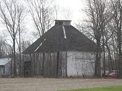
The Ben Colter Polygonal Barn, a historic site in the township
Map highlighting Saint Marys Township, Adams County, Indiana.svg
Location within Adams County
Coordinates: 40°47′20″N84°50′42″W / 40.78889°N 84.84500°W / 40.78889; -84.84500
Country Flag of the United States (23px).png  United States
State Flag of Indiana.svg  Indiana
County Adams
Government
  Type Indiana township
Area
  Total
24.58 sq mi (63.7 km2)
  Land24.57 sq mi (63.6 km2)
  Water0.01 sq mi (0.03 km2)  0.04%
Elevation
784 ft (239 m)
Population
 (2020) [1]
  Total
1,269
  Density53.2/sq mi (20.5/km2)
Time zone UTC-5 (Eastern (EST))
  Summer (DST) UTC-4 (EDT)
ZIP code
46733
Area code 260
GNIS feature ID 453821

Saint Marys Township is one of twelve townships in Adams County, Indiana. [2] As of the 2020 census, its population was 1,269, [1] down from 1,308 at the 2010 census. [3]

Contents

Geography

According to the 2010 census, the township has a total area of 24.58 square miles (63.7 km2), of which 24.57 square miles (63.6 km2) (or 99.96%) is land and 0.01 square miles (0.026 km2) (or 0.04%) is water. [4]

Unincorporated towns

Major highways

Rivers

School districts

Political districts

References

  1. 1 2 "Census Bureau profile: St. Marys Township, Adams County, Indiana". United States Census Bureau. May 2023. Retrieved March 27, 2024.
  2. "Saint Marys Township, Adams County, Indiana". Geographic Names Information System . United States Geological Survey . Retrieved February 15, 2020.
  3. "Geographic Identifiers: 2010 Demographic Profile Data (G001): St. Marys township, Adams County, Indiana". U.S. Census Bureau, American Factfinder. Archived from the original on February 12, 2020. Retrieved May 8, 2013.
  4. 2002 Census of Governments, Individual State Descriptions (PDF)