
Gower electoral ward is an electoral ward in Britain. It is a ward of the City and County of Swansea, and comprises the western part of the Gower Peninsula. It lies within the UK Parliamentary constituency of Gower.

Merthyr Mawr is a village and community in Bridgend, Wales. The village is about 2+1⁄2 miles from the centre of Bridgend town. The population of the community at the 2011 census was 267. The community occupies the area west of the Ewenny River, between Bridgend and Porthcawl. It takes in the settlement of Tythegston and a stretch of coastal sand dunes known as Merthyr Mawr Warren. It is in the historic county of Glamorgan.

Saint Cadoc or Cadog was a 5th–6th-century Abbot of Llancarfan, near Cowbridge in Glamorgan, Wales, a monastery famous from the era of the British church as a centre of learning, where Illtud spent the first period of his religious life under Cadoc's tutelage. Cadoc is credited with the establishment of many churches in Cornwall, Brittany, Dyfed and Scotland. He is known as Cattwg Ddoeth, "the Wise", and a large collection of his maxims and moral sayings were included in Volume III of the Myvyrian Archaiology. He is listed in the 2004 edition of the Roman Martyrology under 21 September. His Norman-era "Life" is a hagiography of importance to the case for the historicity of Arthur as one of seven saints' lives that mention Arthur independently of Geoffrey of Monmouth's Historia Regum Britanniae.
Llangennith is a village in the City and County of Swansea, South Wales. It is located in the Gower. Moor Lane leads westwards to a caravan park near Rhossili Bay and Burrows Lane leads northwards to a caravan park overlooking Broughton Bay. The village has a scattering of houses, centred on St Cenydd's church, and the King's Head pub.

Wilcrick is a hamlet within the administrative boundary of the city of Newport, South Wales, just to the west of Magor and approximately 7 miles (11 km) southeast of Newport city centre. It is within the historic county of Monmouthshire.

Clyne Castle is a Grade II*-listed building situated on a hill overlooking Swansea Bay, adjacent to the Clyne valley, near Blackpill, Swansea. Originally built in 1791 by a wealthy landowner it passed into the hands of the Vivian family and saw many distinguished guests over the years. Acquired by Swansea University in the 1950s, it was used as student accommodation. It has since become a block of apartments.
Monmouth Castle is a castle close to the centre of the town of Monmouth, the county town of Monmouthshire, on a hill above the River Monnow in south east Wales.

The Glamorgan-Gwent Archaeological Trust is an Archaeological Trust organisation established in 1975 as part of the Welsh Archaeological Trusts.
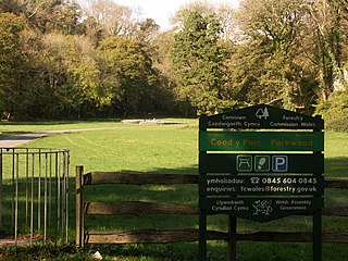
Parc le Breos was a great medieval deer park in the south of the Gower Peninsula, about eight miles (13 km) west of Swansea, Wales, and about 1+1⁄4 miles (2.0 km) north of the Bristol Channel. The park was an enclosed, oval area of 6.7 miles (10.8 km) in circumference, covering about 2,000 acres (810 ha) and measuring 2+1⁄2 miles (east–west) by just over 1+3⁄4 miles. Parc le Breos was established in the 1220s CE by John de Braose, Marcher Lord of Gower and husband to Margaret Ferch Llywelyn, Llywelyn Fawr's daughter. Other than for deer husbandry, the park received an income from agistment, pannage, and from sales of wild honey, ferns and dead wood. There is evidence of rabbit warrens in the park. Whether the warrens were free or domestic is unknown.

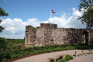
Pennard Castle is a ruined castle, near the modern village of Pennard on the Gower Peninsula, in south Wales. The castle was built in the early 12th century as a timber ringwork following the Norman invasion of Wales. The walls were rebuilt in stone by the Braose family at the turn of the 13th and 14th centuries, including a stone gatehouse. Soon afterwards, however, encroaching sand dunes caused the site to be abandoned and it fell into ruin. Restoration work was carried out during the course of the 20th century and the remains of the castle are now protected under UK law as a Grade II* listed building.
Pen y Clawdd Castle is a ditched mound with a double moat, roughly circular in shape, with a diameter of approximately 28m to 30m and about 2.4m high. The castle is in Llanvihangel Crucorney, about five miles to the north of Abergavenny, Monmouthshire, in south east Wales and lies between the Usk and Monnow rivers. The mound was designated a scheduled monument in 1950 and described as a defensive medieval motte.

Monmouth Priory, in Priory Street, Monmouth, Wales, is a building that incorporates the remains of the monastic buildings attached to St Mary's Priory Church. The priory was a Benedictine foundation of 1075, and parts of the mediaeval buildings remain. The buildings were substantially redeveloped in the nineteenth century for use as St Mary's National School, and now form a community centre. The complex is a Grade II* listed building as of 27 June 1952. It is one of 24 sites on the Monmouth Heritage Trail.

St Cadoc's Church, Raglan, Monmouthshire, south east Wales, is the parish church of the village of Raglan. The church is situated at a cross-roads in the centre of the village. Built originally by the Clare and Bluet families in the thirteenth and fourteenth centuries, it was rebuilt, and expanded by the Herbert's of Raglan Castle in the fifteenth century. In the nineteenth century, the church was subject to a major restoration by Thomas Henry Wyatt.

St John's Church was the parish church for Abergavenny, Monmouthshire until the Dissolution of the Monasteries when the priory church of St Mary's Priory became the parish church. The church then became a grammar school and is now part of a masonic lodge. The only parts of the church that still remain are the tower and part of the nave.

St Mellons Parish Church, also previously called St Melan's church, is a Church in Wales parish church in the Diocese of Monmouth in Old St Mellons, Cardiff, Wales. It was built around the 13th century and is a Grade I listed building.
Nant Ffrwdwyllt is a stream that runs through Cwm Dyffryn, within the county borough of Neath Port Talbot, Wales, from the village of Bryn, through the village of Goytre and the district of Taibach in Port Talbot, to the sea. The stream was originally a tributary of the River Afan but was diverted in the 18th century into the ironworks at what was to become Port Talbot to provide a source of water. It now flows into Port Talbot Docks. Several streets are or have been named after it, notably the present-day Ffrwdwyllt Street in Taibach, where the stream runs close to St Theodore's Church and the Talbot Memorial Park.

The Church of the Holy Cross, Kilgwrrwg, Monmouthshire, Wales, is an early medieval parish church that once supported a now abandoned village. A Grade II* listed building, the church remains an active parish church.
St Cadoc's or St Cadocs or St Catwg's may refer to:
The Register of Landscapes of Historic Interest in Wales is a non-statutory heritage register of 58 landscapes of outstanding or special historic interest published in two volumes. It was produced by a partnership between Cadw, the Countryside Council for Wales, and the International Council on Monuments and Sites working in collaboration with the Welsh Archaeological Trusts and several other organisations with the intention of aiding in the protection and conservation of the most important and significant historic landscape areas in Wales.
