
Chadderton is a town in the Metropolitan Borough of Oldham, Greater Manchester, England, on the River Irk and Rochdale Canal. It is located in the foothills of the Pennines, 1 mile (1.6 km) west of Oldham, 5 miles (8.0 km) south of Rochdale and 6 miles (9.7 km) north-east of Manchester.

Middleton is a town in the Metropolitan Borough of Rochdale, Greater Manchester, England, on the River Irk. It is 5 miles (8.0 km) southwest of Rochdale and 5 miles (8.0 km) northeast of Manchester. Middleton had a population of 42,972 at the 2011 Census. It lies on the northern edge of Manchester, with Blackley to the south and Moston to the south east.

St Ann's Church is a Church of England parish church in Manchester, England. Although named after St Anne, it also pays tribute to the patron of the church, Ann, Lady Bland. St Ann's Church is a Grade I listed building.

Hollinwood is an area and electoral ward of the Metropolitan Borough of Oldham, Greater Manchester, England. The population at the 2011 census was 10,920.

The Diocese of Salford is a Latin diocese of the Catholic Church centred on the City of Salford in Greater Manchester, England. The diocese was founded in 1852 as one of the first post-Reformation Catholic dioceses in Great Britain. Since 1911 it has formed part of the Province of Liverpool.

Hangleton is a suburb of Brighton and Hove, in the ceremonial county of East Sussex, England. The area was developed in the 1930s after it was incorporated into the Borough of Hove, but has ancient origins: its parish church was founded in the 11th century and retains 12th-century fabric; the medieval manor house is Hove's oldest secular building. The village became depopulated in the medieval era and the church fell into ruins, and the population in the isolated hilltop parish only reached 100 in the early 20th century; but rapid 20th-century development resulted in more than 6,000 people living in Hangleton in 1951 and over 9,000 in 1961. By 2013, the population exceeded 14,000.

Prestwich-cum-Oldham was an ancient ecclesiastical parish of the hundred of Salford, within the historic county boundaries of Lancashire, England. With the Parish Church of St Mary the Virgin, Prestwich as its centre, this parish encompassed a total of ten townships, and within them, several smaller chapelries.

Alkrington Garden Village is a suburban area of Middleton, in the Metropolitan Borough of Rochdale, Greater Manchester, England.
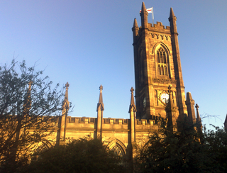
The Church of St. Mary with St. Peter, mostly known as Oldham Parish Church, is the Church of England parish church for Oldham in Greater Manchester, England. It forms part of the Diocese of Manchester, and is one of several Grade II* listed buildings in Greater Manchester.

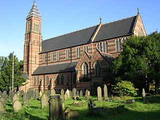
St Ann's Church, Stretford is a Grade II listed Roman Catholic church in Stretford, Greater Manchester, England. It was constructed between 1862 and 1863, on the east side of the A56 Chester Road. The parish functions under the jurisdiction of the Roman Catholic Diocese of Salford.

New Moston is a suburb of Manchester, England.

Mills Hill is an industrial and residential area that lies on the common border of Middleton and Chadderton in Greater Manchester, England. It lies 1.3 miles east of Middleton town centre and 1.4 miles to the west of central Chadderton. It is contiguous with Middleton Junction, Moorclose, Firwood Park and Chadderton Park. Mills Hill lies along the course of the Rochdale Canal and the River Irk.
The Church of St Cross, Clayton, Manchester, is a Victorian church by William Butterfield, built in 1863–66. It was designated a grade II* listed building in 1963.
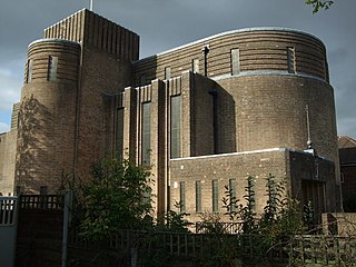
The Church of St Nicholas, Kingsway, Burnage, Manchester, is a Modernist church of 1930–2 by N. F. Cachemaille-Day, Lander and Welch. It was enlarged in 1964 with a bay on the west side, also by Cachemaille-Day. Pevsner describes the church as "a milestone in the history of church architecture in England". The church was designated a Grade II* listed building on 10 October 1980.
Freehold is an urban area of Werneth in Oldham, Greater Manchester, England. It occupies an area in the west of Werneth along the Oldham township boundary with Chadderton. It is contiguous on all sides with other urban areas, including parts of Werneth to the north and east, and Cowhill, Block Lane, and Butler Green/Washbrook in Chadderton.
Whitegate is an industrial and residential district of the town of Chadderton in the Metropolitan Borough of Oldham, Greater Manchester, England.

Butler Green is a residential area in the town of Chadderton in the Metropolitan Borough of Oldham, Greater Manchester. The area is also commonly known as Washbrook.
Block Lane is a locality in the town of Chadderton in the Metropolitan Borough of Oldham, Greater Manchester. It is located on Chadderton's eastern border with Oldham, contiguous with the Freehold area of that town, and with Cowhill and Butler Green.

Middleton Junction is an industrial and residential district lying on the common border of Middleton in the Metropolitan Borough of Rochdale and Chadderton in the Metropolitan Borough of Oldham, Greater Manchester.
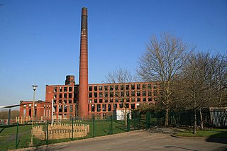
Chadderton is a town in the Metropolitan Borough of Oldham, Greater Manchester, England and it is unparished. It contains 19 listed buildings that are recorded in the National Heritage List for England. Of these, one is listed at Grade II*, the middle grade, and the others are at Grade II, the lowest grade. The area was rural until the coming of the Industrial Revolution, silk weaving arrived in the 18th century, and in the 19th and 20th centuries large cotton mills were built. The Rochdale Canal runs through the town, and two structures associated with it are listed, a bridge and a lock. The oldest listed buildings are farmhouses and a country house. The later buildings reflect the growing wealth of the town, and include cotton mills, churches, civic buildings, and a war memorial.


