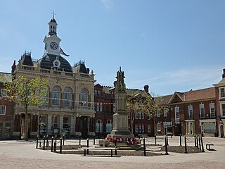
Retford, also known as East Retford, is a market town in the Bassetlaw District in Nottinghamshire, England. It lies on the River Idle and the Chesterfield Canal. Retford is located 26 miles (42 km) east of Sheffield, 23 miles (37 km) west of Lincoln and 31 miles (50 km) north-east of Nottingham. The population at the 2021 Census was 23,740. The town is bypassed by the A1 road.

North Leverton with Habblesthorpe is a village and civil parish in the Bassetlaw district, in the county of Nottinghamshire, England. It is about 5 miles or 8 km east of Retford. The population as at the 2011 Census was 1,047, and in the Census 2021 it had increased to 1,079.

Bassetlaw was a wapentake in the English county of Nottinghamshire. The wapentake covered an area in the north of the county, roughly equivalent to the modern Bassetlaw local government district. The wapentake was divided into the divisions of Hatfield, North Clay and South Clay.

South Leverton is a village and civil parish in Bassetlaw, north Nottinghamshire, England, four miles from Retford. According to the 2001 census it has a population of 478, increasing marginally to 480 at the 2011 census, and more substantially to 514 at the 2021 census.

Gamston is a village and civil parish four miles south of Retford in the English county of Nottinghamshire. The village lies on the A638 road between Retford and the Markham Moor junction with the A1 and the A57 roads. The population of the civil parish as at the 2011 Census was 246, which increased to 253 in 2021. The River Idle lies to the west of the village.

St Swithun's Church is a Grade II* listed Church of England parish in the Diocese of Southwell and Nottingham in East Retford, Nottinghamshire, England.

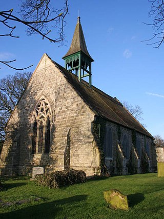
St Martin's Church is a Grade II listed parish church in the Church of England in Bole, Nottinghamshire.
All Saints' Church is a Grade II listed parish church in the Church of England in Eaton, Nottinghamshire.

St Giles' Church is a Grade I listed parish church in the Church of England.

Our Lady and St Peter's Church, Bothamsall is a Grade II listed parish church in the Church of England in Bothamsall. The church is part of the Lound Hall Estate, Bothamsall. The buildings repair costs are procured by the Lord of the manor.
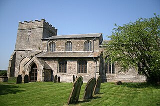
St Peter's Church, Gamston is a Grade I listed redundant parish church in the Church of England in Gamston, Bassetlaw.

All Saints’ Church, South Leverton is a Grade II* listed parish church in the Church of England in South Leverton, Nottinghamshire.

Lound Hall is a country house which sits in between the villages of Bothamsall and Bevercotes, in the county of Nottinghamshire, England. The current house was built in the Georgian style in the 1930s for Sir Harald Peake, a mining company director. There has been a manor house on the site since the 1700s. The hall was used as an orthopaedic hospital during World War II, and later became a training centre for the National Coal Board as well as a mining museum. It has now reverted to private ownership.

West Drayton is a village and civil parish in the Bassetlaw district in the county of Nottinghamshire, England. It lies 24 miles (39 km) north east of Nottingham and 4 miles (6.4 km) south of Retford.

Headon cum Upton is a civil parish in the Bassetlaw district, in the county of Nottinghamshire, England. The parish includes the villages of Headon, Upton and the hamlet of Nether Headon. The parish is adjacent to Askham, Gamston, East Drayton, Eaton, Grove, Rampton and Woodbeck, Stokeham and Treswell. In the 2021 census, the parish had a population of 192. The area is 3.5 miles south east of the nearest market town Retford, 26 miles north east of the county town Nottingham and 125 miles north of London. Headon cum Upton shares a parish council with Grove and Stokeham. There are 6 listed buildings in Headon cum Upton.
Headon is a village in Headon cum Upton civil parish, in the Bassetlaw district, of the county of Nottinghamshire, England. The village is adjacent to the villages of Upton, Nether Headon, East Drayton, Eaton, Gamston, Woodbeck and Stokeham. In 2011 the parish, together with Stokeham had a population of 253. The area is 3.5 miles south east of the nearest market town Retford, 26 miles north east of the county town Nottingham and 125 miles north of London. There are 2 listed buildings in Headon village.
Nether Headon is a hamlet in Headon cum Upton civil parish, within the Bassetlaw district, of the county of Nottinghamshire, England. It is 3.5 miles south east of the nearest market town Retford, 26 miles north east of the county town Nottingham and 125 miles north of London. The hamlet is adjacent to the villages of Upton, Headon, East Drayton, Eaton, Grove, Woodbeck and Stokeham. In 2011 the parish, together with Stokeham had a population of 253.
There are a number of listed buildings in Nottinghamshire. The term "listed building", in the United Kingdom, refers to a building or structure designated as being of special architectural, historical, or cultural significance. Details of all the listed buildings are contained in the National Heritage List for England. They are categorised in three grades: Grade I consists of buildings of outstanding architectural or historical interest, Grade II* includes significant buildings of more than local interest and Grade II consists of buildings of special architectural or historical interest. Buildings in England are listed by the Secretary of State for Culture, Media and Sport on recommendations provided by English Heritage, which also determines the grading.

