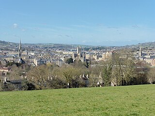
Bath and North East Somerset (B&NES) is a unitary authority district in Somerset, South West England. Bath and North East Somerset Council was created on 1 April 1996 following the abolition of the county of Avon. It is part of the ceremonial county of Somerset.

Barrow Gurney is a village and civil parish in Somerset, England, situated in the unitary authority of North Somerset on the B3130, midway between the A38 and A370 near the Long Ashton bypass and Bristol Airport, 5 miles (8.0 km) south west of Bristol city centre. The civil parish includes Barrow Common, and has a population of 349.

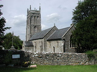
Farrington Gurney is a village and civil parish in Somerset, England located at the foot of the Mendip Hills on the junction of the A37 and A362. It has a population of 901.
Twerton is a suburb of the city of Bath, in the Bath and North East Somerset district, in the ceremonial county of Somerset, England, situated to the west of the city, and home to the city's football club, Bath City.

Newton St Loe is a small Somerset village and civil parish located close to the villages of Corston and Stanton Prior, between Bath and Bristol in England. The majority of the village is owned by the Duchy of Cornwall. The parish has a population of 681.
West Harptree is a small village and civil parish in the Chew Valley, Somerset within the unitary district of Bath and North East Somerset. The parish has a population of 439.

Englishcombe is a village and civil parish in Bath and North East Somerset just south-west of Bath, England. The parish, which also includes the hamlets of Inglesbatch and Nailwell, had a population of 318 at the 2011 census.

Charlcombe is a civil parish and small village just north of Bath in the Bath and North East Somerset unitary authority, Somerset, England. The parish had a population of 422 in 2011, and includes the villages of Woolley and Langridge and the hamlet of Lansdown.

Hemington is a village and civil parish 5.5 miles (8.9 km) north west of Frome, in the Mendip district of Somerset, England. It is located just off the A366 between Trowbridge and Radstock. The parish includes the villages of Hardington, Faulkland and Foxcote.

Swainswick is a small village and civil parish, 3 miles (4.8 km) northeast of Bath, on the A46 in the Bath and North East Somerset unitary authority, Somerset, England. The parish has a population of 265. The village name was also spelled Sweyneswik and Sweyneswick in the early 13th to 14th Century.

The Grade I listed buildings in Somerset, England, demonstrate the history and diversity of its architecture. The ceremonial county of Somerset consists of a non-metropolitan county, administered by Somerset County Council, which is divided into five districts, and two unitary authorities. The districts of Somerset are West Somerset, South Somerset, Taunton Deane, Mendip and Sedgemoor. The two administratively independent unitary authorities, which were established on 1 April 1996 following the breakup of the county of Avon, are North Somerset and Bath and North East Somerset. These unitary authorities include areas that were once part of Somerset before the creation of Avon in 1974.
The Anglican Church of SS Peter & Paul, Weston in Gordano, Somerset, England, has been designated as a Grade I listed building.

The Church of St Peter in Huish Champflower, Somerset, England dates from the 15th century, with the north aisle being built in 1534. It has been designated by English Heritage as a Grade I listed building.
The Church of St Gregory in Weare, Somerset, England dates from the 11th century, although most of the building is from the 15th, and has been designated as a grade I listed building.

The Church of St Mary in Mudford, Somerset, England, dates from the 14th century and has been designated as a Grade I listed building.

Montacute Priory was a Cluniac priory of the Benedictine order in Montacute, Somerset, England.
The Church of St Peter at Camerton Park in Camerton, Somerset, England was built in the 15th century and has been designated as a Grade I listed building.

The Church of St James is a redundant church in Cameley, Somerset, England, dating from the late 12th century. It is recorded in the National Heritage List for England as a designated Grade I listed building, and is in the care of the Churches Conservation Trust. It is dedicated to St. James of Compostela. The church was declared redundant on 1 January 1980, and was vested in the Trust on 18 March 1981.

Inglesbatch is a small hamlet within the civil parish of Englishcombe in the Bath and North East Somerset district of Somerset, England. Its nearest town is Bath, which lies approximately 3.7 miles (6.0 km) north-east from the hamlet. Inglesbatch Farm has an acreage of over 1,000 acres (400 ha).

Lyncombe is a district and electoral ward in Bath, Somerset, and a former parish in the Diocese of Bath and Wells. In the mid-19th century the parish was formed when the parish of Widcombe and Lyncombe was split in two, but it was abolished in the late 1960s. The village of Lyncombe existed since at least the Saxon period prior to becoming part of the City of Bath.


