
Norton is a town in Essex County, Vermont, United States. The population was 153 at the 2020 census. It is part of the Berlin, NH–VT Micropolitan Statistical Area. It is located on the Canada–US border, immediately south of Stanhope, Quebec.

Derby is a town in Orleans County, Vermont, United States. The population was 4,579 at the 2020 census, making it the most populous community in Orleans County. The town contains four unincorporated villages: Beebe Plain, Clyde Pond, Lake Salem and North Derby; and two incorporated villages: Derby Center and Derby Line.

Stanstead is a town in the Memphrémagog Regional County Municipality in the Estrie region of Quebec, located on the Canada–United States border across from Derby Line, Vermont.

Coaticook is a regional county municipality in the Estrie region of Quebec, Canada. The seat is Coaticook.

Beebe Plain is an unincorporated community in the town of Derby in Orleans County, Vermont, United States which extends into the Canadian municipality of Stanstead, Quebec. The village is divided by the Canada–United States border between Canada and the United States; the Canadian portion of Beebe Plain had the status of an incorporated municipality in its own right until 1995.

Compton—Stanstead is a federal electoral district in Quebec, Canada, that has been represented in the House of Commons of Canada since 1997.
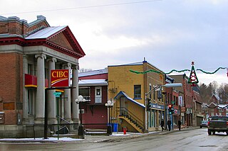
Coaticook is a town on the Coaticook River in southeastern Quebec, Canada. It is the seat of the Coaticook Regional County Municipality, and its southern border is also the Canada–United States border.

The Missisquoi River is a transboundary river of the east shore of Lake Champlain, approximately 80 miles (130 km) long, in northern Vermont in the United States and southern Quebec in Canada.
Route 147 (QC 147) is a 41.5-kilometre-long (25.8 mi) north–south highway that runs from the Vermont/United States border in the town of Stanhope. The route begins at the Norton–Stanhope Border Crossing in Stanhope. The route runs north through the Coaticook Regional County Municipality, crossing through Coaticook, Compton and Waterville before reaching a junction with QC 108 and QC 143 in Waterville, which marks the northern terminus of QC 147.
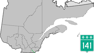
Route 141 is a north/south highway in Quebec on the south shore of the Saint Lawrence River. Its northern terminus is in Magog at the junction of Route 112 and Autoroute 10, and the southern terminus is in Saint-Herménégilde at the United States border in Canaan, Vermont.

Halls Stream or Rivière Hall is a 25.2-mile-long (40.6 km) tributary of the Connecticut River in eastern North America. For most of its length, it forms the Canada–United States border, with the province of Quebec (Canada) to its west and the state of New Hampshire to its east.

East Hereford is a municipality of about 260 people in southeastern Quebec, Canada, in Coaticook Regional County Municipality in the Estrie region.
Vermont Route 114 (VT 114) is a 53.094-mile-long (85.447 km) north–south state highway in northeastern Vermont in the United States. It runs northward from U.S. Route 5 (US 5) in Lyndon until nearing the Canada–United States border in the town of Norton; thereafter, the road continues east to the New Hampshire state line in Canaan. The vast majority of VT 114 is situated within Essex County; however, the route also passes through small, isolated portions of Caledonia and Orleans Counties.
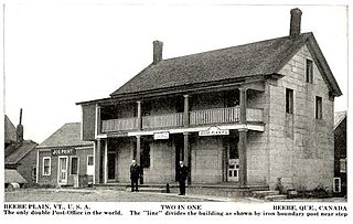
Beebe Plain is an unincorporated geographically-contiguous settlement, split politically between Canada and the United States. An unincorporated village partially in Stanstead and partially in Derby Line, it is divided by the Quebec-Vermont border. This settlement was begun by David and Calvin Beebe in 1798.

The North Troy–Highwater Border Crossing connects the town of Highwater, Quebec with North Troy, Vermont on the Canada–US border. It is located at the meeting point of Vermont Route 243 and Quebec Route 243. Both stations are open 24 hours per day for non-commercial traffic; the Canadian station is open to commercial traffic on weekdays during business hours. The former US station facilities, dating to the 1930s, are listed on the National Register of Historic Places.
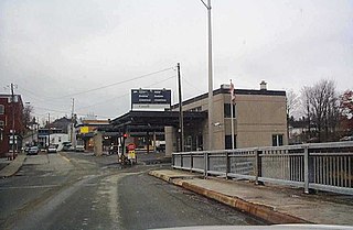
The Derby Line–Stanstead Border Crossing is a border crossing station on the Canada–United States border, connecting the towns of Stanstead, Quebec and Derby Line, Vermont. It connects Main Street in Derby Line with Quebec Route 143 in Stanstead. It is one of two local crossings between the two towns, which historically had many more. This was a major crossing point until the construction of Interstate 91 (I-91) and the Derby Line–Rock Island Border Crossing in 1965. The historic 1930s United States station facilities were listed on the National Register of Historic Places in 2014. Both stations are open 24 hours per day.

The Norton–Stanhope Border Crossing connects the towns of Stanhope, Quebec and Norton, Vermont on the Canada–US border. The crossing, at the meeting point of Quebec Route 147 and Vermont Route 147, is the only crossing between the two communities. The US border station, built in 1933, was listed on the National Register of Historic Places in 2014. Both stations are open 24 hours a day.
The Massawippi Valley Railway was a short line railway established 1870 between Lennoxville, Quebec, and the Vermont border. Part of the Quebec Central Railway from 1926, the line was abandoned in 1990 and removed in 1992. Most of the former railway's path is now bicycle trails.

The Coaticook River is a north-flowing river rising in Vermont, United States, and located primarily in the Estrie region of Quebec, Canada. The mouth of the river is located north of Waterville and south of Lennoxville, near the southern border of the city of Sherbrooke, at the Massawippi River. Via the Massawippi and the Saint-François River, it is part of the St. Lawrence River watershed.
The Pherrins River is a tributary of the Clyde River, flowing in Essex County and Orleans County in northern Vermont in United States.


