Stara Novalja

Last updated
Stara Novalja
Village
Stara Novalja.JPG
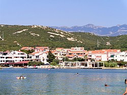
View of Stara Novalja
Croatia location map.svg
Red pog.svg
Stara Novalja
Coordinates: 44°35′48″N14°52′33″E / 44.59668°N 14.87592°E / 44.59668; 14.87592
CountryFlag of Croatia.svg  Croatia
County Flag of Lika-Senj County.svg Lika-Senj
Town Novalja
Area
[1]
  Total
11.4 km2 (4.4 sq mi)
Population
 (2021) [2]
  Total
281
  Density25/km2 (64/sq mi)
Time zone UTC+1 (CET)
  Summer (DST) UTC+2 (CEST)
Postal code
53 291

Stara Novalja is a village in the cove of the same name in the north-eastern part of the island of Pag, 5 kilometers north of Novalja in Croatia. The economy is based on farming, viniculture, fishing and tourism.

Contents

The cove of Stara Novalja is the submerged part of the "Pasko-Dinjiska" valley. The safest dock for larger ships is located south of the cove called "Drljanda", where the depth reaches 27–38 meters. Smaller ships and yachts drawing up to 3.5 meters are docked along the external part of the jointed pier in front of the village.

Stara Novalja is located on the M29 road. In its vicinity are remains of antique walls, a late antique necropolis, and ruins of the pre-Romanesque church of the Holy Cross.

Since the ferry harbor was relocated to Žigljen (except in some extraordinary weather conditions), Stara Novalja has become a quiet place that offers accommodation facilities in private homes, as well as lodging and boarding services. As such it is preferred by families. The major event is the feast day of Saints Peter and Paul on 29 June.

Beaches

The biggest beach in Stara Novalja is the sand beach, "Trincel". There are also many smaller beaches and jetties in front of the houses on the coastline.

Climate

The climate in the village is mild and Mediterranean. Springs are lush and green, summers are dry and warm, falls pleasant and winters mild with the cold northeast bora winds sometimes blowing. Daily summer temperatures can reach 30 degrees and nights are pleasantly fresher. Summer sea temperatures reach 25 degrees, while the bathing season starts in May.

Related Research Articles

<span class="mw-page-title-main">Marion, Massachusetts</span> Town in Massachusetts, United States

Marion is a town in Plymouth County, Massachusetts, United States. The population was 5,347 at the 2020 census.

<span class="mw-page-title-main">Rønde</span> Place in Mid Jutland, Denmark

Rønde is a town on the southern part of the peninsula, Djursland in Denmark, Northern Europe, 23 kilometers north-east of the north end of Denmark's second largest city, Aarhus. It is in part a commuter town to Aarhus, with a motorway entering Aarhus from the north. Rønde is located between Aarhus, and Aarhus Airport with a 12 kilometer drive from Rønde to the airport.

<span class="mw-page-title-main">Lake Superior Provincial Park</span> Provincial park in Ontario, Canada

Lake Superior Provincial Park is one of the largest provincial parks in Ontario, covering about 1,550 square kilometres (600 sq mi) along the northeastern shores of Lake Superior between Sault Ste. Marie and Wawa in Algoma District in Northeastern Ontario, Canada. Ontario Highway 17 now runs through the park. When the park was established by Ontario in 1944, there was no road access.

<span class="mw-page-title-main">Silba</span> Island of Croatia

Silba is an island in Croatia with an area of 15 km2, northern Dalmatia, south-east of Lošinj, between the islands of Premuda and Olib. It has a Mediterranean climate with 2570 hours a year of sunshine. Most summer days are hot, bright and clear with light westerly maestral wind cooling the island in the afternoons.

<span class="mw-page-title-main">Province of Belluno</span> Province of Italy

The province of Belluno is a province in the Veneto region of Italy. Its capital is the city of Belluno.

<span class="mw-page-title-main">Kalo Chorio, Lasithi</span> Community in Greece

Kalo Chorio is a village in the municipality of Agios Nikolaos, Lasithi, Crete, Greece. Kalo Chorio village has a population of around 900, nestled in the midst of a verdant hilly landscape, where olive groves, abundant and colorful mediterranean shrubs and plants reach all the way down to the sea. Over the past years, naturally with tourism, part of the village has grown nearer to the beach. Istro has many archaeological points of interest. The new village of Istro sits on the site of the ancient town of Istron, remains of which are still being uncovered to date. Because of this, the land closest to the sea has a conservation order and no new building may take place, which leaves the beaches uncrowded and unspoiled. The beaches of Istro Bay are regularly awarded a Blue flag for cleanliness. Kalo Chorio has a village atmosphere away from the sprawling concrete covered resorts usually found in Crete, making it popular amongst tourists who wish to enjoy Crete as it once was.

<span class="mw-page-title-main">Novalja</span> Town in Lika-Senj, Croatia

Novalja is a town in the north of the island of Pag in the Croatian part of Adriatic Sea. In recent times, Novalja has become famous because of the Zrće Beach.

<span class="mw-page-title-main">Honningsvåg</span> City/town within Nordkapp Municipality, Finnmark, Norway

Honningsvåg is the northernmost city/town in mainland Norway. It is located in Nordkapp Municipality in Finnmark county. Honningsvåg was declared a city in 1996, despite its small population. The 1.04-square-kilometre (260-acre) town has a population of 2,245 (2023), which gives the town a population density of 2,159 inhabitants per square kilometre (5,590/sq mi).

<span class="mw-page-title-main">Djursland</span> Peninsula in Denmark

Djursland is a 1,417 km2 hilly lowland peninsula in Denmark at the entrance to the Baltic Sea, between Denmark and Sweden in Northern Europe. Djursland protrudes into the Kattegat sea, as part of the larger peninsula of Jutland, which itself extends from the Central European continent. Djursland comprises the two municipalities of Norddjurs and Syddjurs.

<span class="mw-page-title-main">Rincón de la Victoria</span> Place in Andalusia, Spain

Rincón de la Victoria is a municipality in the province of Málaga in the autonomous community of Andalusia in southern Spain. It is the municipality with the highest well-being in the province of Malaga, according to the Synthetic Indicator of Economic Welfare developed by Andalusian Analysts. According to the same study, Rincón de la Victoria has the highest income per capita in Andalucia.

<span class="mw-page-title-main">Pag (island)</span> Island of Croatia

Pag is a Croatian island in the northern Adriatic Sea. It is the fifth-largest island of the Croatian coast and the one with the longest coastline.

<span class="mw-page-title-main">Iž</span> Croatian island

is an island in the Zadar Archipelago within the Croatian reaches of the Adriatic Sea. Its settlements are located exclusively on island's eastern part, facing Ugljan. The main settlement, Veli Iž, is situated in the bay on the north-eastern shore, while Mali Iž is situated on the south-eastern shore and consists of three hamlets — Muće, Makovac and Porovac — located on three hills, below which are two bays — the bay of Knež below Porovac and the bay of Komoševa below Makovac.

<span class="mw-page-title-main">Shelter Cove, California</span> Census-designated place in California, United States

Shelter Cove is a census-designated place in Humboldt County, California. It lies at an elevation of 138 feet. Shelter Cove is on California's Lost Coast where the King Range meets the Pacific Ocean. A nine-hole golf course surrounds the one-runway Shelter Cove Airport at the center of Shelter Cove's commercial district. Utilities are provided by the Humboldt County Resort Improvement District #1 and boating access to the sea is managed by the Humboldt Bay Harbor, Recreation & Conservation District. The population was 803 at the 2020 census.

<span class="mw-page-title-main">Sursura</span> Village in Rajasthan, India

Sursara, also known as Sursura is a village in Kishangarh tehsil in Ajmer district in the Indian state of Rajasthan, situated 8 km south of Rupangarh town on Parbatsar - Kishangarh road. This is the place where the Jat folk-deity Tejaji died from a snakebite when he back on the way after fighting with the enemies on 28 August 1103.

<span class="mw-page-title-main">Caravelí province</span> Province in Arequipa, Peru

Caravelí is one of eight provinces in the Arequipa Region of Peru, with its capital in the city of Caravelí. It borders the department of Ayacucho to the north; the provinces of La Unión, Condesuyos, and Camaná to the east; the Pacific Ocean to the south; and the department of Ica to the west.

<span class="mw-page-title-main">Playa Blanca</span> Town in Canary Islands, Spain

Playa Blanca is the southernmost town of the Spanish island of Lanzarote. It is the newest resort on the island, and is part of the municipality of Yaiza.

<span class="mw-page-title-main">Arch Cape, Oregon</span> Unincorporated community in the state of Oregon, United States

Arch Cape is an unincorporated community in Clatsop County, Oregon, United States. Named for the natural arch in the coastal rocks and the headland (cape) that extends into the Pacific Ocean, it is located along the Pacific coast, approximately four miles south of Cannon Beach, between Hug Point State Recreation Site to the north and Oswald West State Park to the south.

<span class="mw-page-title-main">Koromačno</span> Village in Istria County, Croatia

Koromačno is a small hamlet adjacent to the cement factory for which it was built in the early 1900 for the workers. It is also a small port to accept small cargo ships to carry the cement to other placed to be processed. It is located in the southernmost tip of the Labinština peninsula in Istria County in Croatia. It is nestled between Croatian: Crna Punta and Croatian: Ubac on the Gulf of Quarnero in the Adriatic Sea. It is one of the newest hamlet not even 100 years old. It is located about 15 km from Croatian: Labin / Italian: Albona, 1 km from Croatian: Brovinje, 3 km from Croatian: Skitača.

<span class="mw-page-title-main">Dramalj</span> Village in Croatia

Dramalj is a small fishing village in Croatia. It is part of the town of Crikvenica, extending from the neighborhood Crni mol to the tourist complex Kačjak. A tourism boom in the nearby Crikvenica area and the rest of the Croatian Littoral in the 19th century drove the development of Dramalj.

<span class="mw-page-title-main">Tofino</span> District municipality in British Columbia, Canada

Tofino is a town of approximately 2,516 residents on the west coast of Vancouver Island in the Canadian province of British Columbia. The District of Tofino is located at the western terminus of Highway 4 on the tip of the Esowista Peninsula at the southern edge of Clayoquot Sound. It is situated in the traditional territory of the Tla-o-qui-aht First Nations.

References

  1. Register of spatial units of the State Geodetic Administration of the Republic of Croatia. Wikidata   Q119585703.
  2. "Population by Age and Sex, by Settlements" (xlsx). Census of Population, Households and Dwellings in 2021. Zagreb: Croatian Bureau of Statistics. 2022.