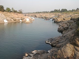
Jharkhand is a state in eastern India. The state shares its border with the states of West Bengal to the east, Chhattisgarh to the west, Uttar Pradesh to the northwest, Bihar to the north and Odisha to the south. It is the 15th largest state by area, and the 14th largest by population. Hindi is the official language of the state. The city of Ranchi is its capital and Dumka its sub-capital. The state is known for its waterfalls, hills and holy places; Baidyanath Dham, Parasnath, Dewri and Rajrappa are major religious sites. Jharkhand is primarily rural, with about 24% of its population living in cities.
Bujurg Jamira is a town in the Patratu CD block in the Ramgarh subdivision of the Ramgarh district in the Indian state of Jharkhand.
Balkundra is a census town in the Patratu CD block in the Ramgarh subdivision of the Ramgarh district in the state of Jharkhand, India.
Barkakana is a census town in the Patratu CD block in the Ramgarh subdivision of the Ramgarh district in the state of Jharkhand, India.
Patratu is a census town in the Patratu in the Ramgarh subdivision of the Ramgarh district in the Indian state of Jharkhand.

Ramgarh Cantonment, usually referred to as Ramgarh Cantt or just Ramgarh is a cantonment town, belonging to the Ramgarh district of the Indian state of Jharkhand. Historically, a subdivision of the larger Hazaribag district, Ramgarh was finally elevated to a district status on 12 September 2007 largely to ease administrative hardships.
Mohania is a city and corresponding community development block in Kaimur district of Bihar, India. It serves as headquarters for the Mohania sub-division in Kaimur district. It is 17 km (11 mi) by road north of the city of Bhabua, at the intersection of National Highway 19, NH-219, and NH-319. The bank of the Durgavati River is just to the south of Mohania. The total block population was 218,479, in 32,198 households.

Ramgarh district is one of the 24 districts in the Indian state of Jharkhand. It was also a military district during the British Regime, referred to then as Ramgarh district. It is the part of State Capital Region (SCR).
Bhurkunda is a town in the Patratu CD block in the Ramgarh subdivision of the Ramgarh district in Jharkhand, India.
Patratu (community development block) is an administrative division in the Ramgarh subdivision of the Ramgarh district in the Indian state of Jharkhand.
Ramgarh (community development block) is an administrative division in the Ramgarh subdivision of the Ramgarh district in the Indian state of Jharkhand.
Dulmi (community development block) is an administrative division in the Ramgarh subdivision of the Ramgarh district in the Indian state of Jharkhand.
Chitarpur (community development block) is an administrative division in the Ramgarh subdivision of the Ramgarh district in the Indian state of Jharkhand.
Gola (community development block) is an administrative division in the Ramgarh subdivision of the Ramgarh district in the Indian state of Jharkhand.
Gola is a village in the Gola CD block in the Ramgarh subdivision of the Ramgarh district in the Indian state of Jharkhand.

Hesla is a census town in the Patratu CD block in the Ramgarh subdivision of the Ramgarh district in the Indian state of Jharkhand.
Lapanga is a census town in the Patratu CD block in the Ramgarh subdivision of the Ramgarh district in the Indian state of Jharkhand.
Seota is a census town in the Mandu CD block in the Ramgarh subdivision of the Ramgarh district in the Indian state of Jharkhand.
Ramgarh subdivision is an administrative subdivision of Ramgarh district in the North Chotanagpur division in the Indian state of Jharkhand.
State Highway 6 is a state highway in Jharkhand, India.


