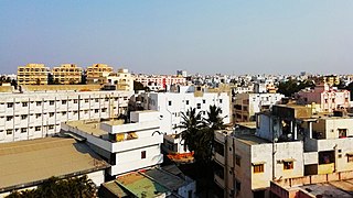
Ongole is a city in Prakasam district of the Indian state of Andhra Pradesh. It is the headquarters of Prakasam district. It is famous for Ongole cattle, an indigenous breed of oxen.

Anantapur, officially Anantapuramu, is a city in Anantapur district of the Indian state of Andhra Pradesh. It is the mandal headquarters of Anantapuru mandal and also the divisional headquarters of Anantapur revenue division. The city is located on National Highway. It was also the headquarters of the Datta Mandalam in 1799. It was also a position of strategic importance for the British Indian Army during the Second World War. The GDP of Anantapur City is $ 1.728 Billion.

Kurnool is a city in the state of Andhra Pradesh, India. It formerly served as the capital of Andhra State (1953–1956). The city is often referred to as "The Gateway of Rayalaseema". Kurnool is also famous for Diamond hunting as diamonds can be found in the barren land of Kurnool after the top layers of soil are washed away by the monsoon rains. It also serves as the district headquarters of its Kurnool district. As of 2011 census, it is the fifth most populous city in the state with a population of 484,327. It is located on the banks of the Tungabhadra river. Although the area has been inhabited for thousands of years, modern Kurnool was founded in the 16th century CE with the construction of the Konda Reddy Fort.

Kavali is a town in Nellore district of Andhra Pradesh of India. It also serves as headquarters of Kavali mandal and Kavali revenue division.It is one of the few cities from Andhra Pradesh which were selected for Atal Mission for Rejuvenation and Urban Transformation (AMRUT) Scheme.

Vizianagaram district is one of the six districts in the Uttarandhra region of the Indian state of Andhra Pradesh with its headquarters located at Vizianagaram. The district was once the part of ancient Kalinga.Saripilli Dibbilingeswara temple, Jayathi Mallikarjuna Temple are the finest examples of ancient Eastern Ganga Dynasty built monuments in the district. The district is bounded on the east by the district of Srikakulam, north by Parvathipuram Manyam south by Visakhapatnam, Anakapalli, southeast by the Bay of Bengal, and west by Alluri Sitharama Raju district. It was formed on 1 June 1979, with some parts carved from the neighbouring districts of Srikakulam and Visakhapatnam. The district is named after the princely state of Vizianagaram. In 2011, it was the least populous district in Andhra Pradesh.

Prakasamdistrict is one of the twelve districts in the coastal Andhra region of the Indian state of Andhra Pradesh. It was formed in 1970 and reorganised on 4 April 2022. The headquarters of the district is Ongole. It is located on the western shore of Bay of Bengal and is bounded by Bapatla district and Palnadu districts in the north, Nandyal district in the west, Kadapa and Nellore districts in the south. A part of north west region also borders with Nagarkurnool district of Telangana. It is the largest district in the state with an area of 14,322 km2 (5,530 sq mi) and had a population of 22,88,026 as per 2011 Census of India.
National Highway 67 is a major National Highway in India. It starts at Ramnagar on NH 748, Belagavi - Panjim Road of Karnataka and ends at Krishnapatnam Port road in Andhra Pradesh.

Vejendla is a village in Guntur district of the Indian state of Andhra Pradesh. It is supposed to be the headquarters of Chebrolu mandal in Tenali revenue division. It is located in Chebrolu mandal of Tenali revenue division.
National Highway 26, , is a National Highway in India, that connects Bargarh in Odisha and passes through Odisha to connect with Rajapulova in Vizianagaram district of Andhra Pradesh. It connects National Highway 5 and National Highway 6 and transverses the Eastern Ghats.
National Highway 716 is a National Highway in India. It starts from its junction with NH 16 near Chennai in Tamil Nadu and terminates at its junction with NH 67 near Muddanur in Andhra Pradesh.
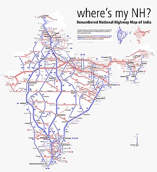
Andhra Pradesh is well connected with various destinations in India, as well as other countries. It has road, rail, airways. With a long coast of Bay of Bengal and many sea ports, it flourishes in sea trade as well. The state has one of the largest railway junctions at Vijayawada and Visakhapatnam Port being one of the largest cargo handling seaport.
National Highway 216 is a National Highway in the Indian state of Andhra Pradesh. The former highways of NH 214 and 214A were merged and renumbered as NH 216. It starts from NH 16 junction at Kattipudi and passes through Kakinada, Amalapuram, Digamarru (Palakollu), Narasapuram, Machilipatnam, Repalle, Cherukupalle, Bapatla, Chirala before it junctions NH 16 again at Ongole. Visakhapatnam–Kakinada Petro Chemical Corridor, is a proposed project along the highway.
State Highway 30 (Andhra Pradesh) is a state highway in Anantapur district of the Indian state of Andhra Pradesh
State Highway 31 is a state highway in the Indian state of Andhra Pradesh which connects Renigunta and Muddanur in the state. It is the longest known state highway in Kadapa and Chittoor districts collectively.
National Highway 326 is a National Highway in the Indian states of Andhra Pradesh and Odisha. It was formed as a new highway by up-gradation of former state highways of the states. It starts at Asika of Odisha and ends at Chinturu road of Andhra Pradesh.
National Highway 544D, commonly called NH 544D, and sometimes Anantapur-Guntur National highway 544D, is a national highway in India. It is a spur road of National Highway 44. NH-544D traverses the state of Andhra Pradesh in India.

National Highway 340C, commonly called NH 340C is a national highway in India. It is a spur road of National Highway 40. NH-340C traverses the state of Andhra Pradesh in India.
National Highway 365BB is a national highway in India. It is a secondary route of National Highway 65. NH-365BB traverses the states of Telangana and Andhra Pradesh in India. It starts at Suryapet and ends at Kovvur(Rajamahendravaram).Major cities on this route are Suryapet, Khammam and Rajamahendravaram.


