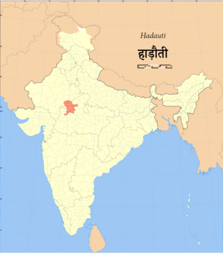
Hadauti or Harauti (Hadoti) is an Indo-Aryan language of Rajasthani languages group spoken by approximately four million people in the Hadoti region of southeastern Rajasthan, India. Its speakers are concentrated in the districts of Kota, Baran, Bundi and Jhalawar in Rajasthan, as well as in neighbouring areas of Madhya Pradesh.
Hadoti is a region of Rajasthan state in western India, which was once called the Bundi Kingdom. The biggest cities are Jhalawar and Kota. It includes the districts of Bundi, Baran, Jhalawar and Kota and is bounded on the west by the Mewar, on the northwest by Ajmer regions of Rajasthan, and on the south by the Malwa, on the east by the Gird regions of Madhya Pradesh state.

The Kali Sindh (Krashna Sindhu), is a river in Madhya Pradesh and Rajasthan in northern India. It is a tributary of the Chambal River in the Ganges Basin. The main tributaries of the Kali Sindh are the Parwan, Niwaj and Ahu rivers. The Kali Sindh River drains a major portion of the Malwa region, and is the biggest river flowing in the Malwa region of Madhya Pradesh.

Jhalawar ( ) is a city, municipal council and headquarter in Jhalawar district of the Indian state of Rajasthan. It is located in the southeastern part of the state. It was the capital of the former princely state of Jhalawar, and is the administrative Jhalawar district. Its district headquarters is Jhalawar. This district is the 22nd largest district of Rajasthan. This district is known by the nicknames of Cherrapunji of Rajasthan, Nagpur of Rajasthan, Brijnagar of Rajasthan etc. Cherrapunji of rajasthan because the highest rainfall in the whole of Rajasthan occurs in manoharthana town in this district. Gagron fort at the confluence of Kalisindh and Ahu river at some distance from Jhalawar It is situated which is one of the Jaldurg of Rajasthan and it is such a fort which is a standing fort without foundation. This fort was included in the UNESCO World Heritage List in 2013.

Jhalawar district is one of the 33 districts of Rajasthan state in western India. The historical city of Jhalawar is the administrative headquarters of the Jhalawar district. The district is bounded on the northwest by Kota district, on the northeast by Baran district, on the east by Guna district of Madhya Pradesh state, on the south by Rajgarh district and Agar Malwa district of Madhya Pradesh state and on the west by Ratlam district and Mandsaur district of Madhya Pradesh state. The district occupies an area of 6219 km². The district is part of Kota division. To know more about Jhalawar City
Aklera is a town and an Indian municipality in Jhalawar district in the state of Rajasthan. It is in the south-eastern region of Rajasthan at the edge of the Malwa plateau and has a rocky, scrub-covered terrain.
Bhawani Mandi is a town and a municipality in Jhalawar district in the state of Rajasthan, India.
Ramganj Mandi is a city and a municipality in Kota district in the Indian state of Rajasthan. It is also known by the names "Stone city" and "Coriander city". It has the largest grain market of coriander with around 6500 tons of coriander seeds arriving on a single day during season. Spices Giant MDH buys its coriander seeds from Ramganj Mandi. A new spice park is being constructed on Nimana road, the link road between SH 9B and NH 12. Annually billions of square feet of limestone is exported throughout the country, mainly in Punjab, Haryana, Chandigarh, Gujarat, Maharashtra and Madhya Pradesh. Around 1000 stone processing units are set up in the industrial area. More than 80 mines are present in the area.
Bhawani Mandi railway station is a railway station serving Bhawani Mandi town, a border town in Jhalawar district of Rajasthan State of India. It is under Kota railway division of West Central Railway Zone of Indian Railways.
Madhya Pradesh State Highway 27 runs in Jhalawar in Rajasthan, Ujjain in Madhya Pradesh and Malkapur in Maharashtra it cover 386.60 km.

The Madhya Pradesh Road Development Corporation Limited (MPRDC) is an Undertaking of Government of the state of Madhya Pradesh, India, responsible for management of a network of over 22,000 km of National Highways, State Highways and Major District Roads in Madhya Pradesh. Madhya Pradesh State has a good road network. There are 20 National Highways with total length of 4,000 km and many State Highways with total length of 9,000 km. Shri. Shivraj Singh Chouhan, Chief Minister of Madhya Pradesh is the Chairman, while Shri Asheesh Singh, IAS is Managing Director of MPRDC.

Parban River originates in Madhya Pradesh and flows through Rajasthan. It is a tributary of the Kali Sindh. Parban/Parvan originates in Sehore district of Madhya Pradesh and flows through Sehore, Shajapur and Rajgarh districts in Madhya Pradesh. It also flows through Jhalawar, Kota, Baran districts of Rajasthan. Before it joins the Kali Sindh it cuts a 10 km long valley of significant depth right across Ratibar Dungar near Akawad Kalan in Jhalawar district. It meets Kali Sindh in Baran district of Rajasthan. Shergarh wildlife Sanctuary situated at the bank of Parban river in Baran district.
Madhya Pradesh State Highway 31 is a State Highway running from Nayagaon till Khargone.
Madhya Pradesh State Highway 39 is a State Highway running from Sendhwa town in Barwani district lying near NH-52 till Thandla town.
Madhya Pradesh State Highway 39A is a branch line of MP SH-39) running from Thandla town till Kushalgarh at the Madhya Pradesh-Rajasthan border.
Madhya Pradesh State Highway 2 is a State Highway running from Bhind in Madhya Pradesh till Karauli in Rajasthan via Ater, Morena, Joura and Sabalgarh.
Madhya Pradesh State Highway 6 is a State Highway running from Shivpuri till Goras town near Madhya Pradesh - Rajasthan border.
Madhya Pradesh State Highway 19 is a 651.7 kilometres (404.9 mi) long State Highway running from Porsa town near MP-UP border via Mehgaon, Datia, Narwar, Sultanpur, Bareli, Piparia, Matkuli, Tamia, Parasia and terminates at Chhindwara city. It is an important highway which connects important towns of Northern Madhya Pradesh and Southern Madhya Pradesh.
Madhya Pradesh State Highway 10 is a State Highway running from Guna city in Guna district via Sironj, Berasia and terminates at Bhopal, the capital town of Madhya Pradesh. It is alternatively known as the Hirapur Bypass, the Aron Bypass, and Berasia Road.
