Station Road, Cambridge

Last updated

The roundabout at the end of Station Road, with the railway station behind. Cambridge station building3.JPG
The roundabout at the end of Station Road, with the railway station behind.
Sculpture of Ceres on Foster Mill in Station Road. StatueFostersMillCambridge.jpg
Sculpture of Ceres on Foster Mill in Station Road.

Station Road is a road in southeast Cambridge, England. [1] [2] [3] It leads from a junction with traffic lights on Hills Road (A1307) to the Cambridge railway station. [4] At the western end of Station Road on the opposite side of Hills Road is the Cambridge University Botanic Garden.

Contents

Buildings

The station and a war memorial at the two ends of the road are Grade II listed. [3] The view along Station Road has a leafy appearance. There are a number of Victorian houses on the north side of the road. [5] These have lost their gardens and been converted for commercial use.

The south side of the road is main large modern buildings. For example, Jupiter House was built in 1974. [6] It was reclad in the 1980s. Daedalus House is also located on the south side.

In 2016 a major redevelopment of the eastern end of Station Road was undertaken by the CB1 estate. [7] Five major buildings were constructed providing approximately 500,000 SQ FT of office space. 30 Station Road was the last of these buildings to be constructed, slated for completion in 2020.

Foster's Mill

Foster's Mill (also known as Foster Mills, Foster Mill and Spiller's Mill), off Station Road, was built of painted gault brick in 1898, designed by the architects Gelder and Kitchen of Hull. [3] [8] It is one of the largest buildings in Cambridge, as well as being one of the few examples of large-scale industry in the city. The Foster family owned three mills in the city but the University of Cambridge prevented them from constructing railway lines to them, so they built this mill immediately next to the railway station.

In 1917, Foster's Mill was sold to Pauls Agriculture and in 1947 it was sold to Spillers. Additions were made to the building in 1953. In 2000, it was owned by Rank Hovis. In 2001, it was announced that Rank Hovis would vacate the site eventually to enable redevelopment of the site.

The Foster family also founded Fosters' Bank for use by their mill workers, with a site in Sidney Street in central Cambridge. The building (now a Lloyds Bank branch) was designed by the Victorian architect Alfred Waterhouse and built 1890–93. [9] The name still exists over the doorway. The interior of the bank is vaulted and highly decorated with tiles,

On 27 March 2010, during extensive demolition work on the mill, a major fire "accidentally" broke out which damaged the mill buildings causing their partial collapse. [10] The remaining section of the building will become 19 residential apartments as part of the CB1 development. [11]

Cambridge Station and Spiller's Mill - geograph.org.uk - 1779370.jpg
Spiller's Mill after the fire - geograph.org.uk - 1777810.jpg
Foster's Mill before and after the 2010 fire.

Demeter House

Demeter House Demeter House, Cambridge, England - IMG 0735.JPG
Demeter House

Demeter House, on Station Road, was built in the 1960s. It is one of three similar office blocks, the others being 20 Station Road (formerly Leda House), and Jupiter House. The building is currently one of the principal offices for Mott MacDonald.

Railway station

The railway station opened in 1845 when the Eastern Counties Railway opened to Cambridge. The station building has a long classical façade and porte-cochère, which was infilled during the 20th century. It has been attributed to both Sancton Wood and Francis Thompson [12] and is listed Grade II.

The single very long platform is typical of its period but now unusual in that, apart from a brief period in the mid-19th century, it was never supplemented by another through platform. There were major platform lengthenings and remodellings of the main building in 1863 and 1908. The station layout was altered in 1896 through changes to the Newmarket line approaches.

Cambridge rail station.jpg
View of the railway station at the end of Station Road.

Related Research Articles

<span class="mw-page-title-main">King's Cross, London</span> Area of central London in England

King's Cross is a district on either side of Euston Road, in north London, England, 1.5 miles (2.4 km) north of Charing Cross. It is bordered by Barnsbury to the north, Clerkenwell and Islington to the east, Holborn to the south and Somers Town to the west. It is served by two major rail termini, St Pancras and King's Cross. King's Cross station is the terminus of one of the major rail routes between London and the North.

<span class="mw-page-title-main">Camden Town tube station</span> London Underground station

Camden Town is a London Underground station in Camden Town. It is a major junction for the Northern line, as it is where the Edgware and High Barnet branches merge from the north, and is also where they split to the south into the Bank and Charing Cross branches for the journey through Central London. It is particularly busy with visitors to the Camden markets at weekends, and, until 2019, was exit-only on Sundays to prevent overcrowding.

<span class="mw-page-title-main">Blackfriars station</span> London Underground and railway station

Blackfriars, also known as London Blackfriars, is a central London railway station and connected London Underground station in the City of London. It provides Thameslink services: local, and regional and limited Southeastern commuter services to South East London and Kent. Its platforms span the River Thames, the only one in London to do so, along the length of Blackfriars Railway Bridge, a short distance downstream from Blackfriars Bridge. There are two station entrances either side of the Thames, along with a connection to the London Underground District and Circle lines.

<span class="mw-page-title-main">King William Street tube station</span> Former railway station in England

King William Street was the original but short-lived northern terminus of the City and South London Railway (C&SLR), the first successful deep-level underground railway in London and one of the component parts of the London Underground's Northern line. It was located in the City of London, on King William Street, just south of the present Monument station. When King William Street was in operation the next station to the south was Borough and the southern terminus of the line was Stockwell.

<span class="mw-page-title-main">Royal Victoria Dock</span> Historic site in London

The Royal Victoria Dock is the largest of three docks in the Royal Docks of east London, now part of the redeveloped Docklands.

<span class="mw-page-title-main">Salford Quays</span> Area of Salford, Greater Manchester, England

Salford Quays is an area of Salford, Greater Manchester, England, near the end of the Manchester Ship Canal. Previously the site of Manchester Docks, it faces Trafford across the canal.

<span class="mw-page-title-main">Atlantic Wharf</span> Area of south Cardiff, Wales

Atlantic Wharf is a southern area of the city of Cardiff, Wales. It is primarily an area of new houses and apartments located on the west side of the disused Bute East Dock and to the east of Lloyd George Avenue. It also includes a number of refurbished dock warehouses, modern hotels, the Red Dragon Centre and Cardiff Council's County Hall. Atlantic Wharf lies in the Butetown electoral division of Cardiff and the Cardiff South and Penarth constituency for the UK Parliament and the Senedd.

<span class="mw-page-title-main">Golden Mile (Brentford)</span>

The Golden Mile is a stretch of the Great West Road north of Brentford running west from the western boundary of Chiswick in London, United Kingdom.

<span class="mw-page-title-main">Cardiff city centre</span> Central Business District in Wales

Cardiff city centre is the city centre and central business district of Cardiff, Wales. The area is tightly bound by the River Taff to the west, the Civic Centre to the north and railway lines and two railway stations – Central and Queen Street – to the south and east respectively. Cardiff became a city in 1905.

<span class="mw-page-title-main">Cambridge railway station</span> Railway station in Cambridge, England

Cambridge railway station is the principal station serving the city of Cambridge in the east of England. It stands at the end of Station Road, 1 mile (1.6 km) south-east of the city centre. It is the northern terminus of the West Anglia Main Line, 55 miles 52 chains (89.6 km) down the line from London Liverpool Street, the southern terminus.

<span class="mw-page-title-main">Sendai Station (Miyagi)</span> Major railway and metro station in Sendai, Japan

Sendai Station is a major junction railway station in Aoba-ku, Sendai, Miyagi, Japan. It is a stop for all Akita, Hokkaido, and Tohoku Shinkansen trains, the eastern terminus for the Senzan Line, and major stop on both the Tohoku Main Line and Senseki Line. It is located on the border between Miyagino and Aoba Wards in Sendai, Miyagi Prefecture.

<span class="mw-page-title-main">Rhodes railway station</span> Railway station in Sydney, New South Wales, Australia

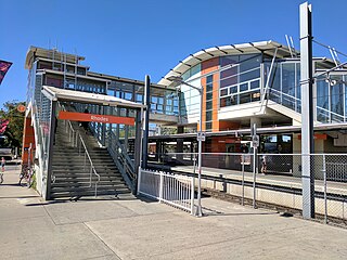
Rhodes railway station is a heritage-listed railway station located on the Main Northern line, serving the Sydney suburbs of Rhodes and Liberty Grove both in City of Canada Bay, Sydney, New South Wales, Australia. It is served by Sydney Trains T9 Northern Line services.
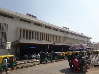
<span class="mw-page-title-main">South Wigston</span> Human settlement in England

South Wigston is a large village to the south of Leicester, England. It is outside the city boundary, forming part of the Oadby and Wigston district of Leicestershire. The population of the ward rose slightly from 7,471 at the 2001 census to 7,490 at the 2011 census.

<span class="mw-page-title-main">Peterborough East railway station</span> Former railway station in Cambridgeshire, England

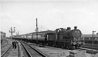
Peterborough East was a railway station in Peterborough, England. It was opened on 2 June 1845 and closed to passenger traffic on 6 June 1966. Located on East Station Road just off Town Bridge, only the engine sheds and one platform remain. The station had services running west to Northampton and Rugby, as well as to the east to March, Wisbech, and Norwich.

<span class="mw-page-title-main">Blunham railway station</span> Former railway station in Bedfordshire, England

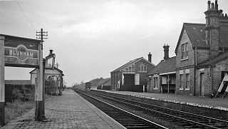
Blunham was a railway station on the Varsity Line which served the small village of the same name in Bedfordshire. Opened in 1862, the station was located in a rural area and saw little passenger traffic; it closed together with the line in 1968.

<span class="mw-page-title-main">Sidney Street, Cambridge</span> Major street in central Cambridge, England

Sidney Street is a major street in central Cambridge, England. It runs between Bridge Street at the junction with Jesus Lane to the northwest and St Andrew's Street at the junction with Hobson Street to the southeast.

<span class="mw-page-title-main">Spillers</span>

Spillers Ltd was a British company that owned flour milling operations, operated bakeries and also sold pet food and equine feeds.

The 1950s and 1960s saw the construction of numerous brutalist apartment blocks in Sheffield, England. The Sheffield City Council had been clearing inner-city residential slums since the early 1900s. Prior to the 1950s these slums were replaced with low-rise council housing, mostly constructed in new estates on the edge of the city. By the mid-1950s the establishment of a green belt had led to a shortage of available land on the edges of the city, whilst the government increased subsidies for the construction of high-rise apartment towers on former slum land, so the council began to construct high-rise inner city estates, adopting modernist designs and industrialised construction techniques, culminating in the construction of the award-winning Gleadless Valley and Park Hill estates.

<span class="mw-page-title-main">Ringway Centre</span> Building in Birmingham, England

Ringway Centre is a Grade B locally listed building located on Smallbrook Queensway in the city centre of Birmingham, England. The six-storey, 230 metres (750 ft) long building was designed by architect James Roberts as part of the Inner Ring Road scheme in the 1950s and is notable for its gentle sweeping curved frontal elevation.

<span class="mw-page-title-main">Cardiff Bus Interchange</span> Bus station in Cardiff, Wales

Cardiff Bus Interchange is a new bus and transport interchange, as well as offices and apartments, in the centre of Cardiff, the capital city of Wales. It has been under construction since 2020 and is due for completion in Spring 2024. Once completed it will be run by the Welsh Government's transport arm, Transport for Wales. The bus station at the southern end of the complex is eight storeys high with 14-bays for buses on the ground floor, whilst the Interchange Tower at the northern end has 318 for-rent apartments, two floors of office space, and a retail unit on the ground floor.

References

  1. Station Road, Cambridge Online.
  2. TL4557: Station Road, Cambridge, Geograph.
  3. 1 2 3 Station Area Conservation Appraisal , Quality Built Environments (QuBE), prepared for Cambridge City Council. June 2004.
  4. Station Road: railway station, Cambridge 2000.
  5. Station Road: Studio School of English, 6, Cambridge 2000.
  6. Station Road: Jupiter House, Cambridge 2000.
  7. "Home". cb1estate.com.
  8. .Station Road: Foster Mill, Cambridge 2000.
  9. Sidney Street: Lloyds TSB Bank, Cambridge 2000.
  10. BBC News, 27 March 2010
  11. Ceres CB1 Cambridge - Prestigious Modern Apartments for sale Cambridge
  12. Biddle, Gordon & Nock, O. S. (1983). The Railway Heritage of Britain. Michael Joseph.

Commons-logo.svg Media related to Station Road, Cambridge at Wikimedia Commons at the end of Station Road

52°11′41″N0°08′00″E / 52.1948°N 0.1334°E / 52.1948; 0.1334