
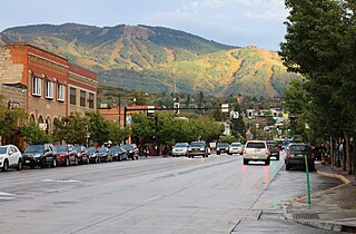
Steamboat Springs, often shortened to Steamboat, is a Home Rule Municipality that is the county seat and the most populous city of Routt County, Colorado, United States. As of the 2010 census, the city population was 12,088.
Intrawest Resorts Holdings, Inc was a developer and operator of destination resorts and a luxury adventure travel company. The company was founded in 1976 as a privately funded real estate development company. In 2006, Intrawest was purchased by Fortress Investment Group, a private equity investment company, which resulted in the company being delisted from the Toronto Stock Exchange and New York Stock Exchange. Fortress was under financial pressure related to the Intrawest debt, but a new loan with a single lender was completed in April 2010 and all prior lenders were repaid in full.
The Park Range, elevation approximately 12,000 feet (3,700 m), is a mountain range in the Rocky Mountains of northwestern Colorado in the United States. The range forms a relatively isolated part of the Continental Divide, extending north-to-south for approximately 40 miles (64 km) along the boundary between Jackson (east) and Routt counties. It separates North Park in the upper basin of the North Platte River on the east from the Elk River basin in the watershed of the Yampa River the west. It rises steeply out of the Yampa River basin, forming a climatic barrier that receives much snowfall in winter. The northern end of the range lies in Wyoming and is known as the Sierra Madre Range.
The Great Seal of the State of Florida is used to represent the government of the state of Florida, and for various official purposes, such as to seal official documents and legislation. It is commonly used on state government buildings, vehicles and other effects of the state government. It also appears on the state flag of Florida. The University of Florida was bestowed the honor of using the seal as its university seal.
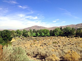
The Truckee Meadows is a valley in Northern Nevada, named for the Truckee River, which collects and drains all water in the valley. Truckee Meadows is also colloquially used as a name for the Reno-Tahoe-Fernley metropolitan CSA, even though the metro area includes areas outside this valley.
Mount Werner is a mountain summit in the Park Range of the Rocky Mountains of North America. The 10,570-foot (3,222 m) peak is located in Routt National Forest, 4.6 miles (7.4 km) east-southeast of the City of Steamboat Springs in Routt County, Colorado, United States. The mountain was renamed in 1964 in honor of skier Buddy Werner.

The North Saskatchewan River is a glacier-fed river that flows from the Canadian Rockies continental divide east to central Saskatchewan, where it joins with the South Saskatchewan River to make up the Saskatchewan River. Its water flows eventually into the Hudson Bay.
Sir Johns Run is an 8.9-mile-long (14.3 km) tributary stream of the Potomac River in Morgan County, West Virginia. For most of its course, Sir Johns Run is a shallow non-navigable stream. It rises on the eastern flanks of Cacapon Mountain and from its source, flows north with Cacapon Mountain to its west and Warm Spring Ridge to its east. During its flow northward through the valley, Sir Johns Run is joined by a number of smaller spring-fed streams. Sir Johns Run empties into the Potomac River at the small community of the same name, Sir Johns Run. The stream takes its name from Sir John St. Clair, a deputy quartermaster present during General Edward Braddock's expedition through the area during the French and Indian War.
The High Rockies, or high country, is a term for a region of the U.S. state of Colorado. It commonly includes Larimer County, Jackson County, Routt County, Grand County, Summit County, Eagle County, Lake County, and Pitkin County. Some notable towns there include Estes Park, Walden, Steamboat Springs, Grand Lake, Winter Park, Breckenridge, Dillon, Vail, Leadville, and Aspen. The geography of the High Rockies has some of the most rugged parts of the Rocky Mountains and consists of the Front Range and mountainous topography to the west, much of which is on or near the Continental Divide. Known for pine forests and winding roads, the former mining towns there have been reinvented by wilderness tourism such as hiking, cycling, fishing, and most especially both cross-country and alpine skiing. Notable ski resorts include Copper Mountain, Keystone Resort, Steamboat Ski Resort, Beaver Creek Resort, Buttermilk, Aspen Highlands, Snowmass, and Aspen Mountain. The High Rockies are also the location of Rocky Mountain National Park and Arapaho National Forest.
President most commonly refers to:

The Peace River, which flows from the Rocky Mountains in British Columbia to the Peace–Athabasca Delta and Lake Athabasca in Alberta, was navigable by late nineteenth and early twentieth century steamboats from the Rocky Mountain Falls at Hudson's Hope to Fort Vermilion, where there was another set of rapids, then via the lower Peace from Vermilion to Lake Athabasca. The Peace is part of the Mackenzie Basin, a larger river complex which includes the Athabasca, Slave, and Mackenzie Rivers.
Francis Patrick Armstrong was a steamboat captain in the East Kootenay region of British Columbia. He also operated steamboats on the Kootenay River in Montana and on the Stikine River in western British Columbia. Steam navigation in the Rocky Mountain Trench which runs through the East Kootenay region was closely linked to Armstrong's personality and career. In addition to being a steamboat captain, Armstrong was also a prospector, white-water boat pilot and guide in the Big Bend country of the Columbia River.
The Carrie Ladd was an important early steamboat on the lower Columbia and lower Willamette rivers. The vessel established the basic design of the Columbia River steamboat, which was later used throughout the Pacific Northwest, British Columbia, Alaska, and the Yukon.
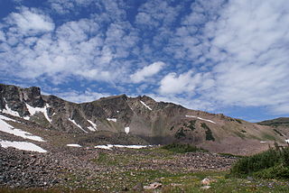
Mount Zirkel is the highest summit of the Park Range of the Rocky Mountains of North America. The prominent 12,185-foot (3,714 m) peak is located in the Mount Zirkel Wilderness of Routt National Forest, 25.9 miles (41.7 km) north-northeast of the City of Steamboat Springs, Colorado, United States, on the Continental Divide between Jackson and Routt counties. Mount Zirkel was named in honor of German geologist Ferdinand Zirkel.

Columbus Mountain, elevation 10,253 ft (3,125 m), is a summit in the Elkhead Mountains of northern Colorado, United States. The mountain is northwest of Steamboat Springs in the Routt National Forest.

Steamboats on the Colorado River operated from the river mouth at the Colorado River Delta on the Gulf of California in Mexico, up to the Virgin River on the Lower Colorado River Valley in the Southwestern United States from 1852 until 1909, when the construction of the Laguna Dam was completed. The shallow draft paddle steamers were found to be the most economical way to ship goods between the Pacific Ocean ports and settlements and mines along the lower river, putting in at landings in Sonora state, Baja California Territory, California state, Arizona Territory, New Mexico Territory, and Nevada state. They remained the primary means of transportation of freight until the advent of the more economical railroads began cutting away at their business from 1878 when the first line entered Arizona Territory.

Boulder Canyon, originally Devils Gate Canyon, is a canyon on the Colorado River, above Hoover Dam, now flooded by Lake Mead. It lies between Clark County, Nevada and Mohave County, Arizona. It heads at western end of the Virgin River Basin of Lake Mead, at about 36°09′05″N114°32′51″W. Boulder Canyon divides the Black Mountains into the Black Mountains of Arizona, and the Black Mountains of Nevada. Its mouth is now under the eastern end of the Boulder Basin of Lake Mead, between Canyon Point in Nevada and Canyon Ridge in Arizona. Its original mouth is now underneath Lake Mead between Beacon Rock and Fortification Ridge on the southern shore in Arizona.
Innovate Pro Wrestling is an American independent professional wrestling promotion based in Kingsport, Tennessee. The company was established in 2004 and until 2017 it was associated with the National Wrestling Alliance. During its time in the NWA, NWA Smoky Mountain Wrestling was considered the flagship promotion of the National Wrestling Alliance

Elk Mountain is a summit in Routt County, Colorado. The mountain lies to the northwest of Steamboat Springs and is easily seen from the city, especially from along Lincoln Avenue, Steamboat's main street. The mountain is also easily seen from Mount Werner, the home of the Steamboat Ski Resort.

Steamboat is an unincorporated community in Jackson County, Oregon, United States. It lies along Carberry Creek, a tributary of the Applegate River, in the Rogue River – Siskiyou National Forest. Slightly west of Steamboat is the Jackson–Josephine county border, and the border with California is about 6 miles (10 km) to the south.