Rowan County is a county in the U.S. state of North Carolina that was formed in 1753, as part of the British Province of North Carolina. It was originally a vast territory with unlimited western boundaries, but its size was reduced to 524 square miles (1,360 km2) after several counties were formed from Rowan County in the 18th and 19th centuries. As of the 2020 census, its population was 146,875. Its county seat, Salisbury, is the oldest continuously populated European-American town in the western half of North Carolina. Rowan County is located northeast of Charlotte, and is considered part of the Charlotte-Concord-Gastonia, NC-SC Metropolitan Statistical Area.

Iredell County is a county located in the U.S. state of North Carolina. As of the 2020 census, the population was 186,693. Its county seat is Statesville, and its largest community is Mooresville. The county was formed in 1788, subtracted from Rowan County. It is named for James Iredell, one of the first justices of the Supreme Court. Iredell County is included in the Charlotte-Concord-Gastonia, NC-SC Metropolitan Statistical Area, as defined by the Office of Management and Budget with data from the U.S. Census Bureau.

Guilford County is a county located in the U.S. state of North Carolina. At the 2020 census, the population was 541,299. In 2022, the population was estimated to be 546,101, making it the third-most populous county in North Carolina. The county seat, and largest community, is Greensboro. Since 1938, an additional county court has been located in High Point. The county was formed in 1771. Guilford County is included in the Greensboro-High Point, NC Metropolitan Statistical Area, which is also included in the Greensboro–Winston-Salem–High Point, NC Combined Statistical Area.
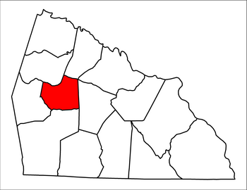
Alexander County is a county established in the U.S. state of North Carolina in 1847. As of the 2020 census, the population was 36,444. Its county seat is Taylorsville. Alexander County is part of the Hickory-Lenoir-Morganton, NC Metropolitan Statistical Area.
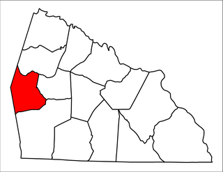
Mount Ulla Township is one of fourteen townships in Rowan County, North Carolina, United States. It is currently the smallest township in Rowan County by population.

Unity Township is one of fourteen townships in Rowan County, North Carolina, United States. The township had a population of 2,215 according to the 2010 census.

Cleveland Township is one of fourteen non-functioning county subdivisions (townships) in Rowan County, North Carolina that were established in 1868. The township had a population of 2,817 according to the 2010 census. The only incorporated municipality in Cleveland Township is the town of Cleveland. Residents are served by the Rowan–Salisbury School System and the township is home to Mt Ulla Elementary School.
Cherryville Township is a township in northwestern Gaston County, North Carolina, United States. As of the 2010 census it had a population of 16,500. It includes the incorporated city of Cherryville, the inactive incorporated town of Dellview, the unincorporated community of Tryon, and a portion of the town of High Shoals. It is represented on the Gaston County Board of Commissioners by Allen Fraley of Cherryville.

Turnersburg Township is a nonfunctioning administrative division in northeastern Iredell County, North Carolina, United States. Turnersburg township was established in 1868. The only major town in Turnersburg township is Harmony, which is also partially within Eagle Mills township.
Barringer Township is a non-functioning township in Iredell County, North Carolina, United States. By the requirements of the North Carolina Constitution of 1868, the counties were divided into townships, including sixteen in Iredell County.
Bethany Township is a non-functioning administrative division of Iredell County, North Carolina, United States. By the requirements of the North Carolina Constitution of 1868, the counties were divided into townships, which included Bethany township as one of sixteen townships in Iredell County.
Chambersburg Township is a township in Iredell County, North Carolina, United States. The 2010 United States Census reported a total population of 11,344.
Concord Township is a non-functioning administrative division of Iredell County, North Carolina, United States. By the requirements of the North Carolina Constitution of 1868, the counties were divided into townships, which included Concord township as one of sixteen townships in Iredell County.
Olin Township is a non-functioning administrative division of Iredell County, North Carolina, United States. By the requirements of the North Carolina Constitution of 1868, the counties were divided into townships, which included Olin township.
Sharpesburg Township is a non-functioning administrative division of Iredell County, North Carolina, United States. By the requirements of the North Carolina Constitution of 1868, the counties were divided into townships, which included Sharpesburg township as one of sixteen townships in Iredell county.

Cool Springs Township is a non-functioning administrative division of Iredell County, North Carolina, United States. By the requirements of the North Carolina Constitution of 1868, the counties were divided into townships, which included Cool Springs township as one of sixteen townships in Iredell County.
Eagle Mills Township is a rural, non-functioning subdivision of Iredell County, North Carolina, United States. By the requirements of the North Carolina Constitution of 1868, the counties were divided into townships, which included Eagle Mills. Eagle Mills Township was named for the town of Eagle Mills, which was established by Andrew Baggerly on Hunting Creek in 1848.
Bear Poplar is an unincorporated community mostly within Steele Township in Rowan County, North Carolina, United States. Some of the western part extends into neighboring Mount Ulla Township.
Mill Bridge is an unincorporated community and populated place officially registered as Mill Bridge in 1874. It is located primarily in Atwell Township and Steele Township in Rowan County, North Carolina, United States. With part extending into Mount Ulla Township. The prominent features include the Kerr Mill, Thyatira Presbyterian Church, and Millbridge Speedway.
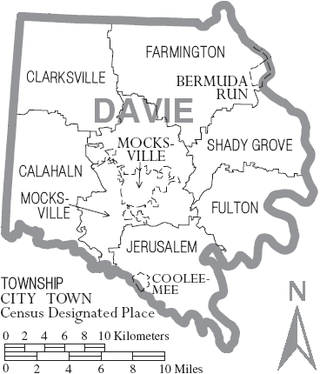
Calahaln Township is a non-functioning administrative division of Davie County, North Carolina, United States. By the requirements of the North Carolina Constitution of 1868, the counties were divided into townships, which included Calahaln township as one of sixteen townships in Davie County. Calahaln township is in western Davie County. The western border is the Iredell County line. The southern border is the South Yadkin River and Rowan County line. The northern and eastern borders are irregular and include portions of the Hunting Creek in on the southern end and Bear Creek on the northern end. The township was named for the Calahaln community, which was named for William Calahan or his descendants. William Calahan was in the area as early as 1778. Calahaln Mountain at 845 feet (258 m) is the highest point in Calahaln Township (35°55′32″N80°40′10″W.