Gold Hill, North Carolina

Last updated

Gold Hill, North Carolina
USA North Carolina location map.svg
Red pog.svg
Gold Hill, North Carolina
Usa edcp location map.svg
Red pog.svg
Gold Hill, North Carolina
Coordinates: 35°31′31″N80°20′43″W / 35.52528°N 80.34528°W / 35.52528; -80.34528
Country United States
State North Carolina
County Rowan
Area
[1]
  Total2.51 sq mi (6.49 km2)
  Land2.49 sq mi (6.44 km2)
  Water0.02 sq mi (0.05 km2)
Elevation
[2]
761 ft (232 m)
Population
 (2020)
  Total372
  Density149.52/sq mi (57.73/km2)
Time zone UTC-5 (Eastern (EST))
  Summer (DST) UTC-4 (EDT)
ZIP code
28071 [3]
Area code(s) 704 and 980
GNIS feature ID2812801 [2]

Gold Hill is an unincorporated community and census-designated place (CDP) in southeastern Rowan County, North Carolina, United States near the Cabarrus County line. It was first listed as a CDP in the 2020 census with a population of 372. [4] It is situated near the Yadkin River and is served by U.S. Highway 52 and Old Beatty Ford Road.

Contents

Mining

Gold was first discovered in what would become the town of Gold Hill in southeastern Rowan County in 1824. $6 million in gold was mined here prior to the Civil War and a mint was located in Charlotte as a result. [5] In the 1840s, Gold Hill was "a raucous mining camp town with a considerable number of saloons and brothels." [6] The Barnhardt shaft, named for Col. George Barnhardt [6] of the Reed Mine (NC State Historic Site) family, was opened in 1842[ citation needed ] and reached a depth of 435 feet. The Earnhardt/Randolph Mine Shaft was opened in 1843 across the street from the Barnhardt Mine and reached a depth of 850 feet becoming the deepest gold mine in the United States. The Barnhardt and Randolph mines together were described as "the richest and most productive gold mines east of the Mississippi". [6] Gold Hill was incorporated in 1843 and had a population of 3000 people and a total of 23 mines in the Gold Hill Mining District. The California Gold Rush and the American Civil War significantly reduced the mining activity. [6] Although some mining occurred in the years following the Civil War a greater resurgence of mining began with the purchase of the Gold Hill Mines and the establishment of 'The New Gold Hill Mining Company' based in London, England. Considerable profits were realized with gold being shipped to England during the period of 1880-1900. Production came to an end by 1915.[ citation needed ]

Tourist attraction

The town's first Founders' Day, which was not called by that name, took place in 1989 and was not intended to become an annual event, but it ended up being so popular that a steering committee was formed for the purpose of starting a foundation to find and preserve the town's heritage. The Historic Gold Hill and Mines Foundation, Inc. began in 1992, and that year, a second Founders' Day took place. Gold Hill Mines Historic Park began with a donation of 16 acres by Billie Johnson and was dedicated in 1993; by the 25th Founders' Day it was 70 acres. Founders' Day became an annual event on the fourth Saturday in September, and they were moved from the fire department to the park located at 735 St. Stephens Church Road. [6]

E.H. Montgomery General Store, Mauney’s Store, the jail and a rock wall date back to the 1840s. Several buildings were moved to and restored for what has been described as a "re-creation" of a historic village. A gas station built in 1928 was moved from U.S. 52 in 1998. The File Store from Craven, North Carolina near Salisbury was built in 1906 and moved to Gold Hill in 2001. A miner's cabin was moved to Gold Hill in 2011 and became a bakery. [6]

The Daniel Isenhour House and Farm was listed on the National Register of Historic Places in 2000. [7]

Demographics

Historical population
CensusPop.Note
2020 372
U.S. Decennial Census [8]
2020 [9]

2020 census

Gold Hill CDP, North Carolina – Demographic Profile
(NH = Non-Hispanic)
Race / EthnicityPop 2020 [9] % 2020
White alone (NH)33389.52%
Black or African American alone (NH)20.54%
Native American or Alaska Native alone (NH)71.88%
Asian alone (NH)00.00%
Pacific Islander alone (NH)00.00%
Some Other Race alone (NH)00.00%
Mixed Race/Multi-Racial (NH)225.91%
Hispanic or Latino (any race)82.15%
Total372100.00%

Note: the US Census treats Hispanic/Latino as an ethnic category. This table excludes Latinos from the racial categories and assigns them to a separate category. Hispanics/Latinos can be of any race.

Related Research Articles

<span class="mw-page-title-main">Rowan County, North Carolina</span> County in North Carolina, United States

Rowan County is a county in the U.S. state of North Carolina that was formed in 1753, as part of the British Province of North Carolina. It was originally a vast territory with unlimited western boundaries, but its size was reduced to 524 sq mi after several counties were formed from Rowan County in the 18th and 19th centuries. As of the 2020 census, its population was 146,875. Its county seat, Salisbury, is the oldest continuously populated European-American town in the western half of North Carolina. Rowan County is located northeast of Charlotte, and is considered part of the Charlotte–Concord–Gastonia, NC-SC Metropolitan Statistical Area.

<span class="mw-page-title-main">Mocksville, North Carolina</span> Town in North Carolina, United States

Mocksville is a town in Davie County, North Carolina, United States. The population was 5,900 at the 2020 census. I-40 leads west to Statesville and Hickory, and east to Winston-Salem and Greensboro. Route 64 heads east to Lexington, and west towards Statesville and Taylorsville. It is the county seat of Davie County.

<span class="mw-page-title-main">Enochville, North Carolina</span> CDP in North Carolina, United States

Enochville is a census-designated place (CDP) in Rowan County, North Carolina, United States. The population was 2,851 at the 2000 census.

<span class="mw-page-title-main">Dudley, North Carolina</span> Census-designated place in North Carolina, United States

Dudley is an unincorporated community and census-designated place (CDP) in Wayne County, North Carolina, United States, about 9 miles south of Goldsboro. It was first listed as a CDP in the 2020 census with a population of 826. Dudley is included in the Goldsboro, North Carolina Metropolitan Statistical Area.

Floyd Dale, shown on federal maps as Floydale, is an unincorporated community and census-designated place (CDP) in Dillon County, South Carolina, United States. It was first listed as a CDP in the 2020 census with a population of 421.

Deep Run is an unincorporated community and census-designated place (CDP) in southern Lenoir County, North Carolina, United States. It was first listed as a CDP in the 2020 census with a population of 572.

Grandy is an unincorporated community and census-designated place (CDP) in Currituck County, North Carolina, USA. It was first listed as a CDP in the 2020 census with a population of 2,776. It is located along US 158 between the Currituck Sound and the North River.

Beech Island is an unincorporated community and census-designated place (CDP) in Aiken County, South Carolina, United States. It was first listed as a CDP in the 2020 census with a population of 1,421.

<span class="mw-page-title-main">Barnardsville, North Carolina</span> Census-designated place in North Carolina, United States

Barnardsville is an unincorporated community and census-designated place (CDP) in Buncombe County, North Carolina, United States. It was first listed as a CDP in the 2020 census with a population of 559.

Spout Springs is a Census-designated place in Johnsonville Township of Harnett County, North Carolina, United States. It was first listed as a CDP in the 2020 census with a population of 11,040.

<span class="mw-page-title-main">Ketchuptown, South Carolina</span> Census-designated place in South Carolina, United States

Ketchuptown is a historic unincorporated community and census-designated place (CDP) located in Horry County, South Carolina, United States. Ketchuptown is at the intersection of Highways 23 and 99, about 9 miles (14 km) north of Aynor. As of the 2020 census, it had a population of 84.

Dacusville is a small unincorporated community and census-designated place (CDP) in Pickens County, South Carolina, United States. It is best known for its tractor show once a year in the month of September. The community also has an elementary school and a middle school. It was first listed as a CDP in the 2020 census with a population of 399.

<span class="mw-page-title-main">Seabrook, South Carolina</span> Census-designated place in South Carolina, United States

Seabrook is an unincorporated community and census-designated place (CDP) located in Beaufort County, South Carolina, United States. It was first listed as a CDP in the 2020 census with a population of 1,255.

<span class="mw-page-title-main">Conestee, South Carolina</span> Census-designated place in South Carolina, United States

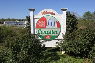
Conestee is an unincorporated community and census-designated place (CDP) in Greenville County, South Carolina, United States. It was first listed as a CDP in the 2020 census with a population of 904.

Briar Chapel is a planned community and census-designated place (CDP) in Chatham County, North Carolina, United States. It was first listed as a CDP in the 2020 census with a population of 5,108.

Carolina Meadows is a planned community and census-designated place (CDP) in Chatham County, North Carolina, United States. It was first listed as a CDP in the 2020 census with a population of 727.

Governors Club is a golf course community and census-designated place (CDP) in Chatham County, North Carolina, United States. It was first listed as a CDP in the 2020 census with a population of 1,969.

Roberdel, also known as Roberdell, is an unincorporated community and census-designated place (CDP) in Richmond County, North Carolina, United States. It was first listed as a CDP in the 2020 census with a population of 246.

North Santee is a census-designated place (CDP) in Clarendon County, South Carolina, United States. It was first listed as a CDP prior to the 2020 census with a population of 749.

Olympia is an urban unincorporated area and census-designated place (CDP) in Richland County, South Carolina, United States. It was first listed as a CDP prior to the 2020 census with a population of 1,087.

References

  1. "ArcGIS REST Services Directory". United States Census Bureau. Retrieved September 20, 2022.
  2. 1 2 U.S. Geological Survey Geographic Names Information System: Gold Hill, North Carolina
  3. "Gold Hill NC ZIP Code". zipdatamaps.com. 2023. Retrieved February 17, 2023.
  4. "Gold Hill CDP, North Carolina". United States Census Bureau . Retrieved April 7, 2022.
  5. Martin, Jonathan. "Rowan County (1753)". North Carolina History Project. Retrieved May 21, 2019.
  6. 1 2 3 4 5 6 Wineka, Mark (September 16, 2014). "Gold Hill's history, ambiance always worth the trip". Salisbury Post . Retrieved June 12, 2019.
  7. "National Register Information System". National Register of Historic Places . National Park Service. July 9, 2010.
  8. "Decennial Census of Population and Housing by Decades". US Census Bureau.
  9. 1 2 "P2 HISPANIC OR LATINO, AND NOT HISPANIC OR LATINO BY RACE – 2020: DEC Redistricting Data (PL 94-171) – Gold Hill, North Carolina". United States Census Bureau .