Sterkfontein Dam

Last updated
Sterkfontein Dam
South Africa-Sterkfontein Dam-01.jpg
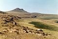
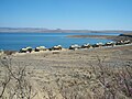
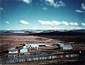
Sterkfontein Dam Reservoir seen from the R74
South Africa relief location map.svg
Red pog.svg
Location of Sterkfontein Dam in South Africa
Official nameSterkfontein Dam
Location Free State
Coordinates 28°26′54″S29°01′22″E / 28.4484°S 29.0228°E / -28.4484; 29.0228 Coordinates: 28°26′54″S29°01′22″E / 28.4484°S 29.0228°E / -28.4484; 29.0228
Construction began1969
Opening date1980 (renovated 1986) [1]
Dam and spillways
Type of dam Earth fill dam
Impounds Nuwejaarspruit [1]
Height97 metres (320 ft) [1]
Length3,060 metres (3,350 yd) [1]
Dam volume19,800,000 m3 (25,900,000 cu yd)
Spillway capacity0 m3/s (0 cu ft/s)
Reservoir
CreatesSterkfontein Dam Reservoir
Total capacity2,616,000 ML (2,121,000 acre⋅ft) [1]
Catchment area 195 km2 (75 sq mi)
Surface area69.37 km2 (26.78 sq mi) [1]
Maximum length18.8 km (11.7 mi)
Normal elevation1,708 m (5,604 ft)

The Sterkfontein Dam, located just outside the town of Harrismith, in the Free State, province of South Africa, is part of the Tugela-Vaal Water Project and the Drakensberg Pumped Storage Scheme, and located on the Nuwejaarspruit, a tributary of the Wilge River in the upper catchment area of the Vaal River. [2] It is the second highest dam wall in South Africa and its highest earth fill dam.

Contents

Background

History

The rapid economic expansion of the greater Johannesburg area in the 1960s and 70s put its water supply under long term threat and it was decided to redirect water from the large Tugela River which was going largely un-used into the sea and store it in large strategic water storage reservoir with very low evaporation. The initial site chosen for this project was in the adjacent valley to the west on the Elands River. This was the preferred option from an engineering aspect because it would involve a smaller dam wall. However shortly before construction was about to start the site on the Nuwejaarspruit was selected for political reasons because it avoided the partial flooding of the newly planned Bantustan of Qwaqwa in Phuthadichaba. It could have meant this strategic national resource could have been located in a "foreign country" which would have been unacceptable as seen from the perspective of the current government in that time.

Construction

Construction began in 1969 and the first phase was commissioned in 1977 and comprised a 69-metre (226 ft) high earthfill embankment 2,290 metres (7,510 ft) long with no spillway. After completion of the first phase the decision was made to immediately continue with the final phase and it was subsequently raised in 1980 to its current height of 93 metres (305 ft) with a crest length of 3,060 metres (10,040 ft) and a full supply capacity of 2,656 million cubic metres (2,153,000 acre⋅ft). At full supply, it has a surface area of no more than 70 km2. The extended dam was commissioned in 1980, and has a capacity of 2,616,950 cubic metres (2,121.60 acre⋅ft), with a surface area of only 67.26 square kilometres (25.97 sq mi), the dam wall is 93 metres (305 ft) high. The total construction period was 11 years. The Sterkfontein Dam was designed and constructed by the Department of Water Affairs. The dam mainly serves for domestic and industrial use and its hazard potential has been ranked high (3).[ clarification needed ]

Naming

The dam was named after one of the farms located in the vicinity of its construction. The temporary township for the construction workers was built on the Sterkfontein farm. The word sterkfontein means strong spring in Afrikaans.

Characteristics

Earth Fill Dam Wall

The wall is an earth gravity type. The dam wall contains 19.8 million cubic metres (700×10^6 cu ft) of material making it the largest dam wall in South Africa with regard to volume. The reservoir is impounded by two walls. The second wall is 600 metres (2,000 ft) long and contains 1.04 million cubic metres (37×10^6 cu ft) of material.

No spillway

The dam is unique as the majority of water is sourced by diverting flow from the upper reaches of the Tugela river. This water would otherwise be underutilised and flow into the ocean. The dam was not built on a river but instead, it is sited on what can at best be classed as a large stream in the upper reaches of a valley on the Nuwejaarspruit. The catchment area of the dam is less than three times the water surface area of the dam and therefore not risk to a flood. For this reason the main dam wall does not have the need for a spillway. Any excess rainwater can be safely ejected from its outlet valves. The advantage of this location is the Dam is a highly effective reservoir, since it has the depth to store a large amount of water, with very little loss to evaporation. The Vaal Dam lake (reservoir) by comparison has a large surface area and is relatively shallow, which results in a higher rate of evaporation. It would take 17 years of rainfall to fill the dam. But capturing rainfall was not an important intent behind this project. It was built to capture water from the Tugela river and deliver it into the Vaal system.

Pumped Hydro Storage Scheme

Map of the Pumped Storage Scheme Drakensberg Hydropower.png
Map of the Pumped Storage Scheme

The dam receives its water via the Tugela-Vaal Water Project later renamed the Drakensberg Pumped Storage Scheme which is a 1,000 MW pumped hydro storage scheme involving the net transfer of up to 630 million cubic metres (510,000 acre⋅ft) of water from KwaZulu-Natal. This is stored in the Sterkfontein Dam and released to the Vaal Dam via the Wilge River when needed.

A dam within a dam

The weir separating the Sterkfontein Dam from the Driekloof Dam Sterkfontein Dam Weir.jpg
The weir separating the Sterkfontein Dam from the Driekloof Dam

The Driekloof Dam which is inside the Sterkfontein Dam, is regarded as a separated dam and reservoir, and is not included in the above figures. It is essentially a dam within a dam. Driekloof Dam is the upper storage reservoir of the Drakensberg Pumped Storage Scheme. If the Sterkfontein Dam were to be empty the Driekloof reservoir would retain the water for the pumped storage scheme to operate unimpeded. When Sterkfontein Dam is at full capacity the Driekloof Dam is submerged up to the top of its spillway.

Third largest dam in South Africa

This is the 3rd largest dam in South Africa in terms of water capacity and it is slightly larger than Vaal Dam.

Protected areas

The Sterkfontein Dam Nature Reserve is a protected area located by the dam. [3]

See also

Related Research Articles

<span class="mw-page-title-main">Warragamba Dam</span> Dam in Warragamba, New South Wales

Warragamba Dam is a heritage-listed dam in the outer South Western Sydney suburb of Warragamba, Wollondilly Shire in New South Wales, Australia. It is a concrete gravity dam, which creates Lake Burragorang, the primary reservoir for water supply for the city of Sydney. The dam wall is located approximately 65 kilometres (40 mi) W of Sydney central business district, 4½ km SW of the town of Wallacia, and 1 km NW of the village of Warragamba.

<span class="mw-page-title-main">Vaal Dam</span> Dam in South Africa

The Vaal Dam in South Africa was constructed in 1938 and lies 77 km south of OR Tambo International Airport, Johannesburg. The lake behind the dam wall has a surface area of about 320 square kilometres (120 sq mi) and is 47 meters deep. The Vaal Dam lies on the Vaal River, which is one of South Africa's strongest-flowing rivers. Other rivers flowing into the dam are the Wilge River, Klip River, Molspruit and Grootspruit. It has over 800 kilometres (500 mi) of shoreline and is South Africa's second biggest dam by area and the fourth largest by volume.

<span class="mw-page-title-main">Lesotho Highlands Water Project</span> Water Supply and hydropower project by South Africa and Lesotho

The Lesotho Highlands Water Project (LHWP) is an ongoing water supply project with a hydropower component, developed in partnership between the governments of Lesotho and South Africa. It comprises a system of several large dams and tunnels throughout Lesotho and delivers water to the Vaal River System in South Africa. In Lesotho, it involves the rivers Malibamatso, Matsoku, Senqunyane, and Senqu. It is Africa's largest water transfer scheme.

Mont-aux-Sources is a mountain in Southern Africa, forming one of the highest portions of the Drakensberg Range. It is mostly within Lesotho, with parts in the KwaZulu-Natal and Free State provinces of South Africa.

<span class="mw-page-title-main">Wivenhoe Dam</span> Dam in South East Queensland

The Wivenhoe Dam is a rock and earth-fill embankment dam with a concrete spillway across the Brisbane River in South East Queensland, Australia. The dam wall is located about 80 kilometres (50 mi) by road from the centre of Brisbane. The primary purpose of the dam is the supply of potable water for the Brisbane and Ipswich regions. The dam also provides for flood mitigation control, hydroelectricity, and recreation. The impounded reservoir is called Lake Wivenhoe and the dam, the lake and a narrow strip of surrounding land forms a locality also called Lake Wivenhoe.

<span class="mw-page-title-main">Split Rock Dam</span> Dam in North West Slopes, New South Wales

Split Rock Dam is a minor ungated concrete faced rock fill embankment dam with concrete chute spillway across the Manilla River upstream of Manilla in the north-western slopes region of New South Wales, Australia. The dam's purpose includes flood mitigation, irrigation, water supply and conservation. The impounded reservoir is called Split Rock Reservoir.

<span class="mw-page-title-main">Splityard Creek Dam</span> Dam in South East Queensland

The Splityard Creek Dam is a rock and earth-fill embankment dam with an un-gated spillway across the Pryde Creek that is located in the South East region of Queensland, Australia. The sole purpose of the dam is for the generation of hydroelectricity. The impounded reservoir is called the Splityard Creek Reservoir.

The Ingula Pumped Storage Scheme is a pumped-storage power station in the escarpment of the Little Drakensberg range straddling the border of the KwaZulu-Natal and Free State provinces, South Africa. It is about 22 km (14 mi) North-East of Van Reenen.

<span class="mw-page-title-main">Kilburn Dam</span> Dam in KwaZulu-Natal, South Africa

The Kilburn Dam, an earth-fill type dam and part of the Tugela-Vaal Water Project and Drakensberg Pumped Storage Scheme, is located 500 metres (1,600 ft) lower than the Sterkfontein Dam, on the Mnjaneni River, near Bergville, KwaZulu-Natal, province of South Africa. The dam was commissioned in 1981, has a capacity of 36,700 cubic metres (1,300,000 cu ft), and a surface area of 207 hectares, the dam wall is 48 metres (157 ft) high. The main purpose of the dam assembly is to serve for the generation of hydro-electricity and its hazard potential has been ranked high (3).

<span class="mw-page-title-main">Driekloof Dam</span> Dam in Free State, South Africa

Driekloof Dam is a small section of the Sterkfontein Dam, Free State, South Africa. A section of the Sterkfontein Dam reservoir is isolated after the construction of Driekloof Dam, this small reservoir has a capacity of 35.6 million cubic metres (28,900 acre⋅ft)., together with the Kilburn Dam almost 500 metres (1,600 ft) lower, Driekloof forms part of Eskom's Drakensberg Pumped Storage Scheme and Tugela-Vaal Water Project, and provides for up to 27.6 gigawatt-hours (99 TJ) of electricity storage in the form of 275 million cubic metres of water. The water is pumped to Driekloof during times of low national power consumption and released back into Kilburn through four 250 megawatts (340,000 hp) turbine generators in times of high electricity demand.

<span class="mw-page-title-main">Drakensberg Pumped Storage Scheme</span> Dam in Free State & KwaZulu-Natal

The Drakensberg Pumped Storage Scheme is an energy storage facility built in the South African provinces of Free State and KwaZulu-Natal starting in 1974 and completed by 1981.

<span class="mw-page-title-main">Woodstock Dam</span> Dam in KwaZulu-Natal

Woodstock Dam is located on the upper reaches of the Tugela, KwaZulu-Natal province of South Africa and is the main source of water for the Thukela-Vaal Transfer Scheme. The dam was commissioned in 1982, has a storage capacity of 373.26 million cubic metres, and a surface area of 29.129 square kilometres (11.247 sq mi), the dam wall is 54 metres (177 ft) high. The dam serves mainly for municipal and industrial water supply purposes and its hazard potential has been ranked high (3).

<span class="mw-page-title-main">Siah Bishe Pumped Storage Power Plant</span> Dam in Chalus

The Siah Bisheh Pumped Storage Power Plant, also spelled Siyāhbisheh and Siah Bishe, is located in the Alborz Mountain range near the village of Siah Bisheh and 48 km (30 mi) south of Chalus in Mazandaran Province, Iran. The power plant uses the pumped-storage hydroelectric method to generate electricity during periods of high energy demand, making it a peaking power plant, intended to fulfill peak electricity demand in Tehran 60 km (37 mi) to the south. When complete it will have an installed generating capacity of 1,040 megawatts (1,390,000 hp) and a pumping capacity of 940 megawatts (1,260,000 hp). Planning for the project began in the 1970s and construction began in 1985. It was delayed from 1992 until 2001 and the first generator went online in May 2013. The remaining generators were commissioned by 1 September 2015. The power plant is the first pumped-storage type in Iran and will also use the country's first concrete-face rock-fill dam – two of them.

<span class="mw-page-title-main">Entracque Power Plant</span> Dam in Entracque

The Entracque Power Plant, also known as The Upper Gesso Plant, is a pumped-storage hydroelectric power station located in Valle Gesso just south of Entracque, Italy. The power station contains pump-generators for two co-located but hydraulically separated power schemes; the Chiotas-Piastra Plant and Rovina-Piastra Plant. Both plants use separate upper reservoirs but use Lago della Piastra as their common lower reservoir. To produce power, water is released from the upper reservoirs to the power station located at the lower reservoir. The pump-generators re-fill the reservoirs and the process repeats as needed. The Chiotas' upper reservoir, Lago del Chiotas, is located much higher in the valley and larger than Rovina's Lago della Rovina which affords it the ability to produce more electricity. The installed capacity of Chiotas is 1,184 megawatts (1,588,000 hp) with a hydraulic head of 1,048 m (3,438 ft) while Rovina has an installed capacity of 133.67 megawatts (179,250 hp) and a head of 598 metres (1,962 ft). Construction on the plant began in 1962 and operations started in 1982. It is owned and operated by Enel.

<span class="mw-page-title-main">Wilge River</span> River in South Africa

The Wilge River is a tributary of the Vaal River in central South Africa. This river is important as part of the Tugela-Vaal Water Transfer Scheme where water is transferred from the Tugela River basin to the Vaal River basin.

<span class="mw-page-title-main">North-South Carrier</span> Water pipeline in Botswana

The North-South Carrier (NSC) is a pipeline in Botswana that carries raw water south for a distance of 360 kilometres (220 mi) to the capital city of Gaborone. Phase 1 was completed in 2000. Phase 2 of the NSC, under construction, will duplicate the pipeline to carry water from the Dikgatlhong Dam, which was completed in 2012. A proposed extension to deliver water from the Zambezi would add another 500 to 520 kilometres to the total pipeline length. The NSC is the largest engineering project ever undertaken in Botswana.

Grahamstown Dam is a major off-stream earthfill Embankment dam with a controlled labyrinth spillway and baffle chute that stores water from the Williams River. The dam is located north of Newcastle and within the Port Stephens Council local government area in the Lower Hunter Region of New South Wales, Australia. The dam's main purpose is water supply; it provides about 40 per cent of the potable water for the Hunter region; and is the Hunter's largest drinking water supply dam.

Rydal Dam is a minor ungated homogeneous earthfill embankment dam with a fuse plug uncontrolled open channel spillway across an off stream storage, located near Rydal in the Central Tablelands region of New South Wales, Australia. The dam's purpose is to provide water storage for Delta power stations at Wallerawang and Mount Piper. The impounded reservoir is also called the Rydal Dam.

<span class="mw-page-title-main">Tugela Vaal Transfer Scheme</span>

The Tugela Vaal water Transfer Scheme is an irrigation project developed in the Drakensberg mountains at the Oliviershoek Pass in South Africa.

References

  1. 1 2 3 4 5 6 "STERKFONTEIN DAM". Department of Water Affairs and Forestry. Retrieved 2008-10-22.
  2. Upper Vaal WMA 8
  3. Free State Tourism - Sterkfontein Dam Nature Reserve
External image
Searchtool.svg The weir separating the Driekloof Dam reservoir from the Sterkfontein Dam reservoir. at Rand Water