Empire is an unincorporated community and census-designated place (CDP) in Washoe County, Nevada, with a population estimated at 65 (2021). It is part of the Reno–Sparks Metropolitan Statistical Area; before the 2010 census, it was part of the Gerlach–Empire census-designated place. The nearest town, Nixon, is 60 miles (97 km) to the south on a reservation owned by the Pyramid Lake Paiute Tribe.

The Pah Rah Range is a mountain range located in western Nevada in Washoe County just to the northeast of Reno. It is a hook shaped range with the main eastern portion oriented northwest–southeast, approximately 20 miles (32 km) long. The northwest flowing Cottonwood Creek in Warm Springs Valley is bounded on three sides by the range. To the south and east the Truckee River forms the boundary and Pyramid Lake is at the northeast. Spanish Springs Valley north of Reno forms the southwest margin. To the north, the narrow Mullen Pass separates the Pah Rah Range from the Virginia Mountains.

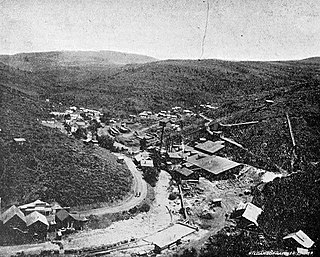
Delamar, Nevada, nicknamed The Widowmaker, is a ghost town in central eastern Nevada, USA along the east side of the Delamar Valley. During its heyday, primarily between 1895 and 1900, it produced $13.5 million in gold.

Midas is a small unincorporated community in Elko County, Nevada. Although its population has fluctuated greatly over the years and it often appears on internet ghost town lists, it has never been completely abandoned, and one can meet many of the living citizenry at the aptly named Ghost Town Saloon, its sole business. Alongside Jarbidge, the town was known as one of the biggest twentieth-century gold mining towns in Elko County.
Blair, Nevada is a mining ghost town in Esmeralda County, Nevada.
The Delamar Mountains are a mountain range in Lincoln County, Nevada, named after Captain Joseph Raphael De Lamar. The range extends for approximately 50 miles (80 km) in a NNE–SSW orientation with a width of about 11 miles (18 km). Surrounding ranges include the Burnt Springs Range and the Chief Range to the north, the Clover Mountains and Meadow Valley Mountains to the east and the Sheep Range and South Pahroc Range on the west. The Delamar Valley lies to the west, the Kane Springs Valley to the east and the Coyote Springs Valley lies to the south of the range.
De Lamar is a ghost town in Owyhee County, Idaho, United States. Its elevation is 5,463 ft (1,665 m), and it is approximately 6 mi (9.7 km) west of Silver City. The community lies within an area governed by the Bureau of Land Management.
Poeville, also known as Peavine until 1863, is the site of a historical mining town, established in 1864. John Poe, a professional promoter from Michigan allegedly related to Edgar Allan Poe, discovered rich gold and silver veins in 1862 on the slopes of Peavine Mountain. After the discovery of ore, Poe announced that the veins comprised the next Comstock Lode; he presented extracted ore at the state fair of 1864 as rich in content. As a result, the former mining camp, called Poe City (Poeville) or Podunk (Poedunk), grew to 200 people by 1864. Ore production in the mining district and population peaked around 1873-1874 with several hundred people living in town, supported by three hotels and a post office. The post office, named "Poeville", operated between September 1, 1874, and March 24, 1878.
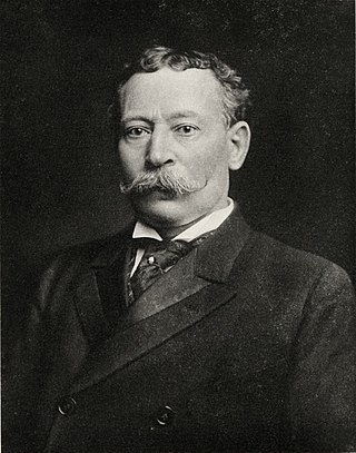
Joseph Raphael De Lamar was a prominent mine owner and operator in the western United States and Canada, as well as a financier and speculator, from the late 1870s until his death in 1918.

El Dorado Canyon is a canyon in southern Clark County, Nevada famed for its rich silver and gold mines. The canyon was named in 1857 by steamboat entrepreneur Captain George Alonzo Johnson when gold and silver was discovered here. It drains into the Colorado River at the former site of Nelson's Landing.

Fairview is a ghost town in Churchill County, Nevada, in the United States of America.
Lander is a ghost town in Lander County in Nevada in the United States. The site is approximately 24 miles southeast of Battle Mountain.
Thorne, Nevada is a rail junction and former town located in Mineral County, Nevada.
Wahmonie was a mining town in Nevada. It was established as a gold mining camp in February 1928 and had a population of 500 by March. Peak population was reached that summer, with between 1000 and 1500 residents. Gold was not found in sufficient quantity to sustain the place, and the site was quickly abandoned. The post office was in operation from April 1928 until April 1929. Wahmonie was the last large mining rush in Nevada. The location was also known as Horn Silver Mine.
Eagleville is a former populated place in Mineral County, Nevada that is now a ghost town.
White Plains is a ghost town in Churchill County, in the U.S. state of Nevada.
Omco is an extinct town in Mineral County, in the U.S. state of Nevada. The GNIS classifies it as a populated place.
Johnnie is a populated place in Nye County, in the U.S. state of Nevada about 15 miles north of Pahrump.
Lodi is an extinct town in Nye County, in the U.S. state of Nevada. The GNIS classifies it as a populated place.

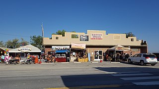
Bullionville is a ghost town in Lincoln County, Nevada, United States, 1/4 mile east of U.S. Route 93, one mile north of Panaca and 10 miles (16 km) south of Pioche. The town prospered between 1870 and 1882, and is now abandoned.


