
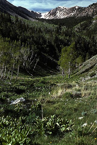
Wheeler Peak is the tallest mountain in the Snake Range and in White Pine County, in Nevada, United States. The summit elevation of 13,065 feet (3,982 m) makes it the second-highest peak in Nevada, just behind Boundary Peak. With a topographic prominence of 7,563 feet (2,305 m), Wheeler Peak is the most topographically prominent peak in White Pine County and the second-most prominent peak in Nevada, just behind Mount Charleston. The mountain is located in Great Basin National Park and was named for George Wheeler, leader of the Wheeler Survey of the late 19th century.
The Desatoya Mountains are located in central Nevada in the western United States, approximately 117 miles east of Reno by road. The range runs in a southwest-northeasterly direction along the border of Churchill and Lander counties, reaching a maximum elevation of 9,978 feet (3,041 m) at Desatoya Peak near Rock Creek Canyon.
The Schell Creek Range is a linear mountain range in central White Pine County, in east-central Nevada. Its length is approximately 132 miles (212 km) in a north-south direction. Most of the range is contained within the Humboldt-Toiyabe National Forest, with some of the range also included in the High Schells Wilderness.

Fort Churchill State Historic Park is a state park of Nevada, United States, preserving the remains of a United States Army fort and a waystation on the Pony Express and Central Overland Routes dating back to the 1860s. The site is one end of the historic Fort Churchill and Sand Springs Toll Road. The park is in Lyon County south of the town of Silver Springs, on U.S. Route 95 Alternate, eight miles (13 km) south of U.S. Route 50. Fort Churchill was designated a National Historic Landmark in 1961. A 1994 park addition forms a corridor along the Carson River.

U.S. Route 50 (US 50) is a transcontinental highway in the United States, stretching from West Sacramento, California, in the west to Ocean City, Maryland, on the east coast. The Nevada portion crosses the center of the state and was named "The Loneliest Road in America" by Life magazine in July 1986. The name was intended as a pejorative, but Nevada officials seized it as a marketing slogan. The name originates from large desolate areas traversed by the route, with few or no signs of civilization. The highway crosses several large desert valleys separated by numerous mountain ranges towering over the valley floors, in what is known as the Basin and Range province of the Great Basin.

Crystal Springs is a ghost town in the Pahranagat Valley region of Lincoln County, Nevada in the United States. The ghost town is located at the junction of State Route 318 and State Route 375, just northwest of U.S. Route 93. It is a popular destination for passersby who want to visit the towns of Hiko and Rachel. The namesake of the ghost town, the Crystal Springs, lies nearby; it is a large group of marshes and springs along the White River. Crystal Springs provides irrigation for multiple nearby ranches and farms, some of which lie over 5 miles away from the springs.
Star City was a silver-mining boom town in present-day Pershing County, Nevada. It was located in the Star Mining District. It is now a ghost town.

Strawberry is a small unincorporated community on the South Fork American River, 3.25 miles (5 km) south-southwest of Pyramid Peak, along U.S. Route 50 in the foothills of the Sierra Nevada. The sign on the highway reads population 50.
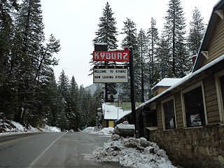
Kyburz is a small unincorporated community in El Dorado County, California. It is located along the South Fork of the American River and U.S. Route 50, and is surrounded by the Eldorado National Forest. Its elevation is 4058 feet above sea level.
Meyers is a small unincorporated community in El Dorado County, California, United States, along U.S. Route 50 in the northern Sierra Nevada. It is 6 miles (10 km) south of South Lake Tahoe in the Lake Tahoe area and lies at an elevation of 6,352 feet. Established in 1851, Meyers started out as a stagecoach stop, trading post and Pony Express station. The town is now registered as California Historical Landmark #708. It serves as a popular stop on the way into and out of the Tahoe Basin for travelers on Highways 50 and 89.
Rescue, formerly Green Valley, El Dorado County, California, is an unincorporated community in El Dorado County, California. It is located north-northwest of Shingle Springs and north-northeast of Cameron Park. The zip code is 95672, and Rescue is located in area code 530. The town lies at an elevation of 1214 feet.
Gandy is a unincorporated community in the northwestern corner of Millard County, Utah, United States, located just east of the Nevada-Utah state line.
The Overland Trail was a stagecoach and wagon trail in the American West during the 19th century. While portions of the route had been used by explorers and trappers since the 1820s, the Overland Trail was most heavily used in the 1860s as a route alternative to the Oregon, California, and Mormon trails through central Wyoming. The Overland Trail was famously used by the Overland Stage Company owned by Ben Holladay to run mail and passengers to Salt Lake City, Utah, via stagecoaches in the early 1860s. Starting from Atchison, Kansas, the trail descended into Colorado before looping back up to southern Wyoming and rejoining the Oregon Trail at Fort Bridger. The stage line operated until 1869 when the completion of the First transcontinental railroad eliminated the need for mail service via stagecoach.
Stagecoach is an unincorporated community and census-designated place (CDP) in Lyon County, Nevada, United States, located east of Reno. Its name is likely derived from its place as the Overland Stagecoach station at Desert Well. Typically, the mail that was heading towards California was delivered on a steamship through Panama. But in 1857, the Overland mail company was created, and the Desert Well station was a dual stop for both the stagecoach line and the Pony Express.

Sunnyside is a small unincorporated community in the White River Valley of eastern Nevada, near the southern terminus of the Egan Range. The site is located on State Route 318 approximately 31 miles by road south of Lund in White Pine County, the closest town, and 63 miles by road north of Hiko in Lincoln County.
Schellbourne, formerly known as Fort Schellbourne and Schell Creek Station is a ghost town located in the Schell Creek Range in White Pine County in Nevada, United States, located 43 miles (69 km) north of Ely. The town was a stopover along the Central Overland Route, Pony Express and original routing of the Lincoln Highway. It is today Nevada Historical Marker number 51. The site was listed on the National Register of Historic Places in 1972. Its boundaries were increased in 1977.

Fairview is a ghost town in Churchill County, Nevada, in the United States of America.
Eightmile is a locale on the Goshute Indian Reservation in White Pine County, Nevada. It is located along Spring Creek.
Spring Creek formerly known as West Creek, and Round Valley Creek, is a stream, tributary to West Deep Creek in White Pine County, Nevada with its source in Juab County, Utah.

Crystal Springs hot springs is a system of geothermal springs and seeps near Ash Springs, located at the site of a ghost town, Crystal Springs, Nevada. Several marshes and springs are located along the White River.


