The Weald is an area of South East England between the parallel chalk escarpments of the North and the South Downs. It crosses the counties of Hampshire, Surrey, West Sussex, East Sussex, and Kent. It has three parts, the sandstone "High Weald" in the centre, the clay "Low Weald" periphery and the Greensand Ridge, which stretches around the north and west of the Weald and includes its highest points. The Weald once was covered with forest and its name, Old English in origin, signifies "woodland". The term is still used, as scattered farms and villages sometimes refer to the Weald in their names.

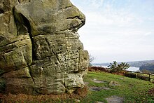
High Rocks is a 3.2-hectare (7.9-acre) geological Site of Special Scientific Interest west of Tunbridge Wells in East Sussex and Kent. It is a Geological Conservation Review site.

Brighton to Newhaven Cliffs is a 165.4-hectare (409-acre) biological and geological Site of Special Scientific Interest and Geological Conservation Review site, which stretches along the coast between Brighton and Newhaven in East Sussex. An area of 16.4 hectares is the Castle Hill, Newhaven Local Nature Reserve

Hastingford Cutting is a 0.04-hectare (0.099-acre) geological Site of Special Scientific Interest south of Crowborough in East Sussex. It is a Geological Conservation Review site.

Winchelsea Cutting is a 0.15-hectare (0.37-acre) geological Site of Special Scientific Interest on the southern outskirts of Winchelsea in East Sussex. It is a Geological Conservation Review site.

Turners Hill SSSI is a 0.2-hectare (0.49-acre) geological Site of Special Scientific Interest in Turners Hill in West Sussex. It is a Geological Conservation Review site.

The Tunbridge Wells Sand Formation is a geological unit which forms part of the Wealden Group and the uppermost and youngest part of the unofficial Hastings Beds. These geological units make up the core of the geology of the Weald in the English counties of West Sussex, East Sussex and Kent.

Southern Sandstone is a local name for the Ardingly Sandstone of southeast England, a soft sandstone of Cretaceous age separating the Tunbridge Wells Sands from the overlying Grinstead Clay. The outcrops in the Weald of Kent are the rock climbing crags closest to London and are probably the most heavily climbed in the UK.
The geology of West Sussex in southeast England comprises a succession of sedimentary rocks of Cretaceous age overlain in the south by sediments of Palaeogene age. The sequence of strata from both periods consists of a variety of sandstones, mudstones, siltstones and limestones. These sediments were deposited within the Hampshire and Weald basins. Erosion subsequent to large scale but gentle folding associated with the Alpine Orogeny has resulted in the present outcrop pattern across the county, dominated by the north facing chalk scarp of the South Downs. The bedrock is overlain by a suite of Quaternary deposits of varied origin. Parts of both the bedrock and these superficial deposits have been worked for a variety of minerals for use in construction, industry and agriculture.
Stone SSSI is a 0.12-hectare (0.30-acre) geological Site of Special Scientific Interest in Stone in Buckinghamshire. It is listed by the Joint Nature Conservation Committee as a Geological Conservation Review site.

Pembury Cutting and Pit is a 1.6-hectare (4.0-acre) geological Site of Special Scientific Interest east of Tunbridge Wells in Kent. It is a Geological Conservation Review site.

Southborough Pit is a 1.1-hectare (2.7-acre) geological Site of Special Scientific Interest in Tunbridge Wells in Kent. It is a Geological Conservation Review site.

Scaynes Hill is a 0.04-hectare (0.099-acre) geological Site of Special Scientific Interest north-west of Newick in East Sussex. It is a Geological Conservation Review site.
Coppedhall Hanger is a 0.6-hectare (1.5-acre) geological Site of Special Scientific Interest north of Billingshurst in West Sussex. It is a Geological Conservation Review site.

Warnham SSSI is a 28.5-hectare (70-acre) geological Site of Special Scientific Interest north of Horsham in West Sussex. It is a Geological Conservation Review site.

Freshfield Lane is a 17-hectare (42-acre) geological Site of Special Scientific Interest east of Haywards Heath in West Sussex. It is a Geological Conservation Review site.

Philpot's and Hook Quarries is a 2.6-hectare (6.4-acre) geological Site of Special Scientific Interest south-west of Sharpthorne in West Sussex. It is a Geological Conservation Review site.

Perry Copse Outcrop is a 0.2-hectare (0.49-acre) geological Site of Special Scientific Interest in Fernhurst in West Sussex. It is a Geological Conservation Review site.