Unlike the scarp top, the steeply sloping chalk grassland of the escarpment has been spared modern farming ploughing, fertilising and spraying of herbicides. Instead the area has been used for traditional low-level animal grazing and as a consequence the site is still pristine chalk grassland, which has created a ten kilometre stretch of wild flower meadows. Such areas have been described as Europe's tropical rainforests and the National Trust tell us, "They're home to an incredibly rich and diverse range of plant and insect life". Up to 40 species of flowering plants can be found in one square metre of chalk grassland.[4]
The particular character of this range of hills is their north facing aspect, meaning they can be shadowy and receive less sunlight. There is glaucous sedge, autumn gentian, marjoram and squinancywort. There are several species of wild, native orchid and the area is rich in mosses and liverworts. The botanical richness means it also supports biodiverse fauna. There are also areas of ancient woodland and ancient scrub and the site has a rich community of breeding birds, and a number of red listed bird species in the highest conservation concern category.[5]
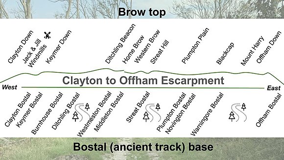
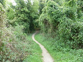
Escarpment bostals
There are at least eleven named bostals, ancient paths, that run up and down the scarp and many more unnamed. Traditionally the bostal tracks were used by shepherds taking the sheep flocks onto the Downs to graze each morning and by peasants taking cattle, pigs, hay, crops, wood, minerals and other products back and forth between the coast-ward manors and their wealden outliers. They are generally very steep and many of them have cut deep into the chalk.
The name bostal may come from the combination of beorg (rounded hill) and stigel (small steep hill path).[6] Beorg is also the origin of the word ‘barrow’ - the prehistoric burial mounds - because it denoted a small round, often artificial hill.[7]
From west to east the named bostals on the escarpment include Clayton Bostal, Keymer Bostal, Burnhouse Bostal, Ditchling Bostal, Middleton Bostal, Westemeston Bostal, Streat Bostal, Plumpton Bostal, Novington Bostal, Warningore Bostal and Offham Bostal.[2]
Clayton to Offham escarpment from west to east, the bostal bases and the brow top
The above diagram shows the bostals and scarp peaks in their relative positions from west to east. The bostals positions are from the bottom, north of the scarp. They reach the top in different positions as many of them traverse the scarp diagonally. However, the only bostals to cross are the Middleton and the Westmeston bostals.
Clayton Down, looking east towards Clayton Holt with Ditching Beacon beyond
To the very west of the escarpment is Clayton Down (TQ 306 133). The scarp slope's chalk grassland embraces an ancient scrub thicket which is an archaic cornucopia of wild, self-seeded fruits. Few sites on this part of the Downs can match its richness. There are blackberries, crab apples, sloe berries, pink and orange spindle berries and buckthorn. There are four species of rose, typical of wild orchards such as the apple-scented sweet briar. There may be as many at least twenty-five scrub species, eighteen of which have fleshy and colourful fruits and eleven of which of are members of the rose family. Robin's pincushion can be seen on the roses and dogwood.[8]
Clayton Holt
Clayton Holt (TQ 310 134) stands to the east of Clayton Down. The Anglo Saxon place name 'Holt' suggests a woodland dominated by one species, though there are many types of tree here now, including an interesting circle of spindle trees. Large-leaved lime was still present in the Holt at least until 1838.[9] It was a common species of the middle post-glacial period, but was cleared by early farming communities. Where it persists it is an indicator of ancient, perhaps primary woodland. There are still two hybrid large-leaved, small-leaved limes in the Holt and it is also one of the best places on the Downs to see veteran beeches. There is an old record circa 1978 for lesser butterfly orchid.[10]
Keymer Down
Keymer Down, former chalk pits
Keymer Down scarp (TQ 315 133) is a site of ancient quarries and is now an undulating slope of velvety turf. The Keymer bostals provide a pleasurable passage up or down the escarpment for walkers and mountain bikers. In spring a dwarfed version of field fleawort and chalk milkwort grows on the short turf edge of the quarries. Large bloody-nosed beetles can be found in the bedstraw, with chalk carpet moth, chalkhill blue butterflies flitting between the flowers. Meadow pipit, skylark, yellowhammer, buzzard and ravens commonly fly overhead. There is a rich assemblage of chalk grassland mosses, liverworts and lichen on the shortest sward and on the bare exposed chalk of the old quarries. Juniper bushes that are likely to have been present since the last ice age have been lost in the past century.[8]
Disused chalk pits, on scarp slope north of Ditchling Beacon
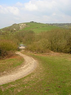
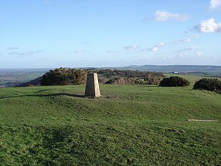
Rising from Under Hill Lane is Tenantry Down, which summits at Ditchling Beacon. At 813ft (248 metres), Ditchling Beacon (TQ 331 130) is the highest point on the eastern Downs. It was an Iron Age Fort and has a number of barrows.[11][12] There are three ancient bostals that ascend the slopes to Beacon, the central of which, Ditchling Bostal, is now the busy motor road. The bostals (two unnamed) pass some of the best remaining chalk grasslands in East Sussex and is an important area for wildlife including now rare plants, butterflies and moths.
One hundred metres or so to the west from the bottom of the main Ditchling Bostals is Burnhouse Bostal which reaches the top above Keymer Down. Along Burnhouse Bostal, the red listed birds of high conservation concern, spotted flycatcher, bred in 2021 indicating the importance of the SSSI.[16] Scavenging red kite are an increasingly common sight from the beacon too,
Westmeston Down
The Westmeston Down rises from Westmeston Farm. Two bostals, Westmeston and Middleton (TQ 343 130), meet at the top (TQ 338 130), between Western Brow and Home Brow. The two paths divide a large cluster of round barrows, (TQ 339 128), which are easier to make out on the western side than the eastern side.[17] In Spring, the Westmeston bostal is rich with wildflower and harbours a huge old ash pollard (TQ 340 130), which many seek out to admire. There are old limekilns in Westmeston chalk pit and the chalk pit south of The Gote, (TQ 348 132).[8] The slopes have well-formed terracettes, ridges, formed by centuries of grazing by sheep.
Streat Hill
Streat Hill viewed from the escarpment near Ditchling Cross. The track leading down the hill is Plumpton Bostal.
Streat Hill rises to 224m above sea level. There are two tumuli or bowl barrows, though they are scarcely visible. They have been termed by archaeologists the Western Brow round barrow cemetery.[18] Stanmer manor used Streat bostal for livestock movements between the Downs and its Wealden outliers. The bostal track is deep, steep and zig-zags.
The Streat Hill bostal and scarp slope (TQ 351 130) has long been ungrazed, and as a consequence has lost much of the species-rich chalk grassland to invasive scrub. Despite the biodiversity they bring, only islands of that very rich turf remain, usually on the bostal's deep cut sides.[8]
To the west of the Streat Hill is the Queen Victoria Jubilee plantation (TQ 348 130), which forms the sign of a V on the middle of the bare scarp slope. Six different tree species were planted in 1887 to mark Queen Victoria's Silver Jubilee.
Plumpton Hill
Plumpton Hill, The Coombe, South Downs
There are two bostals that run up the side of this section of the scarp, the Plumpton (TQ 360 128) and the Novington bostal (TQ 370 128). The Plumpton bostal rises from the Half Moon Inn. The field opposite the Half Moon was known as the Brighton Laine according to the Tithe map of 1839, perhaps because it marked the beginning of the Downland route to the town. The bostal was concreted in the Second World War to take vehicles to the training grounds on the plateau. It looks down over a stretch of scarp which is still owned by Brighton Council, though leased to Plumpton Agricultural College.[8] It has a good assemblage of Down pasture flowers and secondary woodland at the bottom is rich in species, such as bluebells and ramsons. Just to the east of the bostal is a 100-foot cross has been carved into the chalk, called Ditchling Cross, probably made by the monks of St Pancras Priory in Lewes. The cross is no longer white, but to the knowledgeable eye it is still visible due to its lighter-coloured grass and when the sun is low and the depression is in shadow it can be made out from several miles away.[19]
Novington Scarp
To the east is the Novington chalk pit (TQ 370 128) through which the Novington bostal runs. Above it, a wood was planted in the nineteenth century called The Beeches, which has now spread more widely.
At the top of Plumpton Hill and Novington Scarp there are three clusters of round barrows on this on each of the three main spurs that jut forward. They are low so they are not obvious although there is one on the arable just south of the South Downs Way and just west of Novington Plantation that is a yard tall (TQ 364 125).[20]
Unlike the rest of this SSSI, Ashcombe Bottom is a south facing woodland valley that is on the other side of the ridge from the rest of the escarpment at Blackcap. The area has many glades and rides with a chalk grassland flora and fauna. There are a good range of songbirds including bullfinch, song thrush and summer breeding warblers, including blackcap and garden warbler. There are deer present and dormouse boxes have been put up. Sheep have access to some parts of the wood.[1]
Coombe Plantation
Path into Coombe Plantation
The Coombe Plantation (TQ 386 122) is a relatively young wood, planted around 1800. Above south west corner of the woodland are the Blackcap and Mount Harry peaks. The plantation has a cool and lofty interior of tall ash, sycamore, surviving beech and occasional horse chestnut. The biggest trees are along the lower boundary, although many were blown down in the 1987 and 1992 gales, particularly at its eastern end. The fallen beech carcasses are home to many fungi including green stain, turkey tail, lemon disco, jelly rot, porcelain fungus and dryad's saddle. Collared earthstar is here amongst the leaf litter. The spring flowers are most plentiful at the base of slope. Elsewhere things like bluebells are scarce, although there are swarms of early purple orchids upslope. In the shadier parts, such as along the bostal, there are profuse growths of hart's tongue fern.
Offham Combe and Down
Offham Down, East Sussex, looking north towards Offham village and Hamsey
This is a special place, locally called "Happy Valley". The area has a long history. There is an evocative group of ten Saxon barrows on the short turfed, flatter ground of the spur, and further barrows up the hill but there are either destroyed or sunk in tangled scrub.[21] There is a peculiar and attractive two-track ancient bostal which rises up the valley side from Offham. It is thought that after marching from Fletching, the London troops under Simon De Montfort walked up this bostal on the dawn of the day of the Battle of Lewes. They will have risen to the spur, which Coombe Plantation now partly covers, and formed the left flank of the rebel army. Poorly armed and trained they were swept away back down the scarp by the royalist cavalry, before the cavalry over-reached themselves and De Montfort's other troops battled down into Lewes and victory.[22]
There used to be purple heather on the crown of Offham Hill for which it gained it the nickname ‘Little Scotland’ in Victorian times.[8] It is secondary woodland, now. However, things could have gone worse for the biodiversity of the area. Although it is part of an SSSI, in 1997 the farmer wished to plough much of the tractor accessible ground to grow flax, which was then attracting hefty European Union subsidies even on such protected sites. English Nature did not to use their powers and the farmer commenced ploughing.[23] Nature conservationists attempted to block the plough, but the farmer returned at night. The struggle then escalated and conservationists demonstrated, set up camp on the land and started to organize its ‘unploughing’ by turning over and refitting the sods. Local people also turned out in force. Luckily the battle took place during the general election, so the Conservatives and Labour competed to show their conservation mettle and the special downland scarp was saved.[8]
Related Research Articles
Brighton and Hove is a city and unitary authority in East Sussex, England. It consists primarily of the settlements of Brighton and Hove, alongside neighbouring villages.
Falmer is a small village and civil parish in the Lewes District of East Sussex, England, lying between Brighton and Lewes, approximately five miles (8 km) north-east of the former. It is also the site of Brighton & Hove Albion's Falmer Stadium.
Ditchling is a village and civil parish in the Lewes District of East Sussex, England. The village is contained within the boundaries of the South Downs National Park; the order confirming the establishment of the park was signed in Ditchling.
Hassocks is a large village and civil parish in the Mid Sussex District of West Sussex, England. Its name is believed to derive from the tufts of grass found in the surrounding fields.
East Chiltington is a village and civil parish in the Lewes District of East Sussex, England. It is centred four miles (5.9 km) south-east of Burgess Hill and five miles (8 km) north-west of Lewes. It is a strip parish of 3.76 square miles (9.7 km2), stretching northward from the crest of the South Downs. The village church is 13th century in origin; the vicar also has charge of two churches in Plumpton. Near the church there is a pub called The Jolly Sportsman. The Sussex Greensand Way, a Roman road, runs from east to west through the centre of the parish.
Hamsey is a civil parish in the Lewes District of East Sussex, England. The parish covers a large area and consists of the villages of Hamsey, Offham and Cooksbridge. The main centres of population in the parish are now Offham and Cooksbridge. Around the main settlements are enlarged fields, isolated old cottages and farms. The winding and undulating parish lanes between banks, old hedge rows, trees, flowery verges and ditches are rightly popular with cyclists and give good views of the Downs.
Iford is a village and civil parish in the Lewes District of East Sussex, England. The village is located two miles (3.2 km) south of Lewes. The parish lies on slopes of the South Downs in the valley of the River Ouse.
Kingston near Lewes is a village and civil parish in the Lewes District of East Sussex, England. The village is mentioned in the Domesday Book and is located two miles (3.2 km) south of Lewes and is nestled in the South Downs. The parish is par of two Sites of Special Scientific Interest: the Lewes Brooks and Kingston Escarpment and Iford Hill.
Plumpton is a village and civil parish in the Lewes District of East Sussex, England. The village is located five miles (8 km) north-west of Lewes. The parish measures 6.5 miles in length on its north–south axis and 1 mile at its widest on the B2116 Underhill Road. The southern half of the parish lies within the South Downs National Park and at the highest point, 214m (702 feet), the South Downs Way traverses the crest of Plumpton Plain. The parish includes the small village of Plumpton adjacent to the Downs and to the north the larger village of Plumpton Green where most of the community and services are based. Plumpton is known for its race course, and also Plumpton College, which farms over 2500 acres of land and has become one of the leading centres for land-based education in the UK.
St Ann Without is a civil parish in the Lewes District of East Sussex, England. It covers an area to the west of the town of Lewes, including Long Hill.
St John Without is a small civil parish in the Lewes District of East Sussex, England, covering an area to the north-west of the town of Lewes.
Westmeston is a village and civil parish in the Lewes District of East Sussex, England heavily dependent in amenities on larger Ditchling to the near-immediate northwest. It is four miles (6 km) south-southeast of Burgess Hill and (10 km) west of Lewes, on the northern slopes of the South Downs.
Streat is a village and parish in the Lewes district of East Sussex, England, 3 miles (4.8 km) south-east of Burgess Hill and 5 miles (8.0 km) west of Lewes, within the South Downs National Park.
Fulking is a village and civil parish in the Mid Sussex District of West Sussex, England. The parish lies wholly with the South Downs National Park.
Newtimber is a small village and civil parish in the Mid Sussex District of West Sussex, England. It is located north-west of Brighton. The parish also includes the hamlet of Saddlescombe. The parish lies almost wholly with the South Downs National Park, with the exception of a small section of the parish north of the B2117 road. The planning authority for Newtimber is therefore the South Downs National Park Authority (SDNPA), the statutory planning authority for the National Park area. The downland scarp, which includes Newtimber Hill, Newtimber Holt, Saddlescombe chalk quarry and Summer Down, is mostly part of the Beeding Hill to Newtimber Hill, designated Site of Special Scientific Interest.
Ditchling Beacon is the highest point in East Sussex, England, with an elevation of 248 m (814 ft). It is south of Ditchling and to the north-east of Brighton. It is a large chalk hill with a particularly steep northern face, covered with open grassland and sheep-grazing areas. It is the third-highest point on the South Downs, behind Butser Hill and Crown Tegleaze.
Clayton is a small village at the foot of the South Downs in the parish of Hassocks, West Sussex, England. It lies 41 miles (66 km) south of London, 6 miles (10 km) north of Brighton, and 28 miles (45 km) east northeast of the county town of Chichester. Other nearby towns include Burgess Hill to the north and Lewes, the county town of East Sussex east southeast. The Clayton Windmills, known as "Jack and Jill" sit on the hill above the village.
Blackcap is a hill and nature reserve in East Sussex, England. It is on a peak of the South Downs, just south east of Plumpton and west of Lewes. The flatter landscape is made up of open ground with chalk paths, surrounded by thickets. The steeper ground leading up to the ridge is low-density woodland. The top is more open, with patches of pine woodland and gorse bushes.
Beeding Hill to Newtimber Hill is a 321-hectare (790-acre) biological and geological Downland Site of Special Scientific Interest (SSSI) north of Shoreham-by-Sea in West Sussex. It is a Nature Conservation Review site, Grade 2, and it includes Devil's Dyke Geological Conservation Review site.
Ashcombe Bottom is a 66 hectare woodland valley owned by the National Trust that runs south from Blackcap, East Sussex, England. The area is nested in the South Downs and can only be reached by walking or cycling from Lewes, Falmer, Ditchling Beacon or up the Clayton to Offham escarpment from Plumpton. It sits in the parish of St John Without and East Chiltington. The name Ashcombe refers to a Saxon named Aecci, not ash trees as might be assumed. It is part of the Clayton to Offham Escarpment Site of Special Scientific Interest.
This page is based on this Wikipedia article Text is available under the CC BY-SA 4.0 license; additional terms may apply. Images, videos and audio are available under their respective licenses.