Scaynes Hill is a village in the civil parish of Lindfield Rural in the Mid Sussex District of West Sussex, England. It lies on the A272 road 2.2 miles (3.5 km) east of Haywards Heath.

Netherside Stream Outcrops is a 2.9-hectare (7.2-acre) geological Site of Special Scientific Interest north-east of Haslemere in Surrey. It is a Geological Conservation Review site.

Stockstone Quarry is a 3.9-hectare (9.6-acre) geological Site of Special Scientific Interest south of Farnham in Surrey. It is a Geological Conservation Review site.
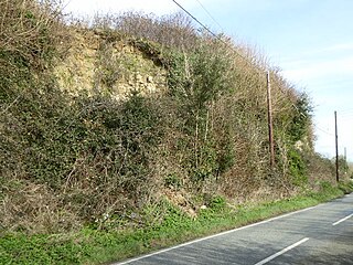
Houghton Green Cliff is a 0.14-hectare (0.35-acre) geological Site of Special Scientific Interest north of Rye in East Sussex, United Kingdom. It is a Geological Conservation Review site.

Lower Dicker is a 0.1-hectare (0.25-acre) geological Site of Special Scientific Interest west of Hailsham in East Sussex. It is a Geological Conservation Review site.

Hastingford Cutting is a 0.04-hectare (0.099-acre) geological Site of Special Scientific Interest south of Crowborough in East Sussex. It is a Geological Conservation Review site.

Waldron Cutting is a 0.2-hectare (0.49-acre) geological Site of Special Scientific Interest in East Sussex. It is a Geological Conservation Review site.

Northiam SSSI is a 0.3-hectare (0.74-acre) geological Site of Special Scientific Interest in Northiam in East Sussex. It is a Geological Conservation Review site.

Turners Hill SSSI is a 0.2-hectare (0.49-acre) geological Site of Special Scientific Interest in Turners Hill in West Sussex. It is a Geological Conservation Review site.

Stone Farm Rocks or Stone Hill Rocks is a 0.6-hectare (1.5-acre) geological Site of Special Scientific Interest south of East Grinstead in West Sussex. It is a Geological Conservation Review site.
Muswell Hill is a 0.2-hectare (0.49-acre) geological Site of Special Scientific Interest north-west of Brill in Buckinghamshire. The local planning authorities are Buckinghamshire County Council and Aylesbury Vale District Council. It is listed by the Joint Nature Conservation Committee as a Geological Conservation Review site.

Bognor Reef is a 39.7-hectare (98-acre) biological and geological Site of Special Scientific Interest which stretches along the foreshore of Bognor Regis in West Sussex. It is a Geological Conservation Review site.

Chantry Mill is a 8.7-hectare (21-acre) geological Site of Special Scientific Interest in Storrington in West Sussex. It is a Geological Conservation Review site.
Park Farm Cutting is a 0.2-hectare (0.49-acre) geological Site of Special Scientific Interest west of Pulborough in West Sussex. It is a Geological Conservation Review site.

Philpot's and Hook Quarries is a 2.6-hectare (6.4-acre) geological Site of Special Scientific Interest south-west of Sharpthorne in West Sussex. It is a Geological Conservation Review site.

Wakehurst and Chiddingly Woods is a 155.9-hectare (385-acre) biological and geological Site of Special Scientific Interest south-east of Crawley in West Sussex, England. It is a Nature Conservation Review site, Grade I, and part of it is a Geological Conservation Review site.

Sharp's Hill Quarry is a 2.4-hectare (5.9-acre) geological Site of Special Scientific Interest west of Banbury in Oxfordshire. It is a Geological Conservation Review site.
