
Netherside Stream Outcrops is a 2.9-hectare (7.2-acre) geological Site of Special Scientific Interest north-east of Haslemere in Surrey. It is a Geological Conservation Review site.
Houghton Green Cliff is a 0.14-hectare (0.35-acre) geological Site of Special Scientific Interest north of Rye in East Sussex. It is a Geological Conservation Review site.

Lower Dicker is a 0.1-hectare (0.25-acre) geological Site of Special Scientific Interest west of Hailsham in East Sussex. It is a Geological Conservation Review site.

River Line SSSI is a 2.2-hectare (5.4-acre) geological Site of Special Scientific Interest south of Robertsbridge in East Sussex. It is a Geological Conservation Review site.

Waldron Cutting is a 0.2-hectare (0.49-acre) geological Site of Special Scientific Interest in East Sussex. It is a Geological Conservation Review site.

Blackhorse Quarry is a 0.2-hectare (0.49-acre) geological Site of Special Scientific Interest south-east of Battle in East Sussex. It is a Geological Conservation Review site.

Brede Pit and Cutting is a 0.6-hectare (1.5-acre) geological Site of Special Scientific Interest in Brede in East Sussex. It is a Geological Conservation Review site.

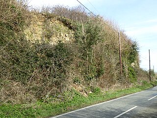
Winchelsea Cutting is a 0.15-hectare (0.37-acre) geological Site of Special Scientific Interest on the southern outskirts of Winchelsea in East Sussex. It is a Geological Conservation Review site.

Turners Hill SSSI is a 0.2-hectare (0.49-acre) geological Site of Special Scientific Interest in Turners Hill in West Sussex. It is a Geological Conservation Review site.

West Hoathly SSSI is a 0.7-hectare (1.7-acre) geological Site of Special Scientific Interest in Sharpthorne in West Sussex. It is a Geological Conservation Review site.

The Ashdown Formation is a geological unit, which forms part of the Wealden Group and the lowermost and oldest part of the now unofficial Hastings Beds. These geological units make up the core of the Weald in the English counties of East Sussex and Kent.
Stone SSSI is a 0.12 hectare geological Site of Special Scientific Interest in Stone in Buckinghamshire. It is listed by the Joint Nature Conservation Committee as a Geological Conservation Review site.

Cranford St John SSSI is a 2.8 hectare geological Site of Special Scientific Interest in Cranford St John, east of Kettering in Northamptonshire. It is a Geological Conservation Review site.

Scaynes Hill is a 0.04-hectare (0.099-acre) geological Site of Special Scientific Interest north-west of Newick in East Sussex. It is a Geological Conservation Review site.
Coppedhall Hanger is a 0.6-hectare (1.5-acre) geological Site of Special Scientific Interest north of Billingshurst in West Sussex. It is a Geological Conservation Review site.

Warnham SSSI is a 28.5-hectare (70-acre) geological Site of Special Scientific Interest north of Horsham in West Sussex. It is a Geological Conservation Review site.

Freshfield Lane is a 17-hectare (42-acre) geological Site of Special Scientific Interest east of Haywards Heath in West Sussex. It is a Geological Conservation Review site.

Philpot's and Hook Quarries is a 2.6-hectare (6.4-acre) geological Site of Special Scientific Interest south-west of Sharpthorne in West Sussex. It is a Geological Conservation Review site.
