Kent is the south-easternmost county in England. It is bounded on the north by the River Thames and the North Sea, and on the south by the Straits of Dover and the English Channel. The continent of Europe is 21 miles across the straits.

Netherside Stream Outcrops is a 2.9-hectare (7.2-acre) geological Site of Special Scientific Interest north-east of Haslemere in Surrey. It is a Geological Conservation Review site.

High Rocks is a 3.2-hectare (7.9-acre) geological Site of Special Scientific Interest west of Tunbridge Wells in East Sussex and Kent. It is a Geological Conservation Review site.
Houghton Green Cliff is a 0.14-hectare (0.35-acre) geological Site of Special Scientific Interest north of Rye in East Sussex. It is a Geological Conservation Review site.
Brighton to Newhaven Cliffs is a 165.4-hectare (409-acre) biological and geological Site of Special Scientific Interest and Geological Conservation Review site, which stretches along the coast between Brighton and Newhaven in East Sussex. An area of 16.4 hectares is the Castle Hill, Newhaven Local Nature Reserve
Dungeness, Romney Marsh and Rye Bay is a 10,172.9-hectare (25,138-acre) biological and geological Site of Special Scientific Interest which stretches from New Romney in Kent to Winchelsea in East Sussex. An area of 5,129.5 hectares is a Special Protection Area, an area of 3,141.1 hectares is a Special Area of Conservation, and an area of 6,377.6 hectares is a Ramsar Site, a wetland site designated of international importance under the Ramsar Convention. Part of the site is in the High Weald Area of Outstanding Natural Beauty, parts are Geological Conservation Review sites, part is a Local Nature Reserve, and part is a Royal Society for the Protection of Birds nature reserve, and part is a National Nature Reserve.

Winchelsea Cutting is a 0.15-hectare (0.37-acre) geological Site of Special Scientific Interest on the southern outskirts of Winchelsea in East Sussex. It is a Geological Conservation Review site.

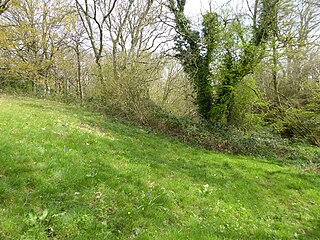
Northiam SSSI is a 0.3-hectare (0.74-acre) geological Site of Special Scientific Interest in Northiam in East Sussex. It is a Geological Conservation Review site.

Turners Hill SSSI is a 0.2-hectare (0.49-acre) geological Site of Special Scientific Interest in Turners Hill in West Sussex. It is a Geological Conservation Review site.

Stone Farm Rocks or Stone Hill Rocks is a 0.6-hectare (1.5-acre) geological Site of Special Scientific Interest south of East Grinstead in West Sussex. It is a Geological Conservation Review site.

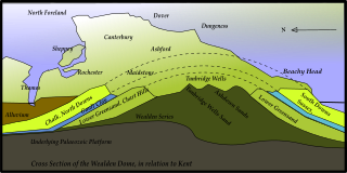
The Ashdown Formation is a geological unit, which forms part of the Wealden Group and the lowermost and oldest part of the now unofficial Hastings Beds. These geological units make up the core of the Weald in the English counties of East Sussex and Kent.
The geology of Kent in southeast England largely consists of a succession of northward dipping late Mesozoic and Cenozoic sedimentary rocks overlain by a suite of unconsolidated deposits of more recent origin.
The geology of West Sussex in southeast England comprises a succession of sedimentary rocks of Cretaceous age overlain in the south by sediments of Palaeogene age. The sequence of strata from both periods consists of a variety of sandstones, mudstones, siltstones and limestones. These sediments were deposited within the Hampshire and Weald basins. Erosion subsequent to large scale but gentle folding associated with the Alpine Orogeny has resulted in the present outcrop pattern across the county, dominated by the north facing chalk scarp of the South Downs. The bedrock is overlain by a suite of Quaternary deposits of varied origin. Parts of both the bedrock and these superficial deposits have been worked for a variety of minerals for use in construction, industry and agriculture.

Scaynes Hill is a 0.04-hectare (0.099-acre) geological Site of Special Scientific Interest north-west of Newick in East Sussex. It is a Geological Conservation Review site.

Coneyhurst Cutting is a 0.2-hectare (0.49-acre) geological Site of Special Scientific Interest south-east of Billingshurst in West Sussex. It is a Geological Conservation Review site.
Coppedhall Hanger is a 0.6-hectare (1.5-acre) geological Site of Special Scientific Interest north of Billingshurst in West Sussex. It is a Geological Conservation Review site.

Slinfold Stream and Quarry is a 2.3-hectare (5.7-acre) geological Site of Special Scientific Interest west of Horsham in West Sussex. It is a Geological Conservation Review site.

Warnham SSSI is a 28.5-hectare (70-acre) geological Site of Special Scientific Interest north of Horsham in West Sussex. It is a Geological Conservation Review site.

Philpot's and Hook Quarries is a 2.6-hectare (6.4-acre) geological Site of Special Scientific Interest south-west of Sharpthorne in West Sussex. It is a Geological Conservation Review site.

Perry Copse Outcrop is a 0.2-hectare (0.49-acre) geological Site of Special Scientific Interest in Fernhurst in West Sussex. It is a Geological Conservation Review site.
