M, or m, is the thirteenth letter of the Latin alphabet, used in the modern English alphabet, the alphabets of other western European languages and others worldwide. Its name in English is em, plural ems.

Manoj Nelliyattu "M. Night" Shyamalan is an American film director, producer and screenwriter. His films often employ supernatural plots and twist endings. The cumulative gross of his films exceeds $3.3 billion globally. Shyamalan has received various accolades, including nominations for two Academy Awards, two BAFTA Awards and a Golden Globe.
The higher region of the Alps were long left to the exclusive attention of the inhabitants of the adjoining valleys, even when Alpine travellers began to visit these valleys. It is reckoned that about 20 glacier passes were certainly known before 1600, about 25 more before 1700, and yet another 20 before 1800. Even though the attempt of P.A. Arnod, an official of the duchy of Aosta, in 1689 to "re-open" the Col du Ceant may be counted as having been made by a non-native, historical records do not show any further such activities until the last quarter of the 18th century. Nor did it fare much better with the high peaks, though the two earliest recorded ascents were due to non-natives, that of the Rocciamelone in 1358 having been undertaken in fulfilment of a vow, and that of the Mont Aiguille in 1492 by order of Charles VIII of France, in order to destroy its immense reputation for inaccessibility – in 1555 Conrad Gesner did not climb Pilatus proper, but only the grassy mound of the Gnepfstein, the lowest and the most westerly of the seven summits.

Monte Rosa is a mountain massif in the eastern part of the Pennine Alps, on the border between Italy and Switzerland (Valais). The highest peak of the massif, amongst several peaks of over 4.000 m, is the Dufourspitze, the second highest mountain in the Alps and western Europe, after Mont Blanc. The east face of the Monte Rosa towards Italy has a height of about 2.400 meters and is the highest mountain wall of the Alps.

The Dom is a mountain of the Pennine Alps, located between Randa and Saas-Fee in the canton of Valais in Switzerland. With a height of 4,546 m (14,915 ft), it is the seventh highest summit in the Alps, overall. Based on prominence, it can be regarded as the third highest mountain in the Alps, and the second highest in Switzerland, after Monte Rosa. The Dom is the main summit of the Mischabel group, which is the highest massif lying entirely in Switzerland.

Lucy Walker was a British mountaineer and the first woman to climb the Matterhorn.

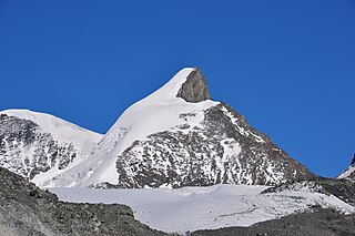
The Strahlhorn is a mountain of the Swiss Pennine Alps, located south of Saas-Fee and east of Zermatt in the canton of Valais. It lies on the range that separates the Mattertal from the Saastal and is located approximately halfway between the Rimpfischhorn and the Schwarzberghorn.
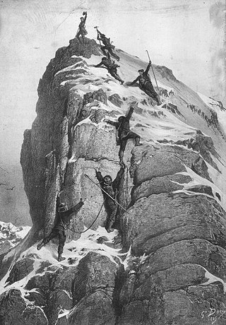
The golden age of alpinism was the decade in mountaineering between Alfred Wills's ascent of the Wetterhorn in 1854 and Edward Whymper's ascent of the Matterhorn in 1865, during which many major peaks in the Alps saw their first ascents.

Mattmark dam is a reservoir in the Saas Valley of the Canton of Valais, Switzerland. The Mattmark dam was built from 1960 to 1965. The lake's surface area is 1.76 km2 (0.68 sq mi).
The bibcode is a compact identifier used by several astronomical data systems to uniquely specify literature references.

The Findel Glacier is a valley glacier in the Monte Rosa massif east of Zermatt in the Pennine Alps. It has a length of 8 km (5.0 mi) and covers an area of 19 km2 (7.3 sq mi).

The Strahlhorn (3,027 m) is a mountain of the Bernese Alps, overlooking the Aletsch Glacier in the canton of Valais. It lies at the southern end of the Gross Wannenhorn range, just north of the Märjelensee.

The Schwarzberghorn is a mountain of the Pennine Alps, located on the border between Switzerland and Italy. Its summit is the tripoint between the valleys Mattertal, Saastal and Valle Anzasca and the southernmost point of the Mischabel-Strahlhorn chain, and northern end of the Weissgrat.
The Adlerhorn is a mountain of the Swiss Pennine Alps, located east of Zermatt in the canton of Valais. It lies west of the Strahlhorn.
The Allalin Glacier is a 6 km (3.7 mi) long glacier (2005) situated in the Pennine Alps near the Allalinhorn in the canton of Valais in Switzerland. In 1973 it had an area of 9.9 km2 (3.8 sq mi). The glacier is bordered on the west by the Allalinhorn, Rimpfischhorn and Strahlhorn. It is not to be confused with the Fee Glacier which lies on the northern flank of Allalinhorn.

The Fluchthorn is a mountain of the Swiss Pennine Alps, located south of Saas-Almagell in the canton of Valais. It lies east of the Strahlhorn.

The Britannia Hut is a mountain hut of the Swiss Alpine Club, located south of Saas-Almagell in the canton of Valais. It is situated 3,030 metres above sea level, at the foot of the Allalinhorn near the Allalin Glacier, in the Mischabel massif. It is a starting point for the ascents of Strahlhorn, Rimpfischhorn and Allalinhorn.
The Strahlhorn is a mountain of the Pennine Alps, east of Zermatt and south of Saas Fee in Valais. It is also the name of several other mountains in Switzerland:

Thomas Middlemore was an English mountaineer who made multiple first ascents during the silver age of alpinism. His audacity earned him a reputation as the enfant terrible within the Alpine Club. He was also the head of the Middlemores Saddles leather goods company in Birmingham, England, after the retirement of his father, William Middlemore, in 1881. Thomas Middlemore had taken over the management of the company in 1868 and established a bicycle saddle factory in Coventry.

The Vordersee is a reservoir located east of the Aletsch Glacier, between the Strahlhorn and the Eggishorn, in the Swiss canton of Valais. The lake has a surface area of 0.062 km² and is located at 2,360 metres above sea level. It is located in the municipality of Fieschertal.
