Stupava, Malacky District

Last updated
Stupava
Town
Stupava, kostol, Slovensko.jpg
Church of Saint Stephen
Coat of Arms of Stupava.svg
Coat of arms
Bratislava Region - physical map.png
Red pog.svg
Stupava
Location of Stupava in the Bratislava Region
Relief Map of Slovakia 2.png
Red pog.svg
Stupava
Stupava (Slovakia)
Coordinates: 48°16′16″N17°01′54″E / 48.27111°N 17.03167°E / 48.27111; 17.03167 Coordinates: 48°16′16″N17°01′54″E / 48.27111°N 17.03167°E / 48.27111; 17.03167
CountrySlovakia
Region Bratislava
District Malacky
First mentioned1269
Government
  MayorPeter Novisedlák
Area
  Total67.178 km2 (25.938 sq mi)
Elevation
182 m (597 ft)
Population
 (2018-12-31 [1] )
  Total11,887
  Density180/km2 (460/sq mi)
Time zone UTC+1 (CET)
  Summer (DST) UTC+2 (CEST)
Postal code
900 31
Area code(s) +421-2
Car plate MA
Website www.stupava.sk

Stupava (German : Stampfen; Hungarian : Stomfa) is a town in western Slovakia. It is situated in the Malacky District, Bratislava Region.

Contents

Etymology

The name is derived from Proto-Slavic stǫpa (Slovak : stupa) - a wooden bowl carved from a tree trunk, but also the name of various crushing and pressing tools. [2]

Geography

The town is located in the Záhorie lowland, under the Little Carpathians, around 15 km (9 mi) north of Bratislava at an altitude of 182 metres. It has 13, 499 inhabitants as of 2015 and has a land area of 67.17 km2 (26 sq mi). Apart from the core part of the city, Mást (German : Maaßt, Hungarian : Mászt), located just south of the core part of the city, is another part of Stupava. It has been initially a separate village with ethnic Croatian majority, which was formally annexed by Stupava in 1953. [3]

History

However, traces of habitation go back to the Bronze Age, and the first known inhabitants were the Celts. The Romans built a military station as a part of the near Limes Romanus on the Danube. The first written mention about the town was in 1269 in a document of the King Béla IV under name Ztumpa. In the second half of the 13th century the now-ruined Pajštún Castle in the Little Carpathians was built. It was developing mainly as an agricultural and trading settlement. The name of the town comes from the pressing mills called stupa on the Stupavský potok brook, which were used for extracting oil from flax and hemp.

Landmarks

Demographics

According to the 2001 census, the town had 8,063 inhabitants. 96.7% of inhabitants were Slovaks, 1% Czechs and 0.5% Hungarians. [4] The religious makeup was 70.4% Roman Catholics, 19.5% people with no religious affiliation and 2% Lutherans. [4]

Twin towns — sister cities

Stupava is twinned with: [5]

Related Research Articles

Trenčín City in Slovakia

Trenčín is a city in western Slovakia of the central Váh River valley near the Czech border, around 120 km (75 mi) from Bratislava. It has a population of more than 55,000, which makes it the eighth largest municipality of the country and is the seat of the Trenčín Region and the Trenčín District. It has a medieval castle, Trenčín Castle, on a rock above the city.

Galanta Town in Slovakia

Galanta is a town in the Trnava Region of Slovakia. It is situated 50 km due east of the Slovak capital Bratislava.

Bytča Town in Slovakia

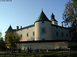
Bytča is a town in northwestern Slovakia. It is located on the Váh River near the cities of Žilina and Považská Bystrica. It belongs to Upper Váh region of tourism.

Pezinok Town in Slovakia

Pezinok is a town in southwestern Slovakia. It is roughly 20 km (12.43 mi) northeast of Bratislava and, as of December 2018, had a population of 23,002.

Ilava Town in Slovakia

Ilava is a town in the Trenčín Region, northwestern Slovakia.

Hlohovec Town in Slovakia

Hlohovec (German: Freistad an der Waag, Hungarian Galgóc, is a town in southwestern Slovakia, with a population of 21,508.

Michalovce Town in Slovakia

Michalovce is a town on the Laborec river in eastern Slovakia. Originally named after the Archangel St Michael, it is the second-largest city in the Košice Region and the seat of the Michalovce District.

Kremnica Town in Slovakia

Kremnica is a town in central Slovakia. It has around 5,300 inhabitants. The well-preserved medieval town built above important gold mines is the site of the oldest still-working mint in the world.

Dubnica nad Váhom Town in Slovakia

Dubnica nad Váhom is a town in the Ilava District, Trenčín Region in Slovakia.

Modra Town in Slovakia

Modra is a city and municipality in the Bratislava Region in Slovakia. It has a population of 9,042 as of 2018. It nestles in the foothills of the Malé Karpaty and is an excellent centre of hiking.

Nové Mesto nad Váhom Town in Slovakia

Nové Mesto nad Váhom is a town in the Trenčín Region of Slovakia.

Gelnica Town in Slovakia

Gelnica is a town in the Košice Region of Eastern Slovakia. It has a population of 6,076.

Svätý Jur Town in Slovakia

Svätý Jur is a small historical town northeast of Bratislava, located in the Bratislava Region. The city is situated on the slopes of Little Carpathians mountains and surrounded by typical terraced vineyards with more than 700 years of winemaking tradition. In 1990, the intact city center was declared a protected city reservation. Cadastrially, Svätý Jur includes also the natural reserve Šúr, established in 1952 to protect one of the last and largest remnants of a tall-stem swamp alder forest in Central Europe.

Sereď Town in Slovakia

Sereď is a town in southern Slovak Republic near Trnava, on the right bank of the Váh River on the Danubian Lowland. It has approximately 15,500 inhabitants.

Senica Town in Slovakia

Senica is a town in Trnava Region, western Slovakia. It is located in the north-eastern part of the Záhorie lowland, close to the Little Carpathians.

Myjava Town in Slovakia

Myjava is a town in Trenčín Region, Slovakia.

Veľký Šariš Town in Slovakia

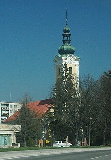
Veľký Šariš is a small town near Prešov in eastern Slovakia. The town is known as the site of the largest brewery in Slovakia – Šariš Brewery.

Modrý Kameň Town in Slovakia

Modrý Kameň is a town and municipality in the Veľký Krtíš District of the Banská Bystrica Region of southern Slovakia.

Holíč Town in Slovakia

Holíč is a town in western Slovakia.

Stará Turá Town in Slovakia

Stará Turá is a town in the Trenčín Region in western Slovakia.

References

  1. "Population and migration". Statistical Office of the Slovak Republic. Retrieved 2019-04-16.
  2. Závodný, Andrej (2010). "Vodné názvy slovenskej časti Pomoravia". VARIA XVII (PDF) (in Slovak). Ružomberok: Katolícka univerzita v Ružomberku – Filozofická fakulta, Slovenská jazykovedná spoločnosť pri SAV. p. 778. ISBN   978-80-8084-550-6.
  3. "Trocha z histórie Mástu". Mástsky potravinový spolok v Stupave. Retrieved 2019-06-25.
  4. 1 2 "Municipal Statistics". Statistical Office of the Slovak republic. Archived from the original on 2007-10-27. Retrieved 2007-11-06.
  5. "Úvodná strana". stupava.sk (in Slovak). Stupava. Retrieved 2019-09-04.

Commons-logo.svg Media related to Stupava at Wikimedia Commons