Related Research Articles

Sugar Grove is an unincorporated community located in Watauga County, North Carolina, United States. It is named after the sugar maples that grow in the area. The community is located along US 321, west of Vilas and Boone, along the banks of Cove Creek.
Sugar Grove Station is a National Security Agency (NSA) communications site located near Sugar Grove in Pendleton County, West Virginia. According to a 2005 article in the New York Times, the site intercepts all international communications entering the Eastern United States. Activities at the site previously involved the Naval Information Operations Command (NAVIOCOM). In April 2013, the Chief of Naval Operations ordered that the NAVIOCOM base be closed by September 30, 2015, as "a result of the determination by the resource sponsor National Security Agency to relocate the command's mission." The naval base is being repurposed as a privately owned healthcare facility for veterans, while the NSA listening station, to the south, continues to operate.

Buildings, sites, districts, and objects in Virginia listed on the National Register of Historic Places:

Institute is an unincorporated community on the Kanawha River in Kanawha County, West Virginia, United States. Interstate 64 and West Virginia Route 25 pass by the community, which has grown to intermingle with nearby Dunbar. Institute is home to West Virginia State University and the West Virginia State Police Academy. In August 2008 a chemical plant explosion here killed two and injured eight at the Bayer CropScience facility.

Algoma is an unincorporated community in McDowell County, West Virginia, United States. Algoma is located adjacent to the town of Northfork. Its post office was established in 1891 and discontinued in 1988. Algoma most likely was derived from the Algonquin language.
Oak Grove is an unincorporated community in northern Surry County, North Carolina near Bottom.
Greenville is an unincorporated community in Monroe County, West Virginia, United States. Greenville is located on West Virginia Route 122 west of Union. The community was formerly called Centreville.
Madison Mills is an unincorporated community located in Madison County, Virginia, United States.
London is an unincorporated community in Kanawha County in the U.S. state of West Virginia, located 25 miles from the state capital of Charleston. London Lock and Dam, operated by US Army Corps of Engineers is located here on Kanawha River.

This is a list of the National Register of Historic Places listings in Caroline County, Virginia.

Southside is an unincorporated community in Mason County, West Virginia, United States. Southside is located near the Kanawha River south of Leon. It is currently served by U.S. Route 35, but will be bypassed once the planned upgrading of that route into a four-lane highway is complete.
Landisburg is an unincorporated community in Fayette County, West Virginia, United States. Landisburg is located along West Virginia Route 41 11 miles (18 km) east of Oak Hill.

Atkins Park is an intown neighborhood of Atlanta, Georgia, nestled against the southeast corner of the neighborhood of Virginia-Highland, west of Briarcliff Avenue and north of Ponce de Leon Avenue ("Ponce"). It consists of just three streets - St. Louis Place, St. Charles Place, and St. Augustine Place - as well as an internal sidewalk known as Malcolm's Way that bisects them from St. Charles to St. Louis. It was originally designed to give quicker access to the streetcar stop at Ponce.
Quiet Dell is an unincorporated community in Harrison County, West Virginia, USA. Quiet Dell is located at the junction of Interstate 79 and West Virginia Route 20 5 miles (8.0 km) southeast of Clarksburg.
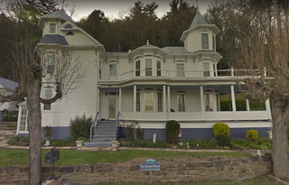
Bowers House is a historic home located at Sugar Grove, Pendleton County, West Virginia. It was built in 1898, and is a large, 2 1/2-story Queen Anne style frame dwelling. It features two asymmetrical polygonal towers, contrasting wood siding in a herringbone pattern, projecting gables and bays, and large brackets with contrasting color schemes.

Gum Spring is an unincorporated community in Louisa County, Virginia, United States. Gum Spring is located at the intersection of U.S. Route 250 and U.S. Route 522 18 miles (29 km) south-southeast of Louisa. Gum Spring has a post office with ZIP code 23065.

Spring Grove is an unincorporated community in Surry County, Virginia, United States. Spring Grove is located at the junction of Virginia State Route 10 and Virginia State Route 40 7.9 miles (12.7 km) west-northwest of Surry. Spring Grove has a post office with ZIP code 23881.
Harmony Grove is an unincorporated community in Monongalia County, West Virginia.
Cranesville is an unincorporated community in Preston County, West Virginia, United States. Cranesville is located along County Route 47 7.9 miles (12.7 km) north-northeast of Terra Alta.
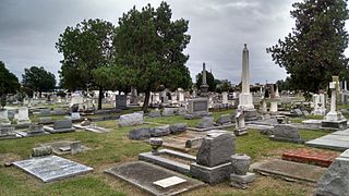
Cedar Grove Cemetery is a historic public cemetery located at Portsmouth, Virginia. It was established by an act of the Virginia General Assembly in 1832. The cemetery contains more than 400 graves with monuments dating from the late 1700s to the present. Its memorial markers include small tablets, ledger stones, obelisks, columnar monuments and mausoleums. They include notable examples of Greek Revival, Late Victorian, and Exotic Revival funerary art.
References
- ↑ U.S. Geological Survey Geographic Names Information System: Sugar Grove, West Virginia
- ↑ Kenny, Hamill (1945). West Virginia Place Names: Their Origin and Meaning, Including the Nomenclature of the Streams and Mountains. Piedmont, WV: The Place Name Press. pp. 609–610.
- ↑ "National Register Information System". National Register of Historic Places . National Park Service. July 9, 2010.
- ↑ Steelhammer, Rick (February 7, 2017). "Investment firm sheds light on plans for old Sugar Grove Navy base". Charleston Gazette. Retrieved 28 July 2017.
Municipalities and communities of Pendleton County, West Virginia, United States | ||
|---|---|---|
| Town |  | |
| CDP | ||
| Unincorporated communities | ||
| Ghost towns | ||
| This article about a location in Pendleton County, West Virginia is a stub. You can help Wikipedia by expanding it. |