
Año Nuevo Island is a small island off Año Nuevo Point on the coast of Northern California, between San Francisco and Santa Cruz. The island has an area of 9 acres (3.6 ha). It is an important breeding site for northern elephant seals and the endangered Steller's sea lion, as well as several species of seabirds, including rhinoceros auklets, Brandt's cormorants and western gulls. Due to the number of seals and sea lions, great white sharks are frequently spotted patrolling the waters around the island. It is protected as part of the Año Nuevo State Reserve.

Cape Mendocino, which is located approximately 200 miles (320 km) north of San Francisco, is located on the Lost Coast entirely within Humboldt County, California, United States. At 124° 24' 34" W longitude, it is the westernmost point on the coast of California. The South Cape Mendocino State Marine Reserve and Sugarloaf Island are immediately offshore, although closed to public access due to their protected status. Sugarloaf Island is cited as California's westernmost island.
A sugarloaf is refined sugar in the form of a rounded cone, the most common way of distributing sugar until the late 19th century.

Año Nuevo State Marine Conservation Area (SMCA) is one of two adjoining marine protected areas off the coast of San Mateo and Santa Cruz Counties, on California’s central coast. The area is approximately 55 miles south of San Francisco. The SMCA is 11.07 square miles. Except for limited taking of giant kelp, all living marine resources are protected.

The Sugar Loaf Islands are a collection of five small uninhabited islands and several sea stacks near Port Taranaki, Taranaki, New Zealand.
Sea Lion Cove State Marine Conservation Area (SMCA) is a marine protected area that lies onshore, just south of Point Arena in Mendocino County on California’s north central coast. The marine protected area covers 0.22 square miles. Sea Lion Cove SMCA prohibits the commercial and recreational take of invertebrates, algae and other plants, but allows the take of all other species.
Point Arena State Marine Reserve (SMR) and Point Arena State Marine Conservation Area (SMCA) are two adjoining marine protected areas that extend offshore of Point Arena in Mendocino County on California’s north central coast. The combined area of these marine protected areas is 11.11 square miles (28.8 km2), with 4.38 square miles (11.3 km2) in the SMR and 6.73 square miles (17.4 km2) in the SMCA. Point Arena SMR prohibits the take of all living marine resources. Point Arena SMCA prohibits the take of all living marine resources, except commercial and recreational salmon trolling.

Castle Rock National Wildlife Refuge is 0.5 miles (0.80 km) offshore from Crescent City in northern California. This coastal rock covers approximately 14 acres (57,000 m2), and rises steeply 335 feet (102 m) above sea level. The refuge provides an important sanctuary for the Aleutian cackling goose and nesting seabirds.

Humboldt Bay National Wildlife Refuge is located on Humboldt Bay, on the California North Coast near the cities of Eureka and Arcata. The refuge exists primarily to protect and enhance wetland habitats for migratory water birds using the bay area, including tens of thousands of shorebirds, ducks, geese, swans, and the black brant. Humboldt Bay National Wildlife Refuge, along with other public and private lands around Humboldt Bay, is one of the key stopovers for the millions of migratory birds that rely on the Pacific Flyway. More than 200 bird species, including 80 kinds of water birds and four endangered species, regularly feed, rest, or nest on the refuge or other areas around the bay.

Greyhound Rock State Marine Conservation Area (SMCA) is one of two adjoining marine protected areas off the coast of San Mateo County and Santa Cruz County, on California's central coast. The area is approximately 55 miles (89 km) south of San Francisco. The SMCA is 11.81 square miles (30.6 km2). Within the SMCA fishing and take of all living marine resources is prohibited except the recreational take of giant kelp, squid, salmon, and other finfish, subject to various conditions. Also permitted is the commercial take of giant kelp, salmon, and squid, subject to various conditions.

Lovers Point State Marine Reserve (SMR) is one of four small marine protected areas located near the cities of Monterey and Pacific Grove, at the southern end of Monterey Bay on California’s central coast. The four MPAs together encompass 2.96 square miles (7.7 km2). The SMR protects all marine life within its boundaries. Fishing and take of all living marine resources is prohibited.

Pacific Grove Marine Gardens State Marine Conservation Area is one of four small marine protected areas located near the cities of Monterey and Pacific Grove, at the southern end of Monterey Bay on California’s central coast. The four MPAs together encompass 2.96 square miles (7.7 km2). Within the SMCA fishing and take of all living marine resources is prohibited except the recreational take of finfish and the commercial take of giant and bull kelp by hand under certain conditions. According to the Frommer's guide, the Marine Gardens area is "renowned for ocean views, flowers, and tide-pool seaweed beds."

White Rock (Cambria) State Marine Conservation Area (SMCA) is a marine protected area located off the coast of the city of Cambria, California on California’s central coast. The marine protected area covers 2.32 square miles (6.0 km2). Within the SMCA the take of all living marine resources is prohibited except the commercial take of giant kelp and bull kelp under certain conditions.
The Pyramid Point State Marine Conservation Area is an offshore marine protected area located one mile south of the Oregon border in Del Norte County, California.
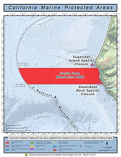
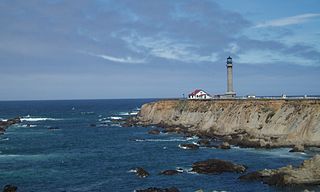
The South Cape Mendocino State Marine Reserve is an offshore marine protected area located off Cape Mendocino and the coastal town of Petrolia about 30 miles (48 km) south of Eureka. It marks California’s westernmost point. The area is one of the most undeveloped sections of the California coast, and its waters are homes to important bird and mammal species. Within the South Cape Mendocino State Marine Reserve, the take of all living marine resources is prohibited.

Greenly Island is an island in the Australian state of South Australia located in the Great Australian Bight about 30 kilometres (19 mi) west-south-west of Point Whidbey on Eyre Peninsula. The island is uninhabited by humans and provides a haven for marine and terrestrial wildlife. The island and its intertidal zone constitute the Greenly Island Conservation Park. Its adjacent waters are occasionally visited by fishermen targeting yellowtail kingfish.

Neptune Islands Conservation Park is a protected area occupying most of the Neptune Islands in South Australia about 55 km (34 mi) south-south east of Port Lincoln. It was established in 1967 principally to protect a New Zealand fur seal breeding colony. The conservation park was subsequently expanded to include the adjoining waters in order to control and manage berleying activities used to attract great white sharks. As of 2002, the conservation park is the only place in Australia where shark cage diving to view great white sharks is legally permitted.

Nicolas Baudin Island Conservation Park is a protected area associated with Nicolas Baudin Island which is located off Cape Blanche on the west coast of Eyre Peninsula in South Australia about 30 kilometres south of Streaky Bay. The conservation park was proclaimed in 2003 under the National Parks and Wildlife Act 1972 to ‘protect a significant breeding location for the Australian sea lion.’
Nicolas Baudin Island is an island in the Australian state of South Australia about 500 metres west of Cape Blanche on the west coast of Eyre Peninsula about 25 kilometres south south-west of the town of Streaky Bay. The island is notable as a breeding site for Australian sea lions. The island has enjoyed protected area status since 2003 when it became part of the Nicolas Baudin Island Conservation Park.

Scott Islands Marine National Wildlife Area is a National Wildlife Area off the northwestern tip of Vancouver Island in British Columbia, Canada. Covering an area of 11,570.65 km (7,189.67 mi), it is the second largest protected area in British Columbia after Offshore Pacific Seamounts and Vents Closure and is the largest national wildlife area in Canada.


