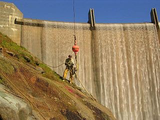
Englebright Dam is a 280 ft (85 m) high variable radius concrete arch dam on the Yuba River in the Sacramento River Basin, located in Yuba and Nevada counties of California, United States. It was put into service in 1941 by the United States Army Corps of Engineers.

Cull Canyon Regional Recreation Area (CCRRA) is a regional park located in Castro Valley, Alameda County, California. It is part of the East Bay Regional Park District (EBRPD) system.

Mountain Park Dam is located just upstream of Snyder Dam, on Otter Creek near Mountain Park, Oklahoma. Snyder Lake was drained to accommodate construction of Mountain Park Dam, then restored upon completion of construction, which was performed by O'Neal Construction, Inc. of Ann Arbor, MI. The lake is maintained at sufficient elevation to provide a plunge pool for water released or spilled from the dam. Mountain Park dam impounds the waters of Tom Steed Reservoir.

San Juan Creek, also called the San Juan River, is a 29-mile (47 km) long stream in Orange and Riverside Counties, draining a watershed of 133.9 square miles (347 km2). Its mainstem begins in the southern Santa Ana Mountains in the Cleveland National Forest. It winds west and south through San Juan Canyon, and is joined by Arroyo Trabuco as it passes through San Juan Capistrano. It flows into the Pacific Ocean at Doheny State Beach. State Route 74, the Ortega Highway, crosses the Santa Ana Mountains via San Juan Canyon.
The Central Utah Project is a United States federal water project that was authorized for construction under the Colorado River Storage Project Act of April 11, 1956, as a participating project. In general, the Central Utah Project develops a portion of Utah's share of the yield of the Colorado River, as set out in the Colorado River Compact of 1922.

Aliso Creek is a 19.8-mile (31.9 km)-long, mostly urban stream in south Orange County, California. Originating in the Cleveland National Forest in the Santa Ana Mountains, it flows generally southwest and empties into the Pacific Ocean at Laguna Beach. The creek's watershed drains 34.9 square miles (90 km2), and it is joined by seven main tributaries. As of 2018, the watershed had a population of 144,000 divided among seven incorporated cities.
Oso Creek is an approximately 13.5-mile (21.7 km) tributary of Arroyo Trabuco in southern Orange County in the U.S. state of California. Draining about 20 square miles (52 km2) in a region north of the San Joaquin Hills and south of the Santa Ana Mountains, the creek is Trabuco Creek's largest tributary, and is part of the San Juan Creek drainage basin. Beginning in the foothills of the Santa Ana Mountains near the city of Mission Viejo, the creek is dammed twice to form Upper Oso Reservoir and Lake Mission Viejo. The creek is channelized and polluted along much of its length.

Coyote Lake is an artificial lake in Santa Clara County, California, United States, between Morgan Hill and Gilroy.
The Sierra Madre Dam is a dam on Little Santa Anita Creek, at the mouth of Little Santa Anita Canyon, in Los Angeles County, California. It is in the San Gabriel Mountains, south of the Angeles National Forest, on the northern border of Sierra Madre.

Laguna Niguel Lake, formerly known as Sulphur Creek Reservoir, is an artificial 44-acre (180,000 m2) fishing and recreational lake in Laguna Niguel, California. It is created by the Sulphur Creek Dam, which was completed in 1966. It is located at 33°32′59″N117°42′22″W and is 190 feet (58 m) above sea level. It is fed from two sources, one of which is Sulphur Creek itself and the other, a storm drain. It is accessed from La Paz Road, which runs along its east shore. Surrounding the reservoir is the Laguna Niguel Regional Park. In addition, within the lake on the large island is a protected bird sanctuary.

Anderson Lake, also known as Anderson Reservoir, is an artificial lake in Morgan Hill, located in southern Santa Clara County, California. The reservoir is formed by the damming of Coyote Creek just below its confluence with Las Animas Creek. A 4,275-acre (1,730 ha) county park surrounds the reservoir and provides limited fishing, picnicking, and hiking activities. Although swimming is prohibited, boating, water-skiing, and jet-skiing are permitted in the reservoir.
Laguna Niguel Regional Park is a public park in Laguna Niguel, in southern Orange County, California. Its main feature is Laguna Niguel Lake, located within the park's boundaries.
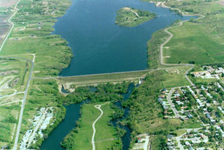
The Jamestown Dam is a rolled-earth dam spanning the James River in Stutsman County in the U.S. state of North Dakota, serving the primary purpose of flood control. It is north of the city of Jamestown, North Dakota. Built from April 1952 to September 1953, the dam measures 1,418 feet (432 m) long at the crest and 85 feet (26 m) high. It impounds the James River to form the Jamestown Reservoir. A small islet lies shortly upstream of the dam, where the James River previously split into two channels.

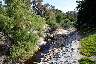
Sulphur Creek is an approximately 4.5-mile (7.2 km) tributary of Aliso Creek in Orange County, California. The creek drains about 6 square miles (16 km2) in the suburban cities of Laguna Niguel and Laguna Hills. Although most of its watershed has been utilized for master planned residential development, the creek retains a natural channel with riparian and wetland habitat in parts of Laguna Niguel Regional Park and Aliso and Wood Canyons Regional Park. Urban runoff has changed the once seasonal creek into a perennial stream.

Calero Reservoir, also called Calero Lake, is a reservoir in San Jose, California, located in the Calero neighborhood of Almaden Valley in South San Jose. It is the site of Calero County Park, which also includes a large area covering the lake and hundreds of acres of hills around it.
Santiago Dam is an earth/rockfill dam across Santiago Creek in Orange County, in the U.S. state of California, forming Irvine Lake. The 136-foot (41 m) earth dam and its reservoir serve for flood control and recreational purposes. It lies upstream (southeast) from the city of Orange and north of Irvine. Irvine Lake is the largest body of fresh water entirely in Orange County.
Gibraltar Dam is located on the Santa Ynez River, in southeastern Santa Barbara County, California, in the United States. Forming Gibraltar Reservoir, the dam is owned by the city of Santa Barbara. Originally constructed in 1920 and expanded in 1948, the dam and reservoir are located in a remote part of the Los Padres National Forest.

Antelope Dam or Antelope Valley Dam is a dam in Plumas County, California, part of the California State Water Project.

Heron Dam is a storage dam Rio Arriba County, in northern New Mexico in the southwestern United States, just north of the El Vado Dam. It is owned and operated by the United States Bureau of Reclamation. The dam is about 9 miles west of the town of Tierra Amarilla.

Brantley Dam is a flood-control and irrigation water-storage dam on the Pecos River in Eddy County, New Mexico, about 13 miles (21 km) north of Carlsbad, New Mexico, and 10 miles (16 km) upstream from Avalon Dam.


