Greenbrier County is a county in the U.S. state of West Virginia. As of the 2020 census, the population was 32,977. Its county seat is Lewisburg. The county was formed in 1778 from Botetourt and Montgomery counties in Virginia.
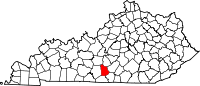
Metcalfe County is a county located in the U.S. state of Kentucky. Its county seat and only municipality is Edmonton. The county was founded in May 1860 and named for Thomas Metcalfe, Governor of Kentucky from 1828 to 1832. Metcalfe County is part of the Glasgow, KY Micropolitan Statistical Area, which is also included in the Bowling Green-Glasgow, KY Combined Statistical Area.

Barren County is a county located in the south-central portion of the U.S. state of Kentucky. As of the 2020 census, the population was 44,485. Its county seat is Glasgow. The county was founded on December 20, 1798, from parts of Warren and Green Counties. It was named for the Barrens, meadowlands that cover the northern third, though actually the soil is fertile. Barren County is part of the Glasgow, KY Micropolitan Statistical Area, which is also included in the Bowling Green-Glasgow, KY Combined Statistical Area. In 2007 Barren County was named the "Best Place to Live in Rural America" by Progressive Farmer Magazine.

Dry Ridge is a home rule-class city in Grant County, Kentucky, in the United States. The population was 2,191 at the 2010 census, up from 1,995 at the 2000 census. From around 1910 to 1960, the city's economy was dominated by business related to its mineral water wells, purported to have healing properties.
Sulphur City is an unincorporated community in Mineral County, West Virginia, United States. Sulphur City is located along West Virginia Route 42.
Bend is an unincorporated community in Lampasas and San Saba counties in western Central Texas. Its population was 1,678 as of the 2010 census.
Sulphur Springs is a neighborhood and district located within the city limits of Tampa, Florida. At the time of the 2010 census, there were 5,727 residents, down somewhat from the 2000 census count of 6,308. In the late 19th century the mineral springs were a draw. In the 1940s, the area was a major tourist attraction, featuring a 40-foot water slide and gator farm. Today, one of the primary draws to the area is Busch Gardens Tampa, a world-famous animal theme park and amusement park, located only 2.8 miles from Sulphur Springs. It is also the location of the Sulphur Springs History and Heritage Museum. Other nearby attractions and institutions include Adventure Island, The Florida Aquarium, the Museum of Science & Industry and the Universities of South Florida (USF) and Tampa (UT).
Summer Shade is an unincorporated community and census-designated place (CDP) in Metcalfe County, Kentucky, United States. As of the 2020 census, the population was 294.

Kentucky Route 90 is a major east–west state highway in southern Kentucky. The route is 134.734 miles (216.833 km) long, and it traverses Barren, Metcalfe, Cumberland, Clinton, Wayne, Pulaski, McCreary and Whitley Counties in southern Kentucky. It runs from the KY 70 junction near Interstate 65 in Cave City to US 25W about 8 miles (13 km) from Interstate 75.

Kentucky Route 70 (KY 70) is a long east-east state highway that originates at a junction with U.S. Route 60 (US 60) in Smithland in Livingston County, just east of the Ohio River. The route continues through the counties of Crittenden, Caldwell, Hopkins, Muhlenberg, Butler, Edmonson, Barren, Barren, Metcalfe, Green, Taylor, Casey, Pulaski, Lincoln and back into Pulaski again to terminate at a junction with US 150 near Maretburg in Rockcastle.

Salt Sulphur Springs is an unincorporated community in Monroe County, West Virginia, United States. Salt Sulphur Springs is located on U.S. Route 219, southwest of Union.
'Knob Lick' is an unincorporated community in Metcalfe County, Kentucky, United States. Knob Lick is located on Kentucky Route 70, 8 miles (13 km) northwest of Edmonton. Knob Lick has a post office with ZIP code 42154.
Mud Lick is a rural unincorporated community in Monroe County, Kentucky, United States. It is concentrated around the intersection of Kentucky Route 63 and Kentucky Route 870, northwest of Tompkinsville.

Seminole Hot Springs is an unincorporated community in Los Angeles County, California, United States. Seminole Hot Springs is located in the Santa Monica Mountains near Cornell, 3.6 miles (5.8 km) south-southeast of Agoura Hills at an elevation of 932 feet (284 m).

Wisdom is an unincorporated community located in Metcalfe County, Kentucky, United States. It was also known as Nicols and Old Randolph.
The Roller Coaster Yard Sale, sometimes referred to as the Roller Coaster Fair, is an outdoor second-hand sale held annually for three days beginning the first Thursday in October. It takes place along several U.S. and state routes in southern Kentucky and northern middle Tennessee.

Kentucky Route 163 (KY 163) is a 29.823-mile-long (47.995 km) state highway that traverses through two counties in south-central Kentucky. It runs from Tennessee State Route 51 at the Kentucky-Tennessee border south of Hestand to U.S. Route 68, Kentucky Route 80, and East Stockton Street in Edmonton via Tompkinsville.

Kentucky Route 218 is a 31.113-mile-long (50.072 km) west-east state highway that traverses three counties in south-central Kentucky. It is locally known as LeGrande Highway from Horse Cave to near Shady Grove.
Sulphur Lick is a rural unincorporated community in northwestern Monroe County, Kentucky, United States. The community is located around the intersection of Kentucky Route 678 and Kentucky Route 839.