Whatcom County is a county located in the northwestern corner of the U.S. state of Washington, bordered by the Lower Mainland of British Columbia to the north, Okanogan County to the east, Skagit County to the south, San Juan County across Rosario Strait to the southwest, and the Strait of Georgia to the west. Its county seat and largest population center is the coastal city of Bellingham, comprising the Bellingham, WA Metropolitan Statistical Area, and as of the 2020 census, the county's population was 226,847.

The Continental Divide of the Americas is the principal, and largely mountainous, hydrological divide of the Americas. The Continental Divide extends from the Bering Strait to the Strait of Magellan, and separates the watersheds that drain into the Pacific Ocean from those river systems that drain into the Atlantic and Arctic Ocean, including those that drain into the Gulf of Mexico, the Caribbean Sea, and Hudson Bay.

The North Cascades are a section of the Cascade Range of western North America. They span the border between the Canadian province of British Columbia and the U.S. state of Washington and are officially named in the U.S. and Canada as the Cascade Mountains. The portion in Canada is known to Americans as the Canadian Cascades, a designation that also includes the mountains above the east bank of the Fraser Canyon as far north as the town of Lytton, at the confluence of the Thompson and Fraser Rivers.

Mount Harvard is the third highest summit of the Rocky Mountains of North America and the U.S. state of Colorado. The prominent 14,421-foot (4395.6 m) fourteener is the highest summit of the Collegiate Peaks and the fourth highest summit in the contiguous United States. Mount Harvard is located in the Collegiate Peaks Wilderness of San Isabel National Forest, 11.7 miles (18.9 km) northwest by west of the Town of Buena Vista in Chaffee County, Colorado, United States. The summit of Mount Harvard is the highest point in Chaffee County and is higher than any point in the United States east of its longitude. The mountain was named in honor of Harvard University.

Mount Frissell, 2,454 feet (748 m), which straddles the border of southwest Massachusetts and northwest Connecticut, is part of the Taconic Range. Frissell's south slopes include the highest point in Connecticut, a popular destination for highpointers.

The Vedder River, called the Chilliwack River above Vedder Crossing, is a river in the Canadian province of British Columbia and the U.S. state of Washington.

State Route 9 (SR 9) is a 98.17-mile (157.99 km) long state highway traversing three counties, Snohomish, Skagit, and Whatcom, in the U.S. state of Washington. The highway extends north from an interchange with SR 522 in the vicinity of Woodinville north through Snohomish, Lake Stevens, Arlington, Sedro-Woolley, and Nooksack to become British Columbia Highway 11 (BC 11) at the Canada–US border in Sumas. Three other roadways are briefly concurrent with the route: SR 530 in Arlington, SR 20 in Sedro-Woolley, and SR 542 near Deming. A spur route in Sumas serves trucks traveling into British Columbia.

Roan Mountain is a 6,277 ft (1,913 m) mountain straddling the North Carolina/Tennessee border in the Unaka Range of the Southern Appalachian Mountains in the Southeastern United States. The range's highpoint, Roan is clad in a dense stand of Southern Appalachian spruce-fir forest, and includes the world's largest natural rhododendron garden, and the longest stretch of grassy bald in the Appalachian range. The Roan Highlands also contain the highest quality remaining stretch of Fraser fir forest throughout the tree's entire range. The Cherokee National Forest and Pisgah National Forest converge atop the mountain, with Roan Mountain State Park located near its northern base. The Appalachian Trail traverses most of the Roan's crest. The Roan High Knob Shelter is the highest back-country shelter on the entire 2,174-mile (3,499 km) trail.
Lincoln Peak is a mountain located on the border between Addison and Washington counties in the U.S. state of Vermont. It is part of the Lincoln Mountain section of the Green Mountains in the Green Mountain National Forest. Lincoln Peak is flanked to the southwest by Mount Abraham, and to the north by Nancy Hanks Peak, which was named after Abraham Lincoln's assassination.
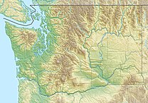
State Route 546 (SR 546) is a state highway in Whatcom County, Washington, United States. It runs east–west for 8 miles (13 km) near the Canadian border, connecting SR 539 near Lynden to SR 9 near Nooksack and Sumas. The highway is a major freight corridor and serves as an alternate route between Bellingham and the Sumas border crossing.

State Route 547 (SR 547) is a Washington state highway located in Whatcom County, south of the Canada–US border. The 10.79-mile (17.36 km) long route runs northwest from SR 542 in Kendall to SR 9 in Sumas. The highway was originally created in 1984, but a road extending from Kendall to Sumas has been on maps since 1966 along the Sumas–Glacier route of the Chicago, Milwaukee, St. Paul and Pacific Railroad.

Sugarloaf Mountain is a mountain located in Greene County, New York. The mountain is part of the Devil's Path range of the Catskill Mountains. To the northwest, Sugarloaf is separated from Plateau Mountain by Mink Hollow Notch; to the southeast, Sugarloaf is separated from Twin Mountain by Pecoy Notch.

Plateau Mountain is located in the town of Hunter in Greene County, New York, United States. It is part of the Devil's Path range of the Catskill Mountains. Plateau has a two-mile-long (3.2 km) summit ridge above 3,500 feet (1,100 m). The highest point, at least 3,840 feet (1,170 m), is at the southeast end, facing Sugarloaf Mountain to the east across Mink Hollow Notch. It is the 12th-highest peak in the range Devils Tombstone is located west of Plateau Mountain. The northwest end faces Hunter Mountain to the west across 1,400-foot deep (430 m) Stony Clove Notch.

U.S. Route 97 in the U.S. state of Washington is a 322-mile (518 km) route which traverses from the Oregon state line at the northern end of the Sam Hill Memorial Bridge in Maryhill, north to the Canada–US border in Okanogan County near Oroville. The highway serves major cities such as Goldendale, Yakima, Ellensburg and Wenatchee before continuing towards the Alaska Highway at the Yukon border as British Columbia Highway 97. Along the length of the roadway, US 97 is concurrent with State Route 14 in Maryhill, Interstate 82 (I-82) and US 12 between Union Gap and Ellensburg, I-90 briefly in Ellensburg, US 2 between Peshastin and rural Douglas County and SR 20 near Omak. An alternate route connects the highway with Chelan.

The Sumas River is a river in the Fraser Lowland and a tributary of the Fraser River system, coursing across the international border between the Canadian province of British Columbia and the U.S. state of Washington.

Buckner Mountain is a tall peak in the North Cascades of Washington state and in the Stephen Mather Wilderness of North Cascades National Park. At 9,114 feet (2,778 m) in elevation it is the highest in Skagit County and one of about ten of Washington's non-volcanic peaks above 9,000 feet high. It is ranked as the 14th highest peak in the state, and the third highest peak in North Cascades National Park.

Boston Peak is a tall peak in the North Cascades in the U.S. state of Washington and within North Cascades National Park. At 8,894 feet (2,711 m) in elevation it is the 26th highest peak in Washington. Its nearest higher neighbor is Buckner Mountain, 1.66 miles (2.67 km) to the east.

Mount Spickard is a 8,980-foot (2,740 m) mountain peak in the North Cascades, a mountain range in the U.S. state of Washington. Located 2 miles (3.2 km) south of the Canada–US border, it is part of the Chilliwack Group, a subrange of the Skagit Range which is part of the North Cascades. It is composed mainly of gneiss and is part of two major drainage basins: that of the Skagit River and Fraser River.

Deadwood Peak is a 6,280-foot-elevation mountain summit located on the eastern border of Mount Rainier National Park. It is also situated on the shared border of Pierce County and Yakima County in Washington state. Deadwood Peak is set on the crest of the Cascade Range, immediately north of Yakima Peak and Chinook Pass, with the Pacific Crest Trail traversing its east slope. Its nearest higher peak is Naches Peak, 0.59 mi (0.95 km) to the southeast. Deadwood Peak takes its name from Deadwood Lakes and Deadwood Creek to its northwest, and their names came from the large number of downed trees in the area. From Chinook Pass, a short scramble up the south side leads to the summit with unobstructed views of Mount Rainier.

Apex Mountain is an 8,302-foot (2,530-metre) summit located in Okanogan County in Washington state. It is part of the Okanogan Range which is a sub-range of the North Cascades. The mountain is situated 2.5 miles (4.0 km) south of the Canada–United States border, on the east side of the Cascade crest, in the Pasayten Wilderness, on land managed by the Okanogan–Wenatchee National Forest. The nearest higher peak is Amphitheater Mountain, 2.35 miles (3.78 km) to the west-northwest. The Pacific Northwest Trail traverses the northern slopes of Apex Mountain as it crosses Apex Pass. Precipitation runoff from Apex Mountain drains west into Cathedral Creek, or east into Tungsten Creek, both tributaries of the Chewuch River. Topographic relief is significant as the summit rises 1,200 feet above Tungsten Lake in 0.3 mile (0.5 km).