Related Research Articles

The Mojave River is an intermittent river in the eastern San Bernardino Mountains and the Mojave Desert in San Bernardino County, California, United States. Most of its flow is underground, while its surface channels remain dry most of the time, except for the headwaters and several bedrock gorges in the lower reaches.

The San Bernardino Mountains are a high and rugged mountain range in Southern California in the United States. Situated north and northeast of San Bernardino and spanning two California counties, the range tops out at 11,503 feet (3,506 m) at San Gorgonio Mountain – the tallest peak in all of Southern California. The San Bernardinos form a significant region of wilderness and are popular for hiking and skiing.

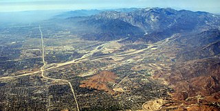
Cajon Pass is a mountain pass between the San Bernardino Mountains to the east and the San Gabriel Mountains to the west in Southern California. Created by the movements of the San Andreas Fault, it has an elevation of 3,777 ft (1,151 m). Located in the Mojave Desert, the pass is an important link from the Greater San Bernardino Area to the Victor Valley, and northeast to Las Vegas. The Cajon Pass area is on the Pacific Crest Trail.

The Victor Valley is a valley in the Mojave Desert and subregion of the Inland Empire, in San Bernardino County in Southern California.

The Old Spanish Trail is a historical trade route that connected the northern New Mexico settlements of Santa Fe, New Mexico with those of Los Angeles, California and southern California. Approximately 700 mi (1,100 km) long, the trail ran through areas of high mountains, arid deserts, and deep canyons. It is considered one of the most arduous of all trade routes ever established in the United States. Explored, in part, by Spanish explorers as early as the late 16th century, the trail was extensively used by traders with pack trains from about 1830 until the mid-1850s.

The San Bernardino Valley is a valley in Southern California, USA located at the south base of the Transverse Ranges. It is bordered on the north by the eastern San Gabriel Mountains and the San Bernardino Mountains; on the east by the San Jacinto Mountains; on the south by the Temescal Mountains and Santa Ana Mountains; and on the west by the Pomona Valley. Elevation varies from 590 feet (180 m) on valley floors near Chino to 1,380 feet (420 m) near San Bernardino and Redlands. The valley floor is home to over 80% of the more than 4 million people of the Inland Empire region.
Lytle Creek, California, is an approximately 18-mile-long (29 km) stream in southwestern San Bernardino County near the city of San Bernardino. It is a tributary of Warm Creek, a tributary of the Santa Ana River. The Mormon settlers of San Bernardino named the stream "Lytle Creek" after their leader, Captain Andrew Lytle. The Tongva village of Wa’aachnga was located along Lytle Creek.

The Mojave Road, also known as Old Government Road, is a historic route and present day dirt road across what is now the Mojave National Preserve in the Mojave Desert in the United States. This rough road stretched 147 miles (237 km) from Beale's Crossing, to Fork of the Road location along the north bank of the Mojave River where the old Mojave Road split off from the route of the Old Spanish Trail/Mormon Road.

Glen Helen Regional Park is a county park located in San Bernardino, California, United States adjacent to the Cajon Pass. It was the site of both US Festivals of the early 1980s. It is also home to the Glen Helen Amphitheater, the largest outdoor amphitheater in the United States. The park also hosts several off-road races since 1985.
Monument Peak is a summit in the San Bernardino Mountains, of San Bernardino County, California. It lies at an elevation of 5272 feet.
Crowder Canyon, originally Coyote Canyon, is a valley in San Bernardino County, California. Its mouth was at an elevation of 2,999 feet / 914 meters at its confluence with Cajon Canyon. Its source was at an elevation of 4200 feet at 34°21′02″N117°26′04″W near Cajon Summit. The canyon runs southward just west of the top of Cajon Pass then turns southwestward to meet Cajon Canyon.
Cajon Canyon, originally named El Cajon De San Gabriel De Amuscopiabit, El Cajon in Spanish meaning "the box" in English, is a long valley ending in a box canyon in the northeastern San Gabriel Mountains, within San Bernardino County, California.
Horsethief Canyon, is a canyon comprising the upper part of the Summit Valley in San Bernardino County, California. Its head lies at 34°19′33″N117°25′38″W at an elevation of 3,800 feet just east of the summit of Cajon Pass, and its mouth at an elevation of 3,123 feet / 952 meters. California State Routes 138 and 173 pass through it.

The Mohave Trail was a Native American trade route between Mohave Indian villages on the Colorado River and settlements in coastal Southern California.
Sawpit Canyon is a steep valley or canyon in the San Bernardino Mountains of San Bernardino County, California. Its mouth is at an elevation of 3,386 feet / 1,032 meters. Its source is located at 34°14′43″N117°20′56″W and lies at an elevation of 5,100 feet, just east of Monument Peak. Its creek was a tributary of the West Fork Mojave River, its original mouth now under Silverwood Lake.
West Fork Mojave River is a tributary stream of the Mojave River in the San Bernardino Mountains of San Bernardino County, California. Its mouth lies at an elevation of 2,986 feet / 910 meters at its confluence with Deep Creek, together the source of the Mojave River. The source of the West Fork is at 34°15′52″N117°24′01″W at an elevation of 4,960 feet, on the north side of a saddle between summits on a ridge running west northwest of Sugarpine Mountain. Sawpit Canyon Creek and East Fork of West Fork Mojave River are its tributaries, both of which now feed into Silverwood Lake that was created when the West Fork was obstructed by the Cedar Springs Dam in 1971.
East Fork of West Fork Mojave River is a tributary stream of the West Fork Mojave River, itself a tributary of the Mojave River, in the San Bernardino Mountains of San Bernardino County, California. Its mouth originally was at its confluence with the West Fork Mojave River which is now submerged under Lake Silverwood. It now lies at an elevation of 3,376 feet / 1,029 meters at its confluence with that lake. The source of the East Fork is at 34°15′11″N117°14′24″W at an elevation of 5,500 feet in Twin Peaks, California.
Cable Canyon is a valley on the south slope of the San Bernardino Mountains in San Bernardino County, California. Its mouth lies at an elevation of 2,073 feet / 632 meters. Its source is at 34°13′48″N117°22′19″W, the confluence of West Fork Cable Canyon and East Fork Cable Canyon, at an elevation of 2,671 feet / 814 meters.
Mormon Road, also known to the 49ers as the Southern Route, of the California Trail in the Western United States, was a seasonal wagon road pioneered by a Mormon party from Salt Lake City, Utah led by Jefferson Hunt, that followed the route of Spanish explorers and the Old Spanish Trail across southwestern Utah, northwestern Arizona, southern Nevada and the Mojave Desert of California to Los Angeles in 1847. From 1855, it became a military and commercial wagon route between California and Utah, called the Los Angeles – Salt Lake Road. In later decades this route was variously called the "Old Mormon Road", the "Old Southern Road", or the "Immigrant Road" in California. In Utah, Arizona and Nevada it was known as the "California Road".

The Santa Fe And Salt Lake Trail Monument was designated a California Historic Landmark (No.576) on May 17, 1957. Santa Fe And Salt Lake Trail Monument marks the place two Historic trail merged in Cajon Pass in San Bernardino County, California. The Old Spanish Trail and the Mohave Trail-Mojave Road merged in Cajon Pass. The large white marker is just off the Interstate 15 in Cajon Pass, was U.S. Route 66 in the past. It was built by the Pioneer Society of San Bernardino to remember and honor the pioneers that came west. The marker is 12 feet tall and 7 feet square at the base. Cajon Pass was home to the Serrano Indian, Native Californians that lived in the nearby Atongaibit village, in what is now Hesperia.
References
Coordinates: 34°20′17″N117°16′12″W / 34.33806°N 117.27000°W