
Riley County is a county located in the U.S. state of Kansas. Its county seat and largest city is Manhattan. As of the 2020 census, the population was 71,959. The county was named after Bennet Riley, the 7th governor of California, and a Mexican–American War hero. Riley County is home to Fort Riley and Kansas State University.

Pottawatomie County is a county located in the U.S. state of Kansas. Its county seat is Westmoreland. As of the 2020 census, the county population was 25,348. The county was named for the Potawatomi tribe.

Miami County is a county located in east-central Kansas and is part of the Kansas City metropolitan area. Its county seat and most populous city is Paola. As of the 2020 census, the county population was 34,191. The county was named for the Miami tribe.
Osawatomie is a city in Miami County, Kansas, United States, 61 miles (98 km) southwest of Kansas City. As of the 2020 census, the population of the city was 4,255. It derives its name as a portmanteau of two nearby streams, the Marais des Cygnes River and Pottawatomie Creek.
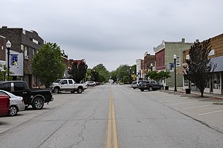
Westmoreland is a city in and the county seat of Pottawatomie County, Kansas, United States. As of the 2020 census, the population of the city was 740.
Manhattan is a city in, and the county seat of, Riley County, Kansas, United States, although the city extends into Pottawatomie County. It is located in northeastern Kansas at the junction of the Kansas River and Big Blue River. As of the 2020 Census, the population of the city was 54,100.

St. Marys or Saint Marys is a city in Pottawatomie and Wabaunsee counties in the U.S. state of Kansas in the United States. As of the 2020 census, the population of the city was 2,759. It is home of Saint Mary's Academy and College.
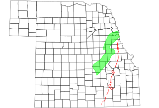
The Humboldt Fault or Humboldt Fault Zone, is a normal fault or series of faults, that extends from Nebraska southwestwardly through most of Kansas.

Manhattan Area Technical College is a public technical college in Manhattan, Kansas, United States. It was founded in 1965 and offers Associate of Applied Science degrees in 8 disciplines and technical certificate programs in several others. Manhattan Area Technical College is accredited through the Higher Learning Commission. The college's primary service area includes Geary, Riley, Clay, Marshall, Dickinson, and Pottawatomie Counties.

U.S. Route 24 (US-24) in the state of Kansas runs east–west across the northern half of the state for 435.95 miles (701.59 km). The route mostly connects rural communities across the High Plains of Kansas, while also later providing an interstate alternate between Topeka, Lawrence, and Kansas City. US 24 both enters and exits the state running concurrently with Interstate 70 (I-70). Along with US 40, the road has largely been replaced by the more modern Interstate in its functionality as a long-distance route.

Fostoria is an unincorporated community in Pottawatomie County, Kansas, United States. Fostoria is 6 miles (9.7 km) east of Olsburg. Fostoria has a post office with ZIP code 66426.
Blaine is an unincorporated community in Pottawatomie County, Kansas, United States. It is located 29 miles northeast of Manhattan at the crossroads of K-99 and K-16.
Duluth is an unincorporated community in Pottawatomie County, Kansas, United States.
Flush is an unincorporated community in Pottawatomie County, Kansas, United States. It is located between St George and Westmoreland.
Saint Clere is an unincorporated community in Pottawatomie County, Kansas, United States.

K-13 is a 14.62-mile-long (23.53 km) state highway in the northeastern part of the US state of Kansas. It begins at U.S. Route 24 (US-24) north of Manhattan and runs north to K-16 southwest of Fostoria. K-13 serves as the only northeasterly route out of Manhattan. The majority of the highway is exclusively in Pottawatomie County, with less than a mile of it existing in Riley County. The first two miles (3.2 km) traverse Tuttle Creek State Park, and crosses the Tuttle Creek Lake dam.

National Weather Service – Topeka, Kansas is a local National Weather Service forecast office based in Topeka, the state capital of Kansas. Its offices are located near Philip Billard Municipal Airport. It provides weather and emergency information to 23 counties in north-central, northeast, and east-central Kansas. Communities that rely on the Topeka Weather Office for forecasts and severe storm warnings include Abilene, Clay Center, Concordia, Council Grove, Emporia, Hiawatha, Junction City, Lawrence, Manhattan, Marysville, Ottawa, and Topeka.

Kansas's 1st Senate district is one of 40 districts in the Kansas Senate. It has been represented by Independent Dennis Pyle since 2005.

Kansas's 17th Senate district is one of 40 districts in the Kansas Senate. It has been represented by Republican Jeff Longbine, the current Vice President of the Senate, since his appointment in 2010.
Manhattan–Ogden USD 383 is a public unified school district headquartered in Manhattan, Kansas, United States. The district includes the communities of Manhattan, Ogden, Swamp Angel, and nearby rural areas.


