
The Snake River is a major river in the interior Pacific Northwest region of the United States. About 1,080 miles (1,740 km) long, it is the largest tributary of the Columbia River, which is the largest North American river that empties into the Pacific Ocean. Beginning in Yellowstone National Park, western Wyoming, it flows across the arid Snake River Plain of southern Idaho, the rugged Hells Canyon on the borders of Idaho, Oregon and Washington, and finally the rolling Palouse Hills of southeast Washington. It joins the Columbia River just downstream from the Tri-Cities, Washington, in the southern Columbia Basin.

The Owyhee River is a tributary of the Snake River located in northern Nevada, southwestern Idaho and southeastern Oregon in the Western United States and its Pacific Northwest region. It is 280 miles (450 km) long. The river's drainage basin is 11,049 square miles (28,620 km2) in area, one of the largest subbasins of the Columbia River Basin with its major waterways of the Columbia River and Snake River. The mean annual discharge is 995 cubic feet per second (28.2 m3/s), with a maximum of 50,000 cu ft/s (1,400 m3/s) recorded in 1993 and a minimum of 42 cu ft/s (1.2 m3/s) in 1954.

The Palouse River is a tributary of the Snake River in Washington and Idaho, in the northwest United States. It flows for 167 miles (269 km) southwestwards, primarily through the Palouse region of southeastern Washington. It is part of the Columbia River Basin, as the Snake River is a tributary of the Columbia River.
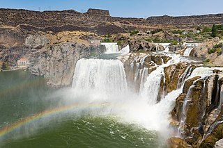
Shoshone Falls is a waterfall in the western United States, on the Snake River in south-central Idaho, approximately three miles (5 km) northeast of the city of Twin Falls. Sometimes called the "Niagara of the West," Shoshone Falls is 212 feet (65 m) in height, 45 feet (14 m) higher than Niagara Falls, and flows over a rim nearly one thousand feet (300 m) in width.

The National Register of Historic Places in the United States is a register including buildings, sites, structures, districts, and objects. The Register automatically includes all National Historic Landmarks as well as all historic areas administered by the U.S. National Park Service. Since its introduction in 1966, more than 97,000 separate listings have been added to the register.

The Coal River is a tributary of the Kanawha River in southern West Virginia. It is formed near the community of Alum Creek by the confluence of the Big and Little Coal Rivers, and flows generally northward through western Kanawha County, past the community of Upper Falls and into the Kanawha River at St. Albans.

The Morley Nelson Snake River Birds of Prey National Conservation Area has one of the densest populations of nesting raptors. The National Conservation Area (NCA) is located 35 miles (56 km) south of Boise, Idaho along 81 miles (130 km) of the Snake River, and is managed by the Bureau of Land Management. The NCA covers 484,873 acres (1,962.21 km2). In descending order of land area it is located in Ada, Elmore, Owyhee, and Canyon counties.

This is a directory of properties and districts included among the National Register of Historic Places listings in Idaho. There are approximately 1,000 sites in Idaho listed on the National Register. Each of the state's 44 counties has at least one listing on the National Register.

Hells Canyon National Recreation Area is a United States national recreation area on the borders of the U.S. states of Oregon and Idaho. Managed by the U.S. Forest Service as part of the Wallowa-Whitman National Forest, the recreation area was established by Congress and signed by President Gerald Ford in late 1975 to protect the historic and archaeological values of the Hells Canyon area and the area of the Snake River between Hells Canyon Dam and the Oregon–Washington border.

The Raystown Branch Juniata River is the largest and longest tributary of the Juniata River in south-central Pennsylvania in the United States.

Milner Dam is a rockfill dam near Burley in south central Idaho. It impounds the Snake River in a reservoir named Milner Lake. The dam spans the river across two islands, with three embankments.

Swan Falls Dam is a concrete gravity type hydroelectric dam in the western United States, on the Snake River in southwestern Idaho, United States. At the dam, the river is the border of Ada and Owyhee counties; it is approximately five miles (8 km) east of Murphy, the seat of Owyhee County.

Salmon Falls Creek is a tributary of the Snake River, flowing from northern Nevada into Idaho in the United States. Formed in high mountains at the northern edge of the Great Basin, Salmon Falls Creek flows northwards 121 miles (195 km), draining an arid and mountainous basin of 2,103 square miles (5,450 km2). The Salmon Falls Creek valley served as a trade route between the Native American groups of the Snake River Plain and Great Basin. Today, most of its water is used for irrigation.

Fall River rises on the Madison and Pitchstone Plateaus in the southwest corner of Yellowstone National Park, Wyoming and flows approximately 64 miles (103 km) to its confluence with the Henrys Fork of the Snake River near Ashton, Idaho. Historically, the river was referred to as the Middle Fork of the Snake River or as Fall River or the Falls River by trappers and prospectors as early as the 1830s. It was officially named the Falls River by the 1872 Hayden Geological Survey, but was always called Fall River by the locals and so the U.S. Board on Geographic Names changed the official name to Fall River in 1997 at the request of Idaho authorities. The river is home to numerous waterfalls and cascades in its upper reaches.

The Minidoka Project is a series of public works by the U.S. Bureau of Reclamation to control the flow of the Snake River in Wyoming and Idaho, supplying irrigation water to farmlands in Idaho. One of the oldest Bureau of Reclamation projects in the United States, the project involves a series of dams and canals intended to store, regulate and distribute the waters of the Snake, with electric power generation as a byproduct. The water irrigates more than a million acres (4,000 km²) of otherwise arid land, producing much of Idaho's potato crop. Other crops include alfalfa, fruit and sugar beets. The primary irrigation district lies between Ashton in eastern Idaho and Bliss in the southwestern corner of the state. Five main reservoirs collect water, distributing it through 1,600 miles (2,600 km) of canals and 4,000 miles (6,400 km) of lateral distribution ditches.

Salmon Falls Dam is a dam constructed across Salmon Falls Creek in Twin Falls County, Idaho, in the United States. Located about 28 miles (45 km) southwest of Twin Falls, the masonry arch-gravity dam is 217 feet (66 m) high and 450 feet (140 m) long, impounding up to 230,650 acre-feet (0.28450 km3) of water in Salmon Falls Creek Reservoir. When full, the reservoir extends for 17 miles (27 km) upstream, encompassing 3,400 acres (1,400 ha). The dam and reservoir control runoff from a drainage basin of 1,610 sq mi (4,200 km2).

Willow Creek is a 84-mile (135 km) long tributary of the Snake River in the U.S. state of Idaho. Beginning at an elevation of 6,568 feet (2,002 m) east of the Blackfoot Mountains in southeastern Bingham County, it flows generally north into Bonneville County and past Bone. South of the town of Ririe, the creek is impounded by Ririe Dam, forming Ririe Reservoir. It then turns southwest, passing between Iona and Ucon, before bifurcating into two distributaries, North Fork Willow Creek and South Fork Willow Creek, at an elevation of 4,777 feet (1,456 m). Both forks reach the Snake River north of Idaho Falls.
Salmon Falls is the series of falls on the Snake River, in Twin Falls County, Idaho, comprising the Upper Salmon Falls and Lower Salmon Falls, near Hagerman. The Upper Salmon Falls are about 40 miles West of Shoshone Falls, in between Gooding County and Twin Falls County, Idaho, USA. It is situated ≈ 25 miles below Anger Falls.
Lower Salmon Falls Dam is a concrete gravity-type hydroelectric dam on the Lower Salmon Falls of the Snake River, in the U.S. state of Idaho. The dam is located 5 miles downstream from Upper Salmon Falls, between Gooding County and Twin Falls County, Idaho.

The Guffey Butte–Black Butte Archeological District is a 14,000 acres (57 km2) historic district in southwestern Idaho, United States, that is listed on the National Register of Historic Places (NRHP). It includes numerous archeological sites in Ada, Canyon, Elmore, and Owyhee counties.


