
The Ohio River is a 981-mile-long (1,579 km) river in the United States. It is located at the boundary of the Midwestern and Southern United States, flowing in a southwesterly direction from western Pennsylvania to its mouth on the Mississippi River at the southern tip of Illinois. It is the third largest river by discharge volume in the United States and the largest tributary by volume of the north-south flowing Mississippi River, which divides the eastern from western United States. It is also the 6th oldest river on the North American continent. The river flows through or along the border of six states, and its drainage basin includes parts of 14 states. Through its largest tributary, the Tennessee River, the basin includes several states of the southeastern U.S. It is the source of drinking water for five million people.

Crater Lake is a volcanic crater lake in south-central Oregon in the Western United States. It is the main feature of Crater Lake National Park and is famous for its deep blue color and water clarity. The lake partly fills a 2,148-foot-deep (655 m) caldera that was formed around 7,700 years ago by the collapse of the volcano Mount Mazama. No rivers flow into or out of the lake; the evaporation is compensated for by rain and snowfall at a rate such that the total amount of water is replaced every 250 years. With a depth of 1,949 feet (594 m), the lake is the deepest in the United States. In the world, it ranks tenth for maximum depth, as well as third for mean (average) depth.

In Canadian folklore, the Ogopogo is a lake monster said to inhabit Okanagan Lake in British Columbia, Canada. Some scholars have charted the entity's development from First Nations folklore and widespread water monster folklore motifs. The Ogopogo now plays a role in the commercial symbolism and media representation of the region.

Lake Winnebago is a shallow freshwater lake in the north central United States, located in east central Wisconsin. At 137,700 acres, it is the largest lake entirely within the state, covering an area of about 30 miles by 10 miles with 88 miles of shoreline, an average depth of 15.5 feet, and a maximum depth of 21 feet. It has many shallow reefs along the west shore and a drop-off type shoreline on the east. There are several islands along the west shore.

Lake Nipissing is a lake in the Canadian province of Ontario. It has a surface area of 873.3 km2 (337.2 sq mi), a mean elevation of 196 m (643 ft) above sea level, and is located between the Ottawa River and Georgian Bay. Lake Nipissing is the third-largest lake entirely in Ontario. It is relatively shallow for a large lake, with an average depth of only 4.5 m (15 ft). The shallowness of the lake makes for many sandbars along the lake's irregular shoreline. The lake reaches a maximum depth of 64 m (210 ft) near the mouth of the French River, off the shore of Blueberry Island. The lake has many islands most of which are protected under the Protection of Significant Wetlands scheme, controlled by the Ministry of Natural Resources and Forestry.

Lake Waccamaw is a fresh water lake located in Columbus County in North Carolina. It is the largest of the natural Carolina Bay lakes. Although bay trees are present within many Carolina Bays, the term "bay" does not refer to the trees but comes instead from an early science publication by Glenn (1895), who used the word "bay" to refer to these features near the town of Darlington, South Carolina. Lake Waccamaw is fed by four creeks: First, Second, Third, and Big creeks. The outlet forms the Waccamaw River which flows south-southwest to empty into the Atlantic Ocean near Georgetown, South Carolina

Flathead Lake is a large natural lake in northwest Montana, United States.

Lake Wawasee, formerly Turkey Lake, is a natural lake southeast of Syracuse in Kosciusko County, Indiana, United States. It is the largest natural lake wholly contained within Indiana. It is located just east of Indiana State Road 13.

The Kettle is an 83.6-mile-long (134.5 km) tributary of the St. Croix River in eastern Minnesota in the United States. Via the St. Croix River, it is part of the watershed of the Mississippi River. The river's English name is due to the large number of large rounded holes (kettles) in the sandstone in and around the river, carved out by the swirling waters of the river. The river's Dakota name Céġa watpa entered into English via the Anishinaabe people's Akiko-ziibi, both meaning "Kettle River".
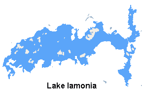
Lake Iamonia⟨aɪ ˈmoʊ njə⟩ is a large, subtropical prairie lake in northern Leon County, Florida, United States, created during the Pleistocene epoch.

Lake Chicago was a prehistoric proglacial lake that is the ancestor of what is now known as Lake Michigan, one of North America's five Great Lakes. Formed about 13,000 years ago and fed by retreating glaciers, it drained southwest through the Chicago Outlet River.

Dug Pond is a small body of water in Natick, Massachusetts. Most notably it is home to Memorial Beach, one of few swimming beaches in Natick, and its eastern shore is the site of Natick High School.
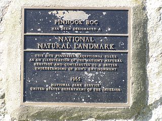
Pinhook Bog is a unique bog in Indiana that has been designated a National Natural Landmark. It is part of Indiana Dunes National Park, an area that many citizens, scientists, and politicians fought hard to preserve. Its sister bog, Volo Bog, is located nearby. The bog contains a large variety of plants, including insect eating plants, tamarack trees, stands of blueberry bushes, and floating mats of sphagnum moss. Pinhook Bog is about 580 acres (2.3 km2), a quarter of which is a floating mat of sphagnum peat moss. A "moat" separates the bog from the uplands.

Lake Papakeechie is a small man-made lake of 179 acres (0.72 km2) located in Kosciusko County, Indiana, United States. The lake is situated south of and drains into Lake Wawasee. The lake is owned by the papakeechie Protective Association.

Lake Wawasee is a large, natural, freshwater lake southeast of Syracuse in Kosciusko County, Indiana. It is the largest natural lake within Indiana's borders.

The geography of Indiana comprises the physical features of the land and relative location of U.S. State of Indiana. Indiana is in the north-central United States and borders on Lake Michigan. Surrounding states are Michigan to the north and northeast, Illinois to the west, Kentucky to the south, and Ohio to the east. The entire southern boundary is the Ohio River.

Knapp Lake is a small natural lake located in western Noble County, Indiana.

Vawter Park is an unincorporated area of shoreline and nearby neighborhoods located on the south shore of Lake Wawasee, Indiana, United States.
Dewart Lake,, is a natural lake southwest of Syracuse in Kosciusko County, Indiana, United States. It was formed during the most recent glacial retreat of the Pleistocene era.
Sturgeon Bay Provincial Park is a provincial park on the western shore of Lake Winnipeg in Manitoba, Canada. The park is considered to be a Class Ib protected area under the IUCN protected area management categories. It is 144.9 km2 (55.9 sq mi) in size.


